Restaurant nearby Erhardt étterem
Hungary
Restaurant nearby Erhardt étterem
Erhardt étterem
Sopron, Balfi út 10 Magyarország
contacts phone
:
+36
Latitude:
47.686731
, Longitude:
16.595088
read more
nearest Restaurant
Erhardt Étterem Panzió Borpince és Vinotéka
Sopron, Balfi út 10
Restaurant
read more
45 m
Stubi Borozó Kisvendéglő
Sopron, Balfi út 16
Restaurant
read more
278 m
Fórum Pizzéria
Sopron, Szent György utca 3
Restaurant
read more
296 m
Lackó Ételbár
Sopron, Várkerület 42
Restaurant
read more
316 m
kolbice REINPOLD
Sopron, Várkerület 13
Restaurant
read more
316 m
Füredi Ház étterem és apartman
Sopron, Füredi Oszkár sétány 2/a
Restaurant
read more
317 m
Generális Étterem & Espresso
Sopron, Fő tér 7
Restaurant
read more
323 m
Gambrinus
Sopron
Restaurant
read more
370 m
Kolostor Presszó
Sopron, Kolostor utca 9
Restaurant
read more
400 m
Juventus Tanétterem
Sopron, Füredi sétány 8.
Restaurant
read more
447 m
Coyote Burger & Pub
Sopron, Balfi út 76
Restaurant
read more
506 m
Söröző a Rókalyukhoz
Sopron, Várkerület 112
Restaurant
read more
567 m
Ottimo Burger Kebab Bár
Sopron, Széchenyi tér 20
Restaurant
read more
567 m
Ottimo Gourmet Bar
Sopron, Széchenyi tér 20
Restaurant
read more
668 m
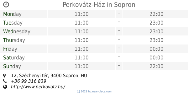
Perkovátz-Ház
Sopron, Széchenyi tér 12
Restaurant
read more
703 m
Duna Döner Sopron - Kebab, dürüm, pizza
Sopron, Ferenczy János utca 58
Restaurant
read more
750 m
Juicy Lucy Burger and Pasta
Sopron, Ferenczy János utca 48/a
Restaurant
read more
895 m
Harap6 falatozó
Sopron, Tómalom utca 34
Restaurant
read more
933 m
Kínai Gyorsbüfé Kkt.
Sopron, Lackner Kristóf utca 35
Restaurant
read more
982 m
VanKonyha
Sopron, Deák tér 28
Restaurant
read more
988 m
Old Boys
Sopron, 1, Gyár utca
Restaurant
read more
1.081 km
Fortuna Kávéház és Salátabár
Sopron, Mátyás király utca 34
Restaurant
read more
1.106 km
Jumbo Burger
Sopron, Bartók Béla utca 2
Restaurant
read more
1.208 km
Choco Kebab
Sopron, Unnamed Road
Restaurant
read more
1.236 km
McDonald's
Sopron, Lackner Kristóf utca 60
Restaurant
read more
📑
all categories
Accounting
Administrative area level 1
Administrative area level 2
Airport
Amusement park
Aquarium
Art gallery
Atm
Bakery
Bank
Bar
Beauty salon
Bicycle store
Book store
Bowling alley
Bus station
Cafe
Campground
Car dealer
Car rental
Car repair
Car wash
Casino
Cemetery
Church
City hall
Clothing store
Colloquial area
Convenience store
Country
Courthouse
Dentist
Department store
Doctor
Electrician
Electronics store
Embassy
Finance
Fire station
Florist
Food
Funeral home
Furniture store
Gas station
General contractor
Grocery or supermarket
Gym
Hair care
Hardware store
Health
Hindu Temple
Home goods store
Hospital
Insurance agency
Intersection
Jewelry store
Laundry
Lawyer
Library
Light rail station
Liquor store
Local government office
Locality
Locksmith
Lodging
Meal delivery
Meal takeaway
Mosque
Movie rental
Movie theater
Moving company
Museum
Natural feature
Neighborhood
Night club
Painter
Park
Parking
Pet store
Pharmacy
Physiotherapist
Place of worship
Plumber
Point of interest
Police
Political
Post office
Premise
Real estate agency
Restaurant
Roofing contractor
Route
Rv park, camping
School
Shoe store
Shopping mall
Spa
Stadium
Storage
Store
Subpremise
Subway station
Supermarket
Synagogue
Taxi stand
Train station
Transit station
Travel agency
University
Veterinary care
Zoo
administrative area level 3
sublocality level 1
↑