Restaurant nearby Café 57
Hungary
Restaurant nearby Café 57
Café 57
Budapest, Pusztaszeri út 57 Hungary
contacts phone
:
+36
Latitude:
47.5253863
, Longitude:
19.0239296
read more
nearest Restaurant
229 m
Az Öreg Pék
Pusztaszeri út 43/b
Restaurant
read more
458 m
Vadrózsa Étterem
Budapest, Pentelei Molnár utca 15
Restaurant
read more
635 m
Casa Piadina
Budapest, Szépvölgyi út 60
Restaurant
read more
748 m
Old City Keleti Etterem
Budapest, Gábor Áron utca 74
Restaurant
read more
755 m
Etna Ristorante & Pizzeria , Grill Terrazza
Budapest, Gábor Áron utca 74-78
Restaurant
read more
765 m
Aragvi Étterem
Budapest, Ürömi köz
Restaurant
read more
765 m
Aragvi Restaurant
Budapest, Ürömi köz
Restaurant
read more
769 m
Déjá-Vu Étterem és Kávézó
Budapest, Montevideo utca 3
Restaurant
read more
870 m
Cafe Teide
Montevideo utca 7
Restaurant
read more
899 m
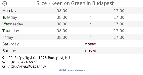
Slice - Keen on Green
Budapest, Szépvölgyi út 22
Restaurant
read more
955 m
Roham Budapest
Budapest, Montevideo utca 16
Restaurant
read more
973 m
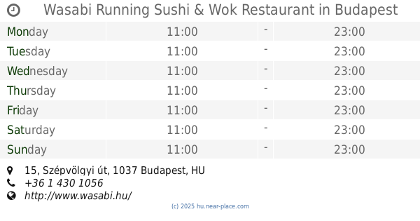
Wasabi Running Sushi & Wok Restaurant
Budapest, Szépvölgyi út 15
Restaurant
read more
973 m
Flat White Kitchen
Budapest, Szépvölgyi út 15
Restaurant
read more
986 m
IRánytű Étterem
Budapest, Mikoviny utca 2
Restaurant
read more
1.008 km
All-in-Delicates
Budapest, Folyondár utca 22-24
Restaurant
read more
1.058 km
Pata Negra Buda
Budapest, Frankel Leó út 55
Restaurant
read more
1.218 km
Dang Muoi
Budapest, Bécsi út 86
Restaurant
read more
1.254 km
Maharaja Indiai Étterem
Budapest, Bécsi út 89
Restaurant
read more
1.254 km
Maharaja Buda Bécsi
Budapest, Bécsi út 89-91
Restaurant
read more
1.254 km
Maharaja
Budapest, Bécsi út 89-91
Restaurant
read more
1.254 km
Maharaja Indian Restaurant
Budapest, Bécsi út 89
Restaurant
read more
1.261 km
Happy Facer
Budapest, Bécsi út
Restaurant
read more
1.281 km
Kerék Vendéglő
Budapest, Bécsi út 103
Restaurant
read more
1.305 km
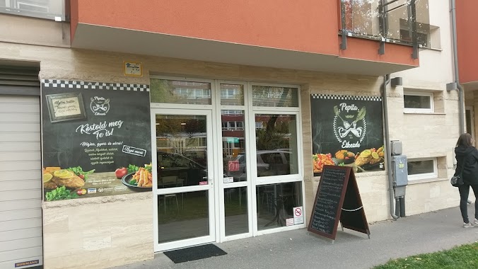
Pepita étkezde
Budapest, Bécsi út 107
Restaurant
read more
1.326 km
Nagyi Kifőzdéje
Budapest, 1023, Frankel Leó út 36
Restaurant
read more
📑
all categories
Accounting
Administrative area level 1
Administrative area level 2
Airport
Amusement park
Aquarium
Art gallery
Atm
Bakery
Bank
Bar
Beauty salon
Bicycle store
Book store
Bowling alley
Bus station
Cafe
Campground
Car dealer
Car rental
Car repair
Car wash
Casino
Cemetery
Church
City hall
Clothing store
Colloquial area
Convenience store
Country
Courthouse
Dentist
Department store
Doctor
Electrician
Electronics store
Embassy
Finance
Fire station
Florist
Food
Funeral home
Furniture store
Gas station
General contractor
Grocery or supermarket
Gym
Hair care
Hardware store
Health
Hindu Temple
Home goods store
Hospital
Insurance agency
Intersection
Jewelry store
Laundry
Lawyer
Library
Light rail station
Liquor store
Local government office
Locality
Locksmith
Lodging
Meal delivery
Meal takeaway
Mosque
Movie rental
Movie theater
Moving company
Museum
Natural feature
Neighborhood
Night club
Painter
Park
Parking
Pet store
Pharmacy
Physiotherapist
Place of worship
Plumber
Point of interest
Police
Political
Post office
Premise
Real estate agency
Restaurant
Roofing contractor
Route
Rv park, camping
School
Shoe store
Shopping mall
Spa
Stadium
Storage
Store
Subpremise
Subway station
Supermarket
Synagogue
Taxi stand
Train station
Transit station
Travel agency
University
Veterinary care
Zoo
administrative area level 3
sublocality level 1
↑