Premise nearby Erzsébet-ligeti uszoda
Hungary
Premise nearby Erzsébet-ligeti uszoda
Erzsébet-ligeti uszoda
Budapest Hungría
contacts phone
:
+36
Latitude:
47.508257
, Longitude:
19.2070364
read more
nearest Premise
Erzsébet-ligeti uszoda
Budapeszt
Premise
read more
173 m
MLTC sportpálya
Budapest
Premise
read more
431 m
4 emeletes panelház
XVI. kerület
Premise
read more
1.13 km
Omega Laser STEELTEC Kft.
Nagytarcsa, Cinkotai út 28
Premise
read more
1.218 km
Panelház
XVI. kerület
Premise
read more
2.463 km
Hermina Bringa Park
XVI. kerület
Premise
read more
2.467 km
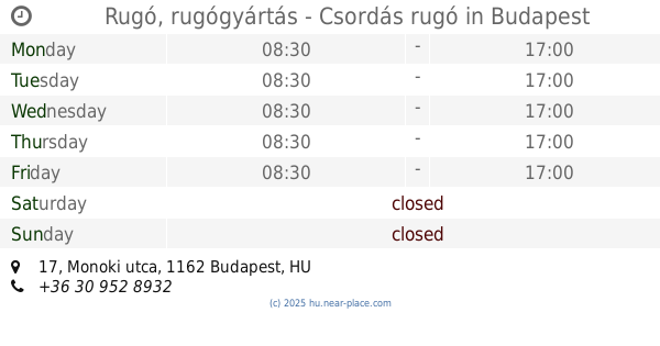
Rugó, rugógyártás - Csordás rugó
Budapest, Monoki utca 17
Premise
read more
2.742 km
Eltec Bussiness Park
Budapest, Tündérfürt utca 3-5
Premise
read more
2.742 km
Eltec Bussines Park
Budapest, Tündérfürt utca 3-5
Premise
read more
3.555 km
301-es parcella
X. kerület
Premise
read more
3.564 km
Central European University Residence Center
X. kerület
Premise
read more
3.876 km
1. Dünya Savaşı Galiçya Cephesi Şehitleri Budapeşte Türk Şehitliği
X. kerület
Premise
read more
4.077 km
Főbejárat, recepció
X. kerület
Premise
read more
4.416 km
Gyakorló utcai focipálya
Budapest
Premise
read more
4.544 km
Korábbi Norauto
Csömör
Premise
read more
4.564 km
NJSZKI
XIV. kerület
Premise
read more
4.719 km
Sírkert úti focipálya
X. kerület
Premise
read more
4.805 km
Korábbi BricoStore
Csömör
Premise
read more
4.936 km
ÉPFA pálya
Budapest
Premise
read more
5.38 km
Sorház utcai focipálya
X. kerület
Premise
read more
5.4 km
Pecsenyicki Mihály Sportcentrum - Kistarcsa Focipálya
Kistarcsa
Premise
read more
5.672 km
ALDI
XV. kerület
Premise
read more
5.68 km
Family Center
Budapeszt
Premise
read more
5.832 km
Lidl
Budapest
Premise
read more
12.875 km
1117
District XI.
Premise
read more
📑
all categories
Accounting
Administrative area level 1
Administrative area level 2
Airport
Amusement park
Aquarium
Art gallery
Atm
Bakery
Bank
Bar
Beauty salon
Bicycle store
Book store
Bowling alley
Bus station
Cafe
Campground
Car dealer
Car rental
Car repair
Car wash
Casino
Cemetery
Church
City hall
Clothing store
Colloquial area
Convenience store
Country
Courthouse
Dentist
Department store
Doctor
Electrician
Electronics store
Embassy
Finance
Fire station
Florist
Food
Funeral home
Furniture store
Gas station
General contractor
Grocery or supermarket
Gym
Hair care
Hardware store
Health
Hindu Temple
Home goods store
Hospital
Insurance agency
Intersection
Jewelry store
Laundry
Lawyer
Library
Light rail station
Liquor store
Local government office
Locality
Locksmith
Lodging
Meal delivery
Meal takeaway
Mosque
Movie rental
Movie theater
Moving company
Museum
Natural feature
Neighborhood
Night club
Painter
Park
Parking
Pet store
Pharmacy
Physiotherapist
Place of worship
Plumber
Point of interest
Police
Political
Post office
Premise
Real estate agency
Restaurant
Roofing contractor
Route
Rv park, camping
School
Shoe store
Shopping mall
Spa
Stadium
Storage
Store
Subpremise
Subway station
Supermarket
Synagogue
Taxi stand
Train station
Transit station
Travel agency
University
Veterinary care
Zoo
administrative area level 3
sublocality level 1
↑