Post office nearby Pilis posta
Hungary
Post office nearby Pilis posta
Pilis posta
Pilis, Rákóczi út 8. Magyarország
contacts phone
:
+36
Latitude:
47.28484
, Longitude:
19.5455819
read more
nearest Post office
Posta
Pilis, Rákóczi út 8.
Post office
read more
4.277 km
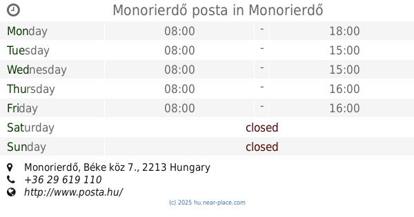
Monorierdő posta
Monorierdő, Béke köz 7.
Post office
read more
4.362 km
Nyáregyháza posta
Nyáregyháza, Nyáry Pál út 34.
Post office
read more
4.362 km
Posta
Nyáregyháza, Nyáry Pál út 34.
Post office
read more
6.706 km
Albertirsa posta
Albertirsa, Vasút utca 4/10
Post office
read more
6.706 km
Posta
Albertirsa, Vasút utca 4/10
Post office
read more
7.836 km
Bénye postapartner
Bénye, Fő út 80.
Post office
read more
8.86 km
Dánszentmiklós posta
Dánszentmiklós, Széchenyi utca 32.
Post office
read more
8.898 km
Csévharaszt posta
Csévharaszt, Kossuth Lajos utca 41.
Post office
read more
9.66 km
Posta
Gomba, Rákóczi Ferenc utca 2.
Post office
read more
10.554 km
Monor 1 posta
Monor, Petőfi Sándor utca 4.
Post office
read more
10.554 km
Posta
Monor, Petőfi Sándor utca 4.
Post office
read more
10.847 km
Posta
Monor, Jászai Mari tér 1
Post office
read more
10.847 km
Magyar Posta zrt.
Monor, Jászai Mari tér 1
Post office
read more
12.066 km
Posta
Ceglédbercel, Pesti út 132
Post office
read more
12.066 km
Ceglédbercel posta
Ceglédbercel, Pesti út 132
Post office
read more
12.82 km
Pusztavacs postapartner
Pusztavacs, Béke tér 8.
Post office
read more
12.901 km
Posta
Pusztavacs, Béke tér 9
Post office
read more
12.901 km
Magyar Posta Zrt.
Pusztavacs, Béke tér 9
Post office
read more
14.334 km
Tápióság posta
Tápióság, Rákóczi utca 26.
Post office
read more
15.409 km
Posta
Péteri, Petőfi Sándor utca 69.
Post office
read more
15.823 km
Cegléd 5 Budai út postakirendeltség
Cegléd, Külső Budai út 43.
Post office
read more
16.093 km
Hernád posta
Hernád, Köztársaság út 47.
Post office
read more
16.816 km
Posta
Hernád, Köztársaság út 42
Post office
read more
18.335 km
Posta
Üllő, Malom utca 14/a
Post office
read more
📑
all categories
Accounting
Administrative area level 1
Administrative area level 2
Airport
Amusement park
Aquarium
Art gallery
Atm
Bakery
Bank
Bar
Beauty salon
Bicycle store
Book store
Bowling alley
Bus station
Cafe
Campground
Car dealer
Car rental
Car repair
Car wash
Casino
Cemetery
Church
City hall
Clothing store
Colloquial area
Convenience store
Country
Courthouse
Dentist
Department store
Doctor
Electrician
Electronics store
Embassy
Finance
Fire station
Florist
Food
Funeral home
Furniture store
Gas station
General contractor
Grocery or supermarket
Gym
Hair care
Hardware store
Health
Hindu Temple
Home goods store
Hospital
Insurance agency
Intersection
Jewelry store
Laundry
Lawyer
Library
Light rail station
Liquor store
Local government office
Locality
Locksmith
Lodging
Meal delivery
Meal takeaway
Mosque
Movie rental
Movie theater
Moving company
Museum
Natural feature
Neighborhood
Night club
Painter
Park
Parking
Pet store
Pharmacy
Physiotherapist
Place of worship
Plumber
Point of interest
Police
Political
Post office
Premise
Real estate agency
Restaurant
Roofing contractor
Route
Rv park, camping
School
Shoe store
Shopping mall
Spa
Stadium
Storage
Store
Subpremise
Subway station
Supermarket
Synagogue
Taxi stand
Train station
Transit station
Travel agency
University
Veterinary care
Zoo
administrative area level 3
sublocality level 1
↑