Post office nearby Galgaguta posta
Hungary
Post office nearby Galgaguta posta
Galgaguta posta
Galgaguta, Kossuth út 15. Magyarország
contacts phone
:
+36
Latitude:
47.846523
, Longitude:
19.389451
read more
nearest Post office
2.554 km
Magyar Posta
Nógrádsáp, Szent István utca 4
Post office
read more
2.61 km
Nógrádsáp fiókposta
Nógrádsáp, Szent István út 4.
Post office
read more
2.613 km
Posta
Nógrádsáp
Post office
read more
2.917 km
Bercel posta
Bercel, Baross út 20.
Post office
read more
5.241 km
Vanyarc postapartner
Vanyarc, Veres Pálné út 97.
Post office
read more
5.983 km
Posta
Csővár, Madách út 4
Post office
read more
6.01 km
Posta
Csővár, Madách utca
Post office
read more
6.686 km
Legénd postapartner
Legénd, Petőfi Sándor út 4.
Post office
read more
7.162 km
Becske posta
Becske, Fő út 13.
Post office
read more
9.608 km
Erdőkürt posta
Erdőkürt, Tanács út 2.
Post office
read more
11.28 km
Paholikné Marcsok Éva
Alsópetény, Petőfi út 22
Post office
read more
12.976 km
Püspökszilágy posta
Püspökszilágy, Kossuth Lajos út 9.
Post office
read more
13.267 km
Posta
Kálló, Erzsébet királyné utca 1.
Post office
read more
13.907 km
Rád posta
Rád, Rákóczi út 20.
Post office
read more
13.965 km
Magyarnándor posta
Magyarnándor, Fő út 90.
Post office
read more
14.743 km
Cserhátsurány posta
Cserhátsurány, Petőfi út 5.
Post office
read more
15.247 km
Felsőpetény postapartner
Felsőpetény, Ságvári Endre utca 5.
Post office
read more
15.268 km
Posta
Felsőpetény, Szabadság utca 5
Post office
read more
15.586 km
Herencsény postapartner
Herencsény, Kossuth út 13.
Post office
read more
17.386 km
Posta
Vácduka, Béke tér 1
Post office
read more
17.386 km
Magyar Posta Zrt.
Vácduka, Béke tér 1
Post office
read more
18.183 km
Verseg posta
Verseg, Fő utca 3.
Post office
read more
18.183 km
Posta
Verseg, Fő utca 3.
Post office
read more
19.201 km
Csörög postakirendeltség
Csörög, Kisfaludy utca 40.
Post office
read more
20.948 km
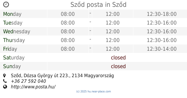
Sződ posta
Sződ, Dózsa György út 223.
Post office
read more
📑
all categories
Accounting
Administrative area level 1
Administrative area level 2
Airport
Amusement park
Aquarium
Art gallery
Atm
Bakery
Bank
Bar
Beauty salon
Bicycle store
Book store
Bowling alley
Bus station
Cafe
Campground
Car dealer
Car rental
Car repair
Car wash
Casino
Cemetery
Church
City hall
Clothing store
Colloquial area
Convenience store
Country
Courthouse
Dentist
Department store
Doctor
Electrician
Electronics store
Embassy
Finance
Fire station
Florist
Food
Funeral home
Furniture store
Gas station
General contractor
Grocery or supermarket
Gym
Hair care
Hardware store
Health
Hindu Temple
Home goods store
Hospital
Insurance agency
Intersection
Jewelry store
Laundry
Lawyer
Library
Light rail station
Liquor store
Local government office
Locality
Locksmith
Lodging
Meal delivery
Meal takeaway
Mosque
Movie rental
Movie theater
Moving company
Museum
Natural feature
Neighborhood
Night club
Painter
Park
Parking
Pet store
Pharmacy
Physiotherapist
Place of worship
Plumber
Point of interest
Police
Political
Post office
Premise
Real estate agency
Restaurant
Roofing contractor
Route
Rv park, camping
School
Shoe store
Shopping mall
Spa
Stadium
Storage
Store
Subpremise
Subway station
Supermarket
Synagogue
Taxi stand
Train station
Transit station
Travel agency
University
Veterinary care
Zoo
administrative area level 3
sublocality level 1
↑