Post office nearby Csomád Posta
Hungary
Post office nearby Csomád Posta
Csomád Posta
Csomád, Kossuth Lajos út 69 Magyarország
contacts phone
:
+36
Latitude:
47.660064
, Longitude:
19.231321
read more
nearest Post office
3 m
Csomád postapartner
Csomád, Kossuth Lajos út 69.
Post office
read more
4.313 km
Őrbottyán posta
Őrbottyán, Rákóczi Ferenc utca 90.
Post office
read more
4.313 km
Posta
Őrbottyán, Rákóczi Ferenc utca 90.
Post office
read more
4.363 km
Veresegyház posta
Veresegyház, Fő út 32.
Post office
read more
4.363 km
Posta
Veresegyház, Fő út 32.
Post office
read more
5.227 km
Fót 2 Posta
Fót, Németh Kálmán út 40.
Post office
read more
5.53 km
Fót 1 posta
Fót, Szent Benedek utca 17.
Post office
read more
6.942 km
Posta
Mogyoród, Fóti út 10
Post office
read more
7.909 km
God Felsőgöd 2 post
Göd, Ady Endre út 28.
Post office
read more
8.199 km
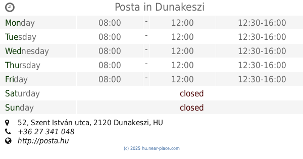
Posta
Dunakeszi, Szent István utca 52
Post office
read more
9.612 km
Posta
Vácduka, Béke tér 1
Post office
read more
10.324 km
Dunakeszi Auchan posta
Dunakeszi, Nádas utca 6.
Post office
read more
10.82 km
Posta
Gödöllő, Dózsa György út 15.
Post office
read more
12.31 km
Posta
Leányfalu, Móricz Zsigmond út 157.
Post office
read more
13.003 km
Szentendre 3 postakirendeltség
Szentendre, Fehérvíz utca 20.
Post office
read more
13.319 km
Gödöllő Máriabesnyő postakirendeltség
Gödöllő, Szabadság út 179
Post office
read more
13.528 km
Budapest Rákospalota 1 posta
Budapest, Fő út 68.
Post office
read more
14.475 km
Posta
Budapest, Állás utca 43.
Post office
read more
14.954 km
Rád posta
Rád, Rákóczi út 20.
Post office
read more
15.458 km
Tahitótfalu 2 posta
Tahitótfalu, Visegrádi út 2.
Post office
read more
15.937 km
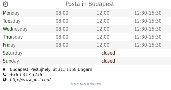
Posta
Budapest, Pestújhelyi út 31.
Post office
read more
16.256 km
Budapest Váci úti TESCO posta
Budapest, Gács utca 3.
Post office
read more
16.256 km
Posta
Budapest, Gács utca 3.
Post office
read more
16.314 km
Vác 3 posta
Vác, Deákvári főtér 7.
Post office
read more
18.152 km
Posta
Budapest, Pethe Ferenc tér 1
Post office
read more
📑
all categories
Accounting
Administrative area level 1
Administrative area level 2
Airport
Amusement park
Aquarium
Art gallery
Atm
Bakery
Bank
Bar
Beauty salon
Bicycle store
Book store
Bowling alley
Bus station
Cafe
Campground
Car dealer
Car rental
Car repair
Car wash
Casino
Cemetery
Church
City hall
Clothing store
Colloquial area
Convenience store
Country
Courthouse
Dentist
Department store
Doctor
Electrician
Electronics store
Embassy
Finance
Fire station
Florist
Food
Funeral home
Furniture store
Gas station
General contractor
Grocery or supermarket
Gym
Hair care
Hardware store
Health
Hindu Temple
Home goods store
Hospital
Insurance agency
Intersection
Jewelry store
Laundry
Lawyer
Library
Light rail station
Liquor store
Local government office
Locality
Locksmith
Lodging
Meal delivery
Meal takeaway
Mosque
Movie rental
Movie theater
Moving company
Museum
Natural feature
Neighborhood
Night club
Painter
Park
Parking
Pet store
Pharmacy
Physiotherapist
Place of worship
Plumber
Point of interest
Police
Political
Post office
Premise
Real estate agency
Restaurant
Roofing contractor
Route
Rv park, camping
School
Shoe store
Shopping mall
Spa
Stadium
Storage
Store
Subpremise
Subway station
Supermarket
Synagogue
Taxi stand
Train station
Transit station
Travel agency
University
Veterinary care
Zoo
administrative area level 3
sublocality level 1
↑