Post office nearby Bakonycsernye posta
Hungary
Post office nearby Bakonycsernye posta
Bakonycsernye posta
Bakonycsernye, Rákóczi út 69. Hungary
contacts phone
:
+36
Latitude:
47.319345
, Longitude:
18.0872079
read more
nearest Post office
6.974 km
Csetény posta
Csetény, Rákóczi utca 2.
Post office
read more
6.974 km
Posta
Csetény, Rákóczi utca 2.
Post office
read more
7.037 km
Súr posta
Súr, Kossuth Lajos utca 5.
Post office
read more
8.214 km
Tés posta
Tés, Petőfi Sándor utca 19.
Post office
read more
8.713 km
Magyar Posta
Balinka, Gajavölgy utca 46
Post office
read more
8.723 km
Balinka postapartner
Balinka, Gajavölgy utca 46.
Post office
read more
9.919 km
Bakonynána posta
Bakonynána, Hidegkúti utca 1.
Post office
read more
9.919 km
Posta
Bakonynána, Hidegkúti utca 1.
Post office
read more
9.955 km
Postahivatal
Bakonynána, Hidegkúti utca 9
Post office
read more
11.175 km
Mór 1 posta
Mór, Kapucinus tér 5.
Post office
read more
11.352 km
Dudar postapartner
Dudar, Berek park 1.
Post office
read more
11.415 km
Magyar Posta
Ácsteszér, Kossuth Lajos utca 47/b
Post office
read more
11.518 km
Bodajk posta
Bodajk, Petőfi Sándor utca 76.
Post office
read more
13.588 km
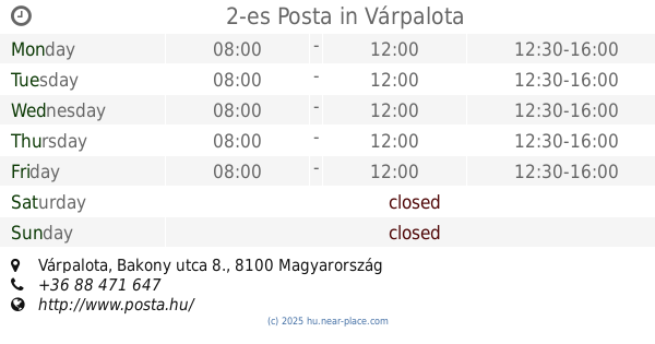
2-es Posta
Várpalota, Bakony utca 8.
Post office
read more
13.684 km
Fehérvárcsurgó posta
Fehérvárcsurgó, Petőfi Sándor utca 16.
Post office
read more
13.684 km
Posta
Fehérvárcsurgó, Petőfi Sándor utca 16.
Post office
read more
13.784 km
Posta
Várpalota, Szent István út 5
Post office
read more
14.065 km
Csókakő posta
Csókakő, Kossuth Lajos utca 41/a, Posta
Post office
read more
14.088 km
Posta
Csókakő, Kossuth Lajos utca 39
Post office
read more
14.534 km
Posta
Nagyesztergár, Radnóti Miklós utca 58.
Post office
read more
15.506 km
Kincsesbánya posta
Kincsesbánya, Kincsesi utca 37.
Post office
read more
15.852 km
Posta
Olaszfalu, major utca 1
Post office
read more
16.292 km
Pusztavám posta
Pusztavám, Petőfi Sándor utca 1.
Post office
read more
18.106 km
Posta
Csór, Fő tér 10.
Post office
read more
18.106 km
Csór posta
Csór, Fő tér 10.
Post office
read more
📑
all categories
Accounting
Administrative area level 1
Administrative area level 2
Airport
Amusement park
Aquarium
Art gallery
Atm
Bakery
Bank
Bar
Beauty salon
Bicycle store
Book store
Bowling alley
Bus station
Cafe
Campground
Car dealer
Car rental
Car repair
Car wash
Casino
Cemetery
Church
City hall
Clothing store
Colloquial area
Convenience store
Country
Courthouse
Dentist
Department store
Doctor
Electrician
Electronics store
Embassy
Finance
Fire station
Florist
Food
Funeral home
Furniture store
Gas station
General contractor
Grocery or supermarket
Gym
Hair care
Hardware store
Health
Hindu Temple
Home goods store
Hospital
Insurance agency
Intersection
Jewelry store
Laundry
Lawyer
Library
Light rail station
Liquor store
Local government office
Locality
Locksmith
Lodging
Meal delivery
Meal takeaway
Mosque
Movie rental
Movie theater
Moving company
Museum
Natural feature
Neighborhood
Night club
Painter
Park
Parking
Pet store
Pharmacy
Physiotherapist
Place of worship
Plumber
Point of interest
Police
Political
Post office
Premise
Real estate agency
Restaurant
Roofing contractor
Route
Rv park, camping
School
Shoe store
Shopping mall
Spa
Stadium
Storage
Store
Subpremise
Subway station
Supermarket
Synagogue
Taxi stand
Train station
Transit station
Travel agency
University
Veterinary care
Zoo
administrative area level 3
sublocality level 1
↑