Park nearby Tóalmási focipálya
Hungary
Park nearby Tóalmási focipálya
Tóalmási focipálya
Tóalmás Magyarország
contacts phone
:
+36
Latitude:
47.5131057
, Longitude:
19.6561974
read more
nearest Park
7.073 km
Kókai focipálya
Kóka
Park
read more
7.519 km
Dányi focipálya
Dány
Park
read more
8.304 km
Jászfényszarui focipálya
Jászfényszaru
Park
read more
8.989 km
Tápiószecsői focipálya
Tápiószecső
Park
read more
9.689 km
Boldogi focipálya
Boldog
Park
read more
10.85 km
Hajta-mocsár Természetvédelmi Terület
Jászberény, Külterület
Park
read more
11.119 km
Régi Vásártér úti sporttelep
Tura
Park
read more
11.36 km
Turai legelő Természetvédelmi Terület
Tura, a Galga-patak mentén
Park
read more
11.412 km
Szent László park
Vácszentlászló, Valkói út 6-7
Park
read more
12.466 km
Szabadsag Emlekmu
Nagykáta
Park
read more
12.866 km
Zagyvamenti Természetvédelmi Terület
Jászberény, Jászfelsőszentgyörgyi út mentén
Park
read more
12.981 km
Dózsa György utcai focipálya
Sülysáp
Park
read more
13.785 km
Nagykáta SE Sportpálya
Nagykáta
Park
read more
14.654 km
Kegyeleti Park
Galgahévíz
Park
read more
16.946 km
Hévízgyörki focipálya
Hévízgyörk
Park
read more
17.21 km
Jászágói focipálya
Jászágó
Park
read more
18.058 km
Szent István park
Mende
Park
read more
19.128 km
Bagi focipálya
Bag
Park
read more
19.276 km
Képesfa, Bag
Bag
Park
read more
19.471 km
Conselve Park
Jászberény
Park
read more
21.537 km
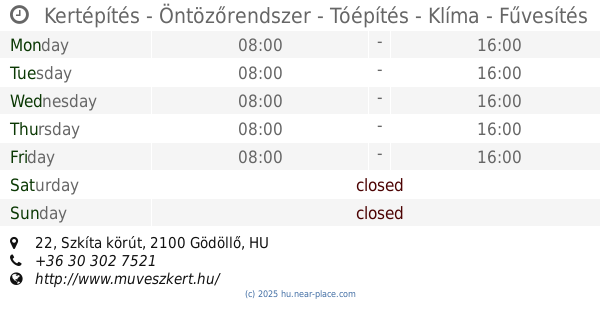
Kertépítés - Öntözőrendszer - Tóépítés - Klíma - Fűvesítés
Gödöllő, Szkíta körút 22
Park
read more
24.957 km
Árpád-házi Szent Erzsébet Sétány
Jászjákóhalma, Fő út 74
Park
read more
26.176 km
Erzsébet park
Gödöllő
Park
read more
27.181 km
Tápiószele People's Garden
Tápiószele
Park
read more
27.754 km
Jászárokszállási focipálya
Jászárokszállás
Park
read more
📑
all categories
Accounting
Administrative area level 1
Administrative area level 2
Airport
Amusement park
Aquarium
Art gallery
Atm
Bakery
Bank
Bar
Beauty salon
Bicycle store
Book store
Bowling alley
Bus station
Cafe
Campground
Car dealer
Car rental
Car repair
Car wash
Casino
Cemetery
Church
City hall
Clothing store
Colloquial area
Convenience store
Country
Courthouse
Dentist
Department store
Doctor
Electrician
Electronics store
Embassy
Finance
Fire station
Florist
Food
Funeral home
Furniture store
Gas station
General contractor
Grocery or supermarket
Gym
Hair care
Hardware store
Health
Hindu Temple
Home goods store
Hospital
Insurance agency
Intersection
Jewelry store
Laundry
Lawyer
Library
Light rail station
Liquor store
Local government office
Locality
Locksmith
Lodging
Meal delivery
Meal takeaway
Mosque
Movie rental
Movie theater
Moving company
Museum
Natural feature
Neighborhood
Night club
Painter
Park
Parking
Pet store
Pharmacy
Physiotherapist
Place of worship
Plumber
Point of interest
Police
Political
Post office
Premise
Real estate agency
Restaurant
Roofing contractor
Route
Rv park, camping
School
Shoe store
Shopping mall
Spa
Stadium
Storage
Store
Subpremise
Subway station
Supermarket
Synagogue
Taxi stand
Train station
Transit station
Travel agency
University
Veterinary care
Zoo
administrative area level 3
sublocality level 1
↑