Park nearby Park
Hungary
Park nearby Park
Park
Budapest, Pestújhely, 1154 Ungarn
contacts phone
:
+36
Latitude:
47.5440198
, Longitude:
19.1279024
larger map & directions
read more
nearest Park
776 m
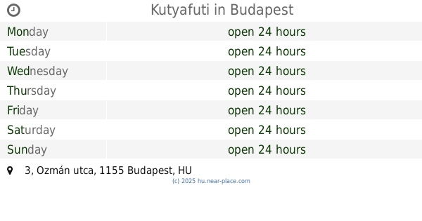
Kutyafuti
Budapest, 47°32'40.0"N 19°07'03., Ozmán utca 3
Park
read more
1000 m
Fő tér
Budapest, Fő tér
Park
read more
1000 m
Main square
Budapest, Fő tér
Park
read more
1.041 km
pazmany peter ut
Budapest, Fő tér
Park
read more
1.074 km
Obsitos tér
XV. kerület
Park
read more
1.087 km
Zöldpalota közösségi kert
Budapest, Nyírpalota út 109
Park
read more
1.115 km
Pestújhelyi Helytörténeti Emlékfasor
Budapest, 57,, Bezsilla Nándor utca 55
Park
read more
1.126 km
Újpalota liget
Budapest
Park
read more
1.438 km
Karatna tér
XV. kerület
Park
read more
1.482 km
Páskomliget-park
Rákospalota
Park
read more
1.728 km
dpd
Budapest, u 1158, Késmárk utca 14
Park
read more
1.952 km
Zöld bagoly a kerttudor
Budapest, Bethlen Gábor utca 44a
Park
read more
1.976 km
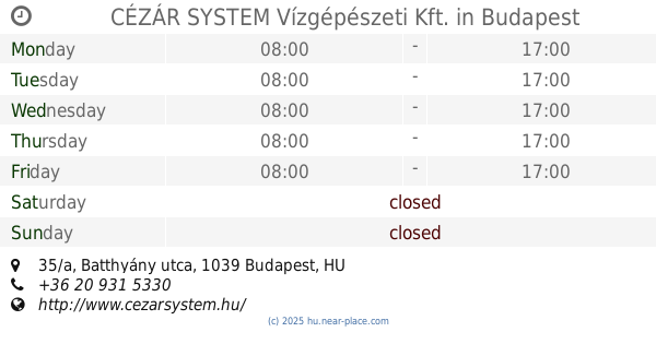
CÉZÁR SYSTEM Vízgépészeti Kft.
Budapest, Batthyány utca 35/a
Park
read more
2.148 km
Szilas park
Rákospalota
Park
read more
2.196 km
Patakparti Fitneszpark
Budapest
Park
read more
2.337 km
Városháza park
Budapest Deák F. utca
Park
read more
2.385 km
Karácsony Benő park
Budapest, Karácsony Benő park
Park
read more
2.499 km
Kaszás és Társa Bt
Budapest, Nyár utca 95
Park
read more
2.661 km
Széchenyi tér
IV. kerület
Park
read more
2.883 km
CityGreen - Növénygondozás A-tól Z-ig
Budapest, Bonyhádi út 102a
Park
read more
3.038 km
Pozsonyi lakótelep, Kutyafuttató
IV. kerület
Park
read more
3.31 km
dr. Boromisza Zsombor - tájvédelmi szakértő
Budapest, Munkácsy Mihály utca 58/a
Park
read more
3.319 km
Semsey Aladár park
Budapest
Park
read more
3.319 km
Semsey Aladár park
Budapeszt
Park
read more
4.154 km
Reformátorok Tere
Budapest, Sashalom utca 6
Park
read more
📑
all categories
Accounting
Administrative area level 1
Administrative area level 2
Airport
Amusement park
Aquarium
Art gallery
Atm
Bakery
Bank
Bar
Beauty salon
Bicycle store
Book store
Bowling alley
Bus station
Cafe
Campground
Car dealer
Car rental
Car repair
Car wash
Casino
Cemetery
Church
City hall
Clothing store
Colloquial area
Convenience store
Country
Courthouse
Dentist
Department store
Doctor
Electrician
Electronics store
Embassy
Finance
Fire station
Florist
Food
Funeral home
Furniture store
Gas station
General contractor
Grocery or supermarket
Gym
Hair care
Hardware store
Health
Hindu Temple
Home goods store
Hospital
Insurance agency
Intersection
Jewelry store
Laundry
Lawyer
Library
Light rail station
Liquor store
Local government office
Locality
Locksmith
Lodging
Meal delivery
Meal takeaway
Mosque
Movie rental
Movie theater
Moving company
Museum
Natural feature
Neighborhood
Night club
Painter
Park
Parking
Pet store
Pharmacy
Physiotherapist
Place of worship
Plumber
Point of interest
Police
Political
Post office
Premise
Real estate agency
Restaurant
Roofing contractor
Route
Rv park, camping
School
Shoe store
Shopping mall
Spa
Stadium
Storage
Store
Subpremise
Subway station
Supermarket
Synagogue
Taxi stand
Train station
Transit station
Travel agency
University
Veterinary care
Zoo
administrative area level 3
sublocality level 1
↑