Park nearby NAIK ERTI Kámoni Arborétum
Hungary
Park nearby NAIK ERTI Kámoni Arborétum
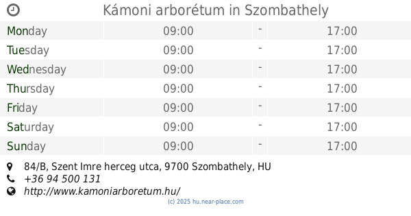
NAIK ERTI Kámoni Arborétum
Szombathely, 84/B, Szent Imre herceg útja, 9700 Magyarország
contacts phone
:
+36 94 500 343
website:
www.kamoniarboretum.hu
Latitude:
47.2524588
, Longitude:
16.6069577
larger map & directions
read more
nearest Park
Kamon Arboretum
Szombathely, 84/B, Szent Imre herceg útja
Park
read more
5 m
Kámoni arborétum
Szombathely, Szent Imre herceg utca 84/B
Park
read more
5 m
NAIK ERTI Kámoni Arborétum
Szombathely, Szent Imre herceg utca 84/B
Park
read more
661 m
Arborétum sportcentrum
Szombathely
Park
read more
1.766 km
Tóth Géza Tér
Szombathely
Park
read more
1.831 km
Ifjúsági sporttelep
Szombathely
Park
read more
2.044 km
Zolla Kft.
Szombathely, Rohonci út 10
Park
read more
2.108 km
Pelikán park
Szombathely, 48-as honvéd utca
Park
read more
2.108 km
Park Pelikan
Szombathely, 48-as honvéd utca
Park
read more
2.114 km
Kenderesi utcai Sporttelep
Szombathely
Park
read more
2.287 km
Ady Endre tér
Szombathely
Park
read more
2.427 km
Illés Akadémia műfüves pálya
Szombathely
Park
read more
2.442 km
Ezredévi park
Szombathely
Park
read more
2.509 km
Múzeum-park
Szombathely
Park
read more
2.513 km
Károlyi Gáspár tér
Szombathely
Park
read more
2.65 km
Main Square Fountain
Szombathely, Fő tér
Park
read more
2.65 km
Fő téri szökőkút
Szombathely, Fő tér
Park
read more
2.658 km
Városmakett.Szombathely
Szombathely, Fő tér 21-22
Park
read more
2.778 km
Szent István park
Szombathely
Park
read more
2.828 km
Szent Márton Square
Szombathely, Szent Márton utca 38
Park
read more
2.828 km
Szent Márton tér
Szombathely, Szent Márton utca 38
Park
read more
2.834 km
Evangélikusok tere
Szombathely
Park
read more
2.985 km
Gayer park
Szombathely, Zrínyi Ilona utca
Park
read more
3.266 km
Brenner park
Szombathely
Park
read more
3.31 km
Kresz- Park
Szombathely, Szent Flórián körút 9
Park
read more
📑
all categories
Accounting
Administrative area level 1
Administrative area level 2
Airport
Amusement park
Aquarium
Art gallery
Atm
Bakery
Bank
Bar
Beauty salon
Bicycle store
Book store
Bowling alley
Bus station
Cafe
Campground
Car dealer
Car rental
Car repair
Car wash
Casino
Cemetery
Church
City hall
Clothing store
Colloquial area
Convenience store
Country
Courthouse
Dentist
Department store
Doctor
Electrician
Electronics store
Embassy
Finance
Fire station
Florist
Food
Funeral home
Furniture store
Gas station
General contractor
Grocery or supermarket
Gym
Hair care
Hardware store
Health
Hindu Temple
Home goods store
Hospital
Insurance agency
Intersection
Jewelry store
Laundry
Lawyer
Library
Light rail station
Liquor store
Local government office
Locality
Locksmith
Lodging
Meal delivery
Meal takeaway
Mosque
Movie rental
Movie theater
Moving company
Museum
Natural feature
Neighborhood
Night club
Painter
Park
Parking
Pet store
Pharmacy
Physiotherapist
Place of worship
Plumber
Point of interest
Police
Political
Post office
Premise
Real estate agency
Restaurant
Roofing contractor
Route
Rv park, camping
School
Shoe store
Shopping mall
Spa
Stadium
Storage
Store
Subpremise
Subway station
Supermarket
Synagogue
Taxi stand
Train station
Transit station
Travel agency
University
Veterinary care
Zoo
administrative area level 3
sublocality level 1
↑