Park nearby MILLENARY PARK
Hungary
Park nearby MILLENARY PARK
MILLENARY PARK
4, 1024, Budapest, HU Hungría
contacts phone
:
+36 30 685 7028
website:
www.millenaris.hu
Latitude:
47.510832
, Longitude:
19.024845
larger map & directions
read more
nearest Park
114 m
Millenáris
Budapest, Kis Rókus utca
Park
read more
119 m
Györffy Tree Expert
Budapest, Lövőház utca 28
Park
read more
337 m
Széna tér
Budapest, Varsányi Irén utca 37
Park
read more
437 m
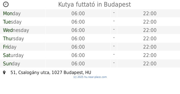
Kutya futtató
Budapest, Csalogány utca 51
Park
read more
463 m
Bibó parki kutyafuttató
Budapest, Bimbó út 35
Park
read more
498 m
Varosmajori Elso Kutyafuttato
Budapest, Városmajor utca
Park
read more
551 m
Mechwart liget
Budapest, Margit körút 47-49
Park
read more
630 m
Jordán-Táj Kert ésTájépítész Stúdió Bt.
Budapest, Buday László utca 7
Park
read more
634 m
Citi-Kert Bt. Kertépítés és Kertfenntartás
Budapest, Buday László utca 7
Park
read more
640 m
Városmajor
Budapest, Szilágyi Erzsébet fasor
Park
read more
657 m
Papkerti kutyafuttató
Budapest, Mechwart tér 1
Park
read more
736 m
Tóth Árpád park
Krisztinaváros
Park
read more
747 m
Városmajori kutyafuttató
Budapest, Temes utca
Park
read more
768 m
Európa Liget
Budapest, Európa liget
Park
read more
807 m
Margit utcai park
II. kerület
Park
read more
812 m
Magyar Jakobinusok kivégzésének emlékére
Budapest, Vérmező park
Park
read more
874 m
Mansfeld Péter park
Budapest, Veronika utca 6
Park
read more
924 m
Sportpark
Krisztinaváros
Park
read more
1.161 km
Molnár János-barlang
Budapest, Frankel Leó út 48
Park
read more
1.161 km
Molnár János Cave
Budapest, Frankel Leó út 48
Park
read more
1.173 km
Vérhalom téri park és játszótér
Budapest, Vérhalom tér
Park
read more
1.202 km
Mansfeld Peter Memorial
Budapest, Mansfeld Péter utca 27
Park
read more
1.656 km
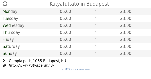
Kutyafuttató
Budapest, Olimpia park
Park
read more
1.667 km
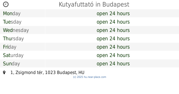
Kutyafuttató
Budapest, Zsigmond tér 1
Park
read more
1.684 km
Buty na brzegu Dunaju
Budapest, Idősebb Antall József rakpart
Park
read more
📑
all categories
Accounting
Administrative area level 1
Administrative area level 2
Airport
Amusement park
Aquarium
Art gallery
Atm
Bakery
Bank
Bar
Beauty salon
Bicycle store
Book store
Bowling alley
Bus station
Cafe
Campground
Car dealer
Car rental
Car repair
Car wash
Casino
Cemetery
Church
City hall
Clothing store
Colloquial area
Convenience store
Country
Courthouse
Dentist
Department store
Doctor
Electrician
Electronics store
Embassy
Finance
Fire station
Florist
Food
Funeral home
Furniture store
Gas station
General contractor
Grocery or supermarket
Gym
Hair care
Hardware store
Health
Hindu Temple
Home goods store
Hospital
Insurance agency
Intersection
Jewelry store
Laundry
Lawyer
Library
Light rail station
Liquor store
Local government office
Locality
Locksmith
Lodging
Meal delivery
Meal takeaway
Mosque
Movie rental
Movie theater
Moving company
Museum
Natural feature
Neighborhood
Night club
Painter
Park
Parking
Pet store
Pharmacy
Physiotherapist
Place of worship
Plumber
Point of interest
Police
Political
Post office
Premise
Real estate agency
Restaurant
Roofing contractor
Route
Rv park, camping
School
Shoe store
Shopping mall
Spa
Stadium
Storage
Store
Subpremise
Subway station
Supermarket
Synagogue
Taxi stand
Train station
Transit station
Travel agency
University
Veterinary care
Zoo
administrative area level 3
sublocality level 1
↑