Park nearby Martinovics téri szökőkút
Hungary
Park nearby Martinovics téri szökőkút
Martinovics téri szökőkút
Martinovics tér, 2234, Maglód, HU Magyarország
contacts phone
:
+36
Latitude:
47.4418507
, Longitude:
19.363441
larger map & directions
read more
nearest Park
27 m
Martinovics tér
Maglód
Park
read more
712 m
Árpád vezér szobor és park
Maglód, Kossuth Lajos utca 81
Park
read more
1.036 km
Szent István téri szökőkút
Maglód, Bajcsy-Zsilinszky utca
Park
read more
1.672 km
Wodianer Park
Maglód, HRSZ:499/10, Kastély köz 2
Park
read more
3.205 km
Szabadság park
Gyömrő
Park
read more
3.224 km
Ecseri Lakodalmas
Ecser, Széchenyi utca 35
Park
read more
3.413 km
Millenniumi Emlékpark
Ecser, Rákóczi utca
Park
read more
3.48 km
Gyömrői focipálya
Gyömrő
Park
read more
3.511 km
Ecseri focipálya
Ecser
Park
read more
3.894 km
Vadászles
Pécel
Park
read more
4.611 km
Vida-domb
Budapest, Pásztorfalva utca
Park
read more
4.721 km
Vadászles
Maglód
Park
read more
5.017 km
Paula kút
Pécel, Maglódi út 12
Park
read more
5.303 km
Ferihegy leszálló
Vecsés, Unnamed Rd 2220
Park
read more
6.007 km
Táj-kertész 84 Kft - Dísznövény Kis- Nagykereskedés - Gazdabolt, Kertépítés, Öntözőrendszerek
Budapest, Pesti út 239
Park
read more
6.377 km
Sport téri focipálya
Budapest
Park
read more
6.71 km
Szent István park
Mende
Park
read more
8.495 km
Szantofold
13567/553, 1523 Helyrajzi szám utca
Park
read more
8.632 km
SRMaster - "Kulcsrakész" kert
Budapest, Bélavár utca 77
Park
read more
11.966 km
Park
Monor, Kossuth Lajos utca 81
Park
read more
12.725 km
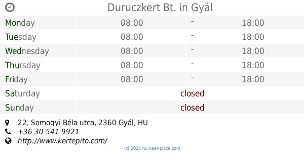
Duruczkert Bt.
Gyál, Somogyi Béla utca 22
Park
read more
14 km
Szent Imre Szobor
Kistarcsa, Batthyány utca 2
Park
read more
14.05 km
Kutya Futtató
Budapest
Park
read more
14.419 km
Mátyás király tér
Budapest
Park
read more
16.738 km
Sashalom City Center
Budapest, Karát utca 6-14
Park
read more
📑
all categories
Accounting
Administrative area level 1
Administrative area level 2
Airport
Amusement park
Aquarium
Art gallery
Atm
Bakery
Bank
Bar
Beauty salon
Bicycle store
Book store
Bowling alley
Bus station
Cafe
Campground
Car dealer
Car rental
Car repair
Car wash
Casino
Cemetery
Church
City hall
Clothing store
Colloquial area
Convenience store
Country
Courthouse
Dentist
Department store
Doctor
Electrician
Electronics store
Embassy
Finance
Fire station
Florist
Food
Funeral home
Furniture store
Gas station
General contractor
Grocery or supermarket
Gym
Hair care
Hardware store
Health
Hindu Temple
Home goods store
Hospital
Insurance agency
Intersection
Jewelry store
Laundry
Lawyer
Library
Light rail station
Liquor store
Local government office
Locality
Locksmith
Lodging
Meal delivery
Meal takeaway
Mosque
Movie rental
Movie theater
Moving company
Museum
Natural feature
Neighborhood
Night club
Painter
Park
Parking
Pet store
Pharmacy
Physiotherapist
Place of worship
Plumber
Point of interest
Police
Political
Post office
Premise
Real estate agency
Restaurant
Roofing contractor
Route
Rv park, camping
School
Shoe store
Shopping mall
Spa
Stadium
Storage
Store
Subpremise
Subway station
Supermarket
Synagogue
Taxi stand
Train station
Transit station
Travel agency
University
Veterinary care
Zoo
administrative area level 3
sublocality level 1
↑