Park nearby Kerepesi focipálya
Hungary
Park nearby Kerepesi focipálya
Kerepesi focipálya
Kerepes, Bartók Béla utca, 2144 Magyarország
contacts phone
:
+36
Latitude:
47.5611104
, Longitude:
19.2803616
larger map & directions
read more
nearest Park
692 m
Reproach of Kerepes
Kerepes, Széphegyi út
Park
read more
723 m
Emlékpark
Kerepes, rét utca 1
Park
read more
1.094 km
Szabó Magda kopjafa / emlékmű
Kerepes
Park
read more
1.668 km
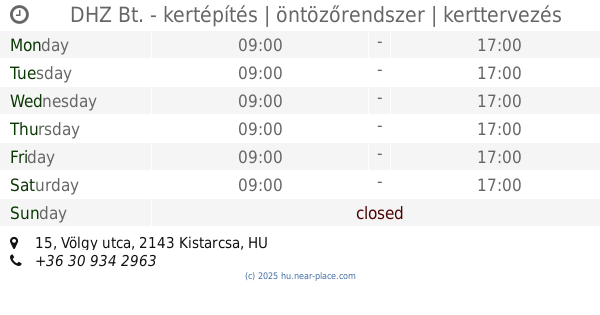
DHZ Bt. - kertépítés | öntözőrendszer | kerttervezés
Kistarcsa, Völgy utca 15
Park
read more
2.015 km
Trianoni emlékmű
Kistarcsa, Ifjúság tér 2-3
Park
read more
2.015 km
Trianon memorial
Kistarcsa, Ifjúság tér 2-3
Park
read more
2.028 km
Ifjúság tér
Kistarcsa, Ifjúság tér 1
Park
read more
2.11 km
Szent Imre Szobor
Kistarcsa, Batthyány utca 2
Park
read more
2.11 km
Szent Imre Sculpture
Kistarcsa, Batthyány utca 2
Park
read more
2.149 km
Emlékfal
Kistarcsa, Deák Ferenc utca 1
Park
read more
2.155 km
Emlékpark
Kistarcsa, Széchenyi utca 67
Park
read more
2.18 km
Székelykapu
Kistarcsa, Széchenyi utca 80
Park
read more
2.442 km
Hangulatosotthon Üzlet
Kistarcsa, 42, Szabadság út
Park
read more
3.863 km
Csömör, Bulgárkert
Csömör, Kistarcsai utca 16
Park
read more
3.996 km
Àldozataink,Első És Màsodik Vilàghàborús Emlékpark
Nagytarcsa, Rákóczi utca
Park
read more
4.805 km
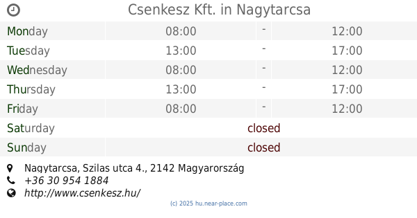
Csenkesz Kft.
Nagytarcsa, Szilas utca 4.
Park
read more
4.831 km
Gramen Kft.
Nagytarcsa, Szilas utca 4
Park
read more
5.275 km
Szent László Szobor
Mogyoród
Park
read more
5.338 km
Mogyoród Főtér
Mogyoród, Dózsa György út 2
Park
read more
5.645 km
Elizabeth Park Nature Reserve
Gödöllő, Táncsics Mihály út 68
Park
read more
5.734 km
Erzsébet park
Gödöllő
Park
read more
5.808 km
Erzsébet királyné szobra
Gödöllő
Park
read more
5.917 km
Caprera Park
XVI. kerület
Park
read more
6.235 km
Szentháromság park
Gödöllő
Park
read more
6.372 km
Cinkota Beach Gardens
Budapest
Park
read more
📑
all categories
Accounting
Administrative area level 1
Administrative area level 2
Airport
Amusement park
Aquarium
Art gallery
Atm
Bakery
Bank
Bar
Beauty salon
Bicycle store
Book store
Bowling alley
Bus station
Cafe
Campground
Car dealer
Car rental
Car repair
Car wash
Casino
Cemetery
Church
City hall
Clothing store
Colloquial area
Convenience store
Country
Courthouse
Dentist
Department store
Doctor
Electrician
Electronics store
Embassy
Finance
Fire station
Florist
Food
Funeral home
Furniture store
Gas station
General contractor
Grocery or supermarket
Gym
Hair care
Hardware store
Health
Hindu Temple
Home goods store
Hospital
Insurance agency
Intersection
Jewelry store
Laundry
Lawyer
Library
Light rail station
Liquor store
Local government office
Locality
Locksmith
Lodging
Meal delivery
Meal takeaway
Mosque
Movie rental
Movie theater
Moving company
Museum
Natural feature
Neighborhood
Night club
Painter
Park
Parking
Pet store
Pharmacy
Physiotherapist
Place of worship
Plumber
Point of interest
Police
Political
Post office
Premise
Real estate agency
Restaurant
Roofing contractor
Route
Rv park, camping
School
Shoe store
Shopping mall
Spa
Stadium
Storage
Store
Subpremise
Subway station
Supermarket
Synagogue
Taxi stand
Train station
Transit station
Travel agency
University
Veterinary care
Zoo
administrative area level 3
sublocality level 1
↑