Park nearby II. világháborús katonasír
Hungary
Park nearby II. világháborús katonasír
II. világháborús katonasír
Gánt Hungary
contacts phone
:
+36
Latitude:
47.4591623
, Longitude:
18.414816
read more
nearest Park
693 m
Szent Vendel Emlékhely
Gánt
Park
read more
1.748 km
Üdülőfalu, Vérteskozma
Gánt, Fő utca 57
Park
read more
7.362 km
Városi Sporttelep
Oroszlány, Táncsics utca 66.
Park
read more
7.554 km
Csákvári focipálya
Csákvár
Park
read more
8.156 km
Oroszlányi művüves focipálya
Oroszlány
Park
read more
10.49 km
Földtani Park
Gánt
Park
read more
10.667 km
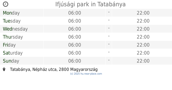
Ifjúsági park
Tatabánya, Népház utca
Park
read more
10.753 km
Bokodi Lebegő Falu
Oroszlány, Erőműi tópart
Park
read more
10.98 km
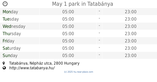
May 1 park
Tatabánya, Népház utca
Park
read more
11.136 km
Német kitelepítés emlékműve
Környe, 81323
Park
read more
11.374 km
Környei focipálya
Környe
Park
read more
12.888 km
Erőműi sportpálya
Tatabánya
Park
read more
12.924 km
Ocean Repulok Emlekhelye
Felcsút
Park
read more
13.301 km
Kisvasút
Alcsútdoboz
Park
read more
13.517 km
Csákberényi régi focipálya
Csákberény
Park
read more
13.726 km
Kresz Park
Tatabánya, Mártírok útja
Park
read more
13.908 km
Alcsúti Arboretum Nature Reserves
Alcsútdoboz, Kastély 2
Park
read more
13.908 km
Alcsúti arborétum természetvédelmi terület
Alcsútdoboz, Kastély 2
Park
read more
14.362 km
Hunyadi János tér
Tatabánya
Park
read more
14.811 km
Alcsútdobozi focipálya
Alcsútdoboz
Park
read more
14.814 km
Zámolyi focipálya
Zámoly
Park
read more
14.981 km
Aradi vértanúk tere
Tatabánya
Park
read more
15.771 km
Dadi focipálya
Dad
Park
read more
16.45 km
Csókakői focipálya
Csókakő
Park
read more
16.514 km
Jordán Parkerdő
Csókakő
Park
read more
📑
all categories
Accounting
Administrative area level 1
Administrative area level 2
Airport
Amusement park
Aquarium
Art gallery
Atm
Bakery
Bank
Bar
Beauty salon
Bicycle store
Book store
Bowling alley
Bus station
Cafe
Campground
Car dealer
Car rental
Car repair
Car wash
Casino
Cemetery
Church
City hall
Clothing store
Colloquial area
Convenience store
Country
Courthouse
Dentist
Department store
Doctor
Electrician
Electronics store
Embassy
Finance
Fire station
Florist
Food
Funeral home
Furniture store
Gas station
General contractor
Grocery or supermarket
Gym
Hair care
Hardware store
Health
Hindu Temple
Home goods store
Hospital
Insurance agency
Intersection
Jewelry store
Laundry
Lawyer
Library
Light rail station
Liquor store
Local government office
Locality
Locksmith
Lodging
Meal delivery
Meal takeaway
Mosque
Movie rental
Movie theater
Moving company
Museum
Natural feature
Neighborhood
Night club
Painter
Park
Parking
Pet store
Pharmacy
Physiotherapist
Place of worship
Plumber
Point of interest
Police
Political
Post office
Premise
Real estate agency
Restaurant
Roofing contractor
Route
Rv park, camping
School
Shoe store
Shopping mall
Spa
Stadium
Storage
Store
Subpremise
Subway station
Supermarket
Synagogue
Taxi stand
Train station
Transit station
Travel agency
University
Veterinary care
Zoo
administrative area level 3
sublocality level 1
↑