Park nearby Holdvilágárok indulás
Hungary
Park nearby Holdvilágárok indulás
Holdvilágárok indulás
311, Kiskovácsi, 2013, Pomáz, HU Ungarn
contacts phone
:
+36
Latitude:
47.665433
, Longitude:
18.9678184
larger map & directions
read more
nearest Park
1.58 km
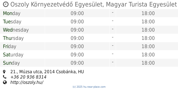
Oszoly Környezetvédő Egyesület, Magyar Turista Egyesület Csobánkai Osztálya
Csobánka, Múzsa utca 21.
Park
read more
2.358 km
Csobánkai focipálya
Csobánka
Park
read more
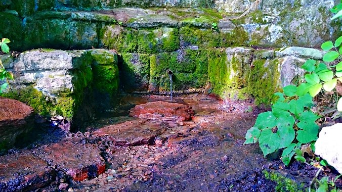
3.162 km
Csepel-forrás
Pomáz
Park
read more
3.806 km
Kerekes-kút forrás
Pomáz, 47.691021589, 18.9334098003
Park
read more
3.966 km
Pomázi Magyar Vár
Pomáz
Park
read more
4.191 km
Dera Szurdok
Csobánka
Park
read more
4.243 km
Bükki-puszta
Pilisszentlászló
Park
read more
4.321 km
UFO nyomok
Pilisszántó
Park
read more
4.511 km
Pomázi focipálya
Pomáz
Park
read more
4.692 km
Sikáros
Pomáz
Park
read more
4.703 km
Szent István Park
Pomáz, Ond utca 2
Park
read more
4.844 km
Hősök szobra
Pomáz, Hősök tere 10-12
Park
read more
5.073 km
Nagy-Kevély
Pilisborosjenő
Park
read more
6.674 km
Kisforrás park
Szentendre, Kisforrás utca 63
Park
read more
7.895 km
Global Garden Kft
Szentendre, Róka utca
Park
read more
8.305 km
Spartacus-ösvény
Visegrád
Park
read more
9.264 km
Kopasz domb
Budapest, Meggy utca 42
Park
read more
9.719 km
Forrás-park
Piliscsaba, Batthyány Lajos utca 1
Park
read more
9.849 km
Kéktúra Pecsételőhely
Nagykovácsi, Muflon utca 20
Park
read more
12.418 km
Atilla szobor
Dunakeszi, Attila utca
Park
read more
13.904 km
Budapesti Erdőgazdaság Zrt.
Budapest, Hévízi út 4/a
Park
read more
15.813 km
József Attila tér
XIII. kerület
Park
read more
15.848 km
Japánkert
Budapest, Hajós Alfréd sétány
Park
read more
15.861 km
Városháza park
Budapest Deák F. utca
Park
read more
18.931 km
Páskomliget-park
Rákospalota
Park
read more
📑
all categories
Accounting
Administrative area level 1
Administrative area level 2
Airport
Amusement park
Aquarium
Art gallery
Atm
Bakery
Bank
Bar
Beauty salon
Bicycle store
Book store
Bowling alley
Bus station
Cafe
Campground
Car dealer
Car rental
Car repair
Car wash
Casino
Cemetery
Church
City hall
Clothing store
Colloquial area
Convenience store
Country
Courthouse
Dentist
Department store
Doctor
Electrician
Electronics store
Embassy
Finance
Fire station
Florist
Food
Funeral home
Furniture store
Gas station
General contractor
Grocery or supermarket
Gym
Hair care
Hardware store
Health
Hindu Temple
Home goods store
Hospital
Insurance agency
Intersection
Jewelry store
Laundry
Lawyer
Library
Light rail station
Liquor store
Local government office
Locality
Locksmith
Lodging
Meal delivery
Meal takeaway
Mosque
Movie rental
Movie theater
Moving company
Museum
Natural feature
Neighborhood
Night club
Painter
Park
Parking
Pet store
Pharmacy
Physiotherapist
Place of worship
Plumber
Point of interest
Police
Political
Post office
Premise
Real estate agency
Restaurant
Roofing contractor
Route
Rv park, camping
School
Shoe store
Shopping mall
Spa
Stadium
Storage
Store
Subpremise
Subway station
Supermarket
Synagogue
Taxi stand
Train station
Transit station
Travel agency
University
Veterinary care
Zoo
administrative area level 3
sublocality level 1
↑