Night club nearby Víg Otthon Idősek Klubbja
Hungary
Night club nearby Víg Otthon Idősek Klubbja
Víg Otthon Idősek Klubbja
Budapest, Víg utca 18 Ungarn
contacts phone
:
+36
Latitude:
47.493791
, Longitude:
19.0735173
read more
nearest Night club
400 m
Dühöngő RageRoom
Budapest, 3, Somogyi Béla utca 1
Night club
read more
427 m
Nyuszi And Díszíti
Budapest, Rákóczi út 51
Night club
read more
549 m
Godonzò Kert
Budapest, Hungary, Vajdahunyad utca 4
Night club
read more
560 m
Ciklámen Idősek Klubja
Budapest, II. János Pál pápa tér 17
Night club
read more
621 m
Vittula
Budapest, Kertész utca 4
Night club
read more
622 m
Klub Vittula
Budapest, Kertész utca 4
Night club
read more
635 m
Corvinus Café
Budapest, Erzsébet körút 15
Night club
read more
670 m
The Box (Box) Ruin Pubs
Budapest, Klauzál utca 10
Night club
read more
748 m
Cut & Roll Fodrászat
Budapest, 1083, Baross utca 102a
Night club
read more
796 m
TERF Könyvtár
Budapest, Rákóczi út 11
Night club
read more
807 m
Hpnotiq Budapest
Budapest, 22, Dohány utca 22
Night club
read more
844 m
Harsfa Söröző
Budapest, Hársfa utca 28
Night club
read more
876 m
Őszikék Idősek Klubja
Budapest, Baross utca 109
Night club
read more
879 m
TIT Kossuth Club Association
Budapest, Múzeum utca 7
Night club
read more
879 m
TIT Kossuth Klub Egyesület
Budapest, Múzeum utca 7
Night club
read more
919 m
Party Dance Tánciskola
Budapest, Kertész utca 30
Night club
read more
951 m
Robot
Budapest, Akácfa utca 49
Night club
read more
970 m
Fogas Ház és Kert
Budapest, Akácfa utca 49-51
Night club
read more
990 m
Instant
Budapest, Akácfa utca 49-51
Night club
read more
1.002 km
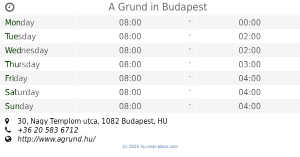
A Grund
Budapest, Nagy Templom utca 30
Night club
read more
1.027 km
Hashtag
Budapest, Kertész utca 33
Night club
read more
1.056 km
Vintage Club
Budapest, Kinizsi utca 31
Night club
read more
1.105 km
Mika kert
Budapest, Kazinczy utca 45
Night club
read more
1.176 km
Sperling Kft.
Budapest, Kazinczy utca 53
Night club
read more
1.229 km
Kuplung
Budapest, Király utca 46
Night club
read more
📑
all categories
Accounting
Administrative area level 1
Administrative area level 2
Airport
Amusement park
Aquarium
Art gallery
Atm
Bakery
Bank
Bar
Beauty salon
Bicycle store
Book store
Bowling alley
Bus station
Cafe
Campground
Car dealer
Car rental
Car repair
Car wash
Casino
Cemetery
Church
City hall
Clothing store
Colloquial area
Convenience store
Country
Courthouse
Dentist
Department store
Doctor
Electrician
Electronics store
Embassy
Finance
Fire station
Florist
Food
Funeral home
Furniture store
Gas station
General contractor
Grocery or supermarket
Gym
Hair care
Hardware store
Health
Hindu Temple
Home goods store
Hospital
Insurance agency
Intersection
Jewelry store
Laundry
Lawyer
Library
Light rail station
Liquor store
Local government office
Locality
Locksmith
Lodging
Meal delivery
Meal takeaway
Mosque
Movie rental
Movie theater
Moving company
Museum
Natural feature
Neighborhood
Night club
Painter
Park
Parking
Pet store
Pharmacy
Physiotherapist
Place of worship
Plumber
Point of interest
Police
Political
Post office
Premise
Real estate agency
Restaurant
Roofing contractor
Route
Rv park, camping
School
Shoe store
Shopping mall
Spa
Stadium
Storage
Store
Subpremise
Subway station
Supermarket
Synagogue
Taxi stand
Train station
Transit station
Travel agency
University
Veterinary care
Zoo
administrative area level 3
sublocality level 1
↑