Night club nearby titkom.COM
Hungary
Night club nearby titkom.COM
titkom.COM
Budapest, Szív utca 50 Magyarország
contacts phone
:
+36
Latitude:
47.5107264
, Longitude:
19.0660395
read more
nearest Night club
261 m
Fenomén TáncStúdió és TáncSport Egyesület
Budapest, Vörösmarty utca 65
Night club
read more
316 m
MagentaSun szolárium studio
Budapest, Andrássy út 77
Night club
read more
388 m
Magnetház
Budapest, Andrássy út 98
Night club
read more
569 m
West End City Center Tetőterasz
Budapest
Night club
read more
570 m
Hello Baby
Budapest, Andrássy út 52
Night club
read more
573 m
Remix Retro Disco
Budapest, Teréz körút 55
Night club
read more
614 m
Sabai-Sabai Traditional Thai massage
Budapest, Zichy Jenő utca 51
Night club
read more
661 m
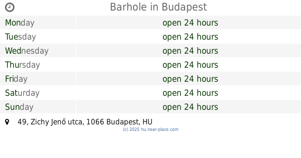
Barhole
Budapest, Zichy Jenő utca 49
Night club
read more
679 m
Vault 51 - Gamer Bar
Budapest, Ó utca 51
Night club
read more
685 m
Weinhaus Borház
Budapest, Jókai tér 7
Night club
read more
687 m
XLR Próbaterem és Stúdió
Budapest, Szabolcs utca 4
Night club
read more
774 m
C2 Bisztró & Klub
Budapest, Rottenbiller utca 39
Night club
read more
781 m
Mysterygames
Budapest, Zichy Jenő utca 39
Night club
read more
803 m
parallel szabadulószoba
Budapest, Hársfa utca 59/b
Night club
read more
814 m
Budai Tango Club
Budapest, Szondi utca 98b
Night club
read more
814 m
Budapesti Tango Club
Budapest, Szondi utca 98b
Night club
read more
865 m
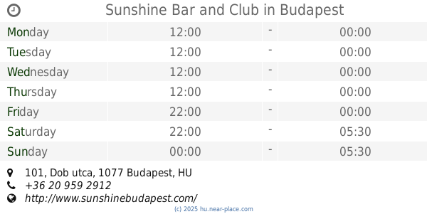
Sunshine Club and Bar
Budapest, Dob utca 101
Night club
read more
865 m
Sunshine Bar and Club
Budapest, Dob utca 101
Night club
read more
877 m
Szerelemlakat
Budapest, 9./a, Hegedű utca
Night club
read more
989 m
G-POINT Klub
Budapest, Csanády utca 11
Night club
read more
1.023 km
WarExit
Budapest, Bajcsy-Zsilinszky út 35
Night club
read more
1.081 km
Savoy Garden
Budapest, Csanády utca 16
Night club
read more
1.093 km
Pompázatos Kégli
Budapest, Hutyra Ferenc utca 14-16
Night club
read more
1.093 km
Pompázatos Kégli
Budapest, Hutyra Ferenc utca 14
Night club
read more
1.201 km
Equus-club
Budapest, István utca 2
Night club
read more
📑
all categories
Accounting
Administrative area level 1
Administrative area level 2
Airport
Amusement park
Aquarium
Art gallery
Atm
Bakery
Bank
Bar
Beauty salon
Bicycle store
Book store
Bowling alley
Bus station
Cafe
Campground
Car dealer
Car rental
Car repair
Car wash
Casino
Cemetery
Church
City hall
Clothing store
Colloquial area
Convenience store
Country
Courthouse
Dentist
Department store
Doctor
Electrician
Electronics store
Embassy
Finance
Fire station
Florist
Food
Funeral home
Furniture store
Gas station
General contractor
Grocery or supermarket
Gym
Hair care
Hardware store
Health
Hindu Temple
Home goods store
Hospital
Insurance agency
Intersection
Jewelry store
Laundry
Lawyer
Library
Light rail station
Liquor store
Local government office
Locality
Locksmith
Lodging
Meal delivery
Meal takeaway
Mosque
Movie rental
Movie theater
Moving company
Museum
Natural feature
Neighborhood
Night club
Painter
Park
Parking
Pet store
Pharmacy
Physiotherapist
Place of worship
Plumber
Point of interest
Police
Political
Post office
Premise
Real estate agency
Restaurant
Roofing contractor
Route
Rv park, camping
School
Shoe store
Shopping mall
Spa
Stadium
Storage
Store
Subpremise
Subway station
Supermarket
Synagogue
Taxi stand
Train station
Transit station
Travel agency
University
Veterinary care
Zoo
administrative area level 3
sublocality level 1
↑