Night club nearby Szápári horgásztó
Hungary
Night club nearby Szápári horgásztó
Szápári horgásztó
Szápár Hungary
contacts phone
:
+36
Latitude:
47.3167534
, Longitude:
18.0512116
read more
nearest Night club
11.523 km
Bakony Kapu Vendéglő
Balinka, Gajavölgy utca 57
Night club
read more
12.755 km
Bérhegy leszálló
Várpalota, Badacsony szőlő
Night club
read more
13.008 km
Ezerjó Horgásztó Kft.
Mór, Petőfi Sándor utca 8
Night club
read more
13.15 km
OASIS PUB MÓR
Mór, Kodály Zoltán utca 2/a
Night club
read more
13.358 km
Italbolt Ezersziget
Bodajk, Bányász lakótelep 14
Night club
read more
13.664 km
Művelődési Ház
Mór, Erzsébet tér 14
Night club
read more
14.213 km
Havanna Kávéház
Várpalota, Árpád utca
Night club
read more
14.23 km
Forgács Terasz
Várpalota, Muskotály utca
Night club
read more
14.252 km
Kóczán-pince
Mór
Night club
read more
14.969 km
The Beach
Fehérvárcsurgó, Hungary
Night club
read more
15.888 km
Totya Aqua Land
Várpalota, Tomori köz 10
Night club
read more
16.231 km
Tank vezetés Tank.hu Várpalota
Night club
read more
20.781 km
Faluház Magyaralmás
Magyaralmás, Iskola utca 5
Night club
read more
21.013 km
Kisbéri Spartacus SE Sportpálya
Kisbér, Komáromi utca 25-27
Night club
read more
24.729 km
Tűzoltó büfé
Berhida, Kiskovácsi utca 47
Night club
read more
26.911 km
Közgáz Udvar
Veszprém, Vár utca 18
Night club
read more
26.913 km
LaserBase Veszprém
Veszprém, Völgyhíd tér 1
Night club
read more
27.041 km
Buszmegálló
Oroszlány, Táncsics Mihály út 55
Night club
read more
27.138 km
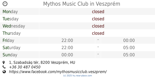
Mythos Music Club
Veszprém, Szabadság tér 1
Night club
read more
27.308 km
ÉletMagHáz
Veszprém, Dózsa György utca 23
Night club
read more
28.26 km
Kapu-Trió Kft.
Oroszlány, Takács Imre utca 33
Night club
read more
29.493 km
Úrhida Horse Association
Úrhida, 12, Pirosalma utca
Night club
read more
29.493 km
Úrhidai Lovas Egyesület
Úrhida, 12, Pirosalma utca
Night club
read more
32.224 km
Cifra Fishing
Szabadbattyán, Mártírok útja 1
Night club
read more
32.31 km
Kutyaszerviz
Szabadbattyán
Night club
read more
📑
all categories
Accounting
Administrative area level 1
Administrative area level 2
Airport
Amusement park
Aquarium
Art gallery
Atm
Bakery
Bank
Bar
Beauty salon
Bicycle store
Book store
Bowling alley
Bus station
Cafe
Campground
Car dealer
Car rental
Car repair
Car wash
Casino
Cemetery
Church
City hall
Clothing store
Colloquial area
Convenience store
Country
Courthouse
Dentist
Department store
Doctor
Electrician
Electronics store
Embassy
Finance
Fire station
Florist
Food
Funeral home
Furniture store
Gas station
General contractor
Grocery or supermarket
Gym
Hair care
Hardware store
Health
Hindu Temple
Home goods store
Hospital
Insurance agency
Intersection
Jewelry store
Laundry
Lawyer
Library
Light rail station
Liquor store
Local government office
Locality
Locksmith
Lodging
Meal delivery
Meal takeaway
Mosque
Movie rental
Movie theater
Moving company
Museum
Natural feature
Neighborhood
Night club
Painter
Park
Parking
Pet store
Pharmacy
Physiotherapist
Place of worship
Plumber
Point of interest
Police
Political
Post office
Premise
Real estate agency
Restaurant
Roofing contractor
Route
Rv park, camping
School
Shoe store
Shopping mall
Spa
Stadium
Storage
Store
Subpremise
Subway station
Supermarket
Synagogue
Taxi stand
Train station
Transit station
Travel agency
University
Veterinary care
Zoo
administrative area level 3
sublocality level 1
↑