Night club nearby RETRÓVASAK
Hungary
Night club nearby RETRÓVASAK
RETRÓVASAK
Biatorbágy, 2051, Ungarn
contacts phone
:
+36
Latitude:
47.4809415
, Longitude:
18.8330192
larger map & directions
read more
nearest Night club
692 m
Játszótér
Biatorbágy, Alkotmány utca
Night club
read more
1.771 km
Redneck Ranch
Páty, 81106
Night club
read more
3.385 km
Texas Ranch
Budakeszi, Pátyi út
Night club
read more
5.185 km
Fusion Élményközpont és Rendezvényhelyszín
Budaörs, Keleti utca 1
Night club
read more
5.185 km
Kids Fusion Experience Center
Budaörs, Keleti utca 1
Night club
read more
5.187 km
Autoexpo M1
Budaörs, Keleti utca
Night club
read more
7.132 km
Jàtszótér Viziló
Törökbálint, Bajcsy-Zsilinszky utca 56
Night club
read more
7.383 km
Quad Park Törökbálint
Törökbálint, Bajcsy-Zsilinszky utca 71
Night club
read more
8.083 km
WLACHGARTEN PINCE
Etyek, Újhegy
Night club
read more
11.489 km
Meglepkék.hu Harckocsi Vezetés
Budapest, Repülőtéri út 2
Night club
read more
11.984 km
Children's Railway modeling study group
Budapest
Night club
read more
12.445 km
Érdligeti Játszótér
Érd
Night club
read more
12.86 km
Next Stage Kft raktár
Budapest, Gyógyvíz utca
Night club
read more
13.722 km
AAA MASTER MASON BT.
Bicske, Széchenyi utca 53
Night club
read more
13.984 km
Vagon
Budapest, Rakodó utca 813
Night club
read more
14.155 km
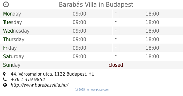
Barabás Villa
Budapest, Városmajor utca 44
Night club
read more
14.772 km
Bohem 16 - Bistro & Lounge
Budapest, Lövőház utca 16b
Night club
read more
14.807 km
Fotopoint
Budapest, Jávorka Sándor lépcső
Night club
read more
15.223 km
Jàtszótèr
Pilisszentiván, Szabadság út 120
Night club
read more
15.588 km
Játszótér
Pilisvörösvár, Görgey utca 22
Night club
read more
15.991 km
RTL Klub
Budapest, Nagytétényi út 47
Night club
read more
16.655 km
Spiritusz disc golf park
Budapest
Night club
read more
17.065 km
Campion park
Budapest, Bécsi út 302
Night club
read more
18.031 km
Oázis On Ice
Halásztelek, 2314, Hold utca
Night club
read more
18.336 km
Drift
Tököl
Night club
read more
📑
all categories
Accounting
Administrative area level 1
Administrative area level 2
Airport
Amusement park
Aquarium
Art gallery
Atm
Bakery
Bank
Bar
Beauty salon
Bicycle store
Book store
Bowling alley
Bus station
Cafe
Campground
Car dealer
Car rental
Car repair
Car wash
Casino
Cemetery
Church
City hall
Clothing store
Colloquial area
Convenience store
Country
Courthouse
Dentist
Department store
Doctor
Electrician
Electronics store
Embassy
Finance
Fire station
Florist
Food
Funeral home
Furniture store
Gas station
General contractor
Grocery or supermarket
Gym
Hair care
Hardware store
Health
Hindu Temple
Home goods store
Hospital
Insurance agency
Intersection
Jewelry store
Laundry
Lawyer
Library
Light rail station
Liquor store
Local government office
Locality
Locksmith
Lodging
Meal delivery
Meal takeaway
Mosque
Movie rental
Movie theater
Moving company
Museum
Natural feature
Neighborhood
Night club
Painter
Park
Parking
Pet store
Pharmacy
Physiotherapist
Place of worship
Plumber
Point of interest
Police
Political
Post office
Premise
Real estate agency
Restaurant
Roofing contractor
Route
Rv park, camping
School
Shoe store
Shopping mall
Spa
Stadium
Storage
Store
Subpremise
Subway station
Supermarket
Synagogue
Taxi stand
Train station
Transit station
Travel agency
University
Veterinary care
Zoo
administrative area level 3
sublocality level 1
↑