Night club nearby Presszó, Dohánybolt
Hungary
Night club nearby Presszó, Dohánybolt
Presszó, Dohánybolt
Dávod, Dózsa György utca 58 Hungary
contacts phone
:
+36
Latitude:
45.9966667
, Longitude:
18.9123007
read more
nearest Night club
10.065 km
Bácska Tamburazenekar
Gara, Hunyadi János utca 25
Night club
read more
15.016 km
Sas Rezidencia
Dunaszekcső, Fenyő utca 8
Night club
read more
17.208 km
Sètáló Utca
Mohács, Szabadság utca 22
Night club
read more
19.824 km
Kiserdő Kalandpark
Baja, Május 1. sétány 12
Night club
read more
19.824 km
Small Forest Adventure Park
Baja, Május 1. sétány 12
Night club
read more
20.09 km
Wiking Club
Baja, Attila utca 16
Night club
read more
20.148 km
Petofi Island
Baja, Tóth Kálmán utca 5
Night club
read more
20.148 km
Petőfi Sziget
Baja, Tóth Kálmán utca 5
Night club
read more
20.459 km
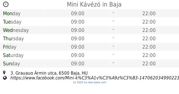
Mini Kávézó
Baja, Grauaug Ármin utca 3
Night club
read more
20.54 km
Belvárosi Közösségi Ház
Baja, Széchenyi István utca
Night club
read more
20.541 km
Víziszínpad
Sugovica
Night club
read more
21.072 km
Vol.1. Club
Baja, Kölcsey Ferenc utca 25
Night club
read more
21.351 km
Dunaparti Tanyacsárda Vendégház
Budapest, 6500 I. Tanya, Beniczky Tamás utca 7
Night club
read more
21.567 km
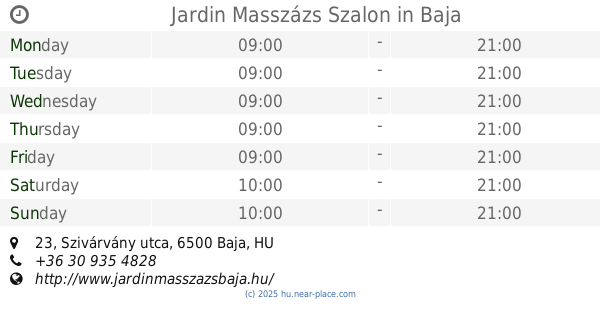
Jardin Masszázs Szalon
Baja, Szivárvány utca 23
Night club
read more
22.083 km
Békavár
Baja, II. számú tanya 5
Night club
read more
22.465 km
Kéktó
Baja
Night club
read more
22.747 km
Dunaparti Tanyacsárda Vendégház
Baja, Unnamed Road,
Night club
read more
31.718 km
Mórágyi Rög
Mórágy, Szabadság utca 66
Night club
read more
43.816 km
Gesztenye Söröző
Szekszárd, Rákóczi utca 52
Night club
read more
46.216 km
Óbánya Mecsek túra
Óbánya
Night club
read more
50.346 km
Club Insomnia
Siklós, Szent István tér 8
Night club
read more
50.849 km
Szászvári lövész egylet
Szászvár, Unnamed Road,7349
Night club
read more
56.61 km
Disco "Best Of"
Kunfehértó, Tábor utca
Night club
read more
61.284 km
Szauron tornya
Kiskunhalas
Night club
read more
63.932 km
Rendezvénytér
Nagyhajmás, 7343
Night club
read more
📑
all categories
Accounting
Administrative area level 1
Administrative area level 2
Airport
Amusement park
Aquarium
Art gallery
Atm
Bakery
Bank
Bar
Beauty salon
Bicycle store
Book store
Bowling alley
Bus station
Cafe
Campground
Car dealer
Car rental
Car repair
Car wash
Casino
Cemetery
Church
City hall
Clothing store
Colloquial area
Convenience store
Country
Courthouse
Dentist
Department store
Doctor
Electrician
Electronics store
Embassy
Finance
Fire station
Florist
Food
Funeral home
Furniture store
Gas station
General contractor
Grocery or supermarket
Gym
Hair care
Hardware store
Health
Hindu Temple
Home goods store
Hospital
Insurance agency
Intersection
Jewelry store
Laundry
Lawyer
Library
Light rail station
Liquor store
Local government office
Locality
Locksmith
Lodging
Meal delivery
Meal takeaway
Mosque
Movie rental
Movie theater
Moving company
Museum
Natural feature
Neighborhood
Night club
Painter
Park
Parking
Pet store
Pharmacy
Physiotherapist
Place of worship
Plumber
Point of interest
Police
Political
Post office
Premise
Real estate agency
Restaurant
Roofing contractor
Route
Rv park, camping
School
Shoe store
Shopping mall
Spa
Stadium
Storage
Store
Subpremise
Subway station
Supermarket
Synagogue
Taxi stand
Train station
Transit station
Travel agency
University
Veterinary care
Zoo
administrative area level 3
sublocality level 1
↑