Night club nearby Izgő-Mozgó Játszósarok
Hungary
Night club nearby Izgő-Mozgó Játszósarok
Izgő-Mozgó Játszósarok
68, Szent István út, 2370, Dabas, HU Magyarország
contacts phone
:
+36 20 237 7498
Latitude:
47.1801269
, Longitude:
19.3150143
larger map & directions
read more
nearest Night club
1.185 km
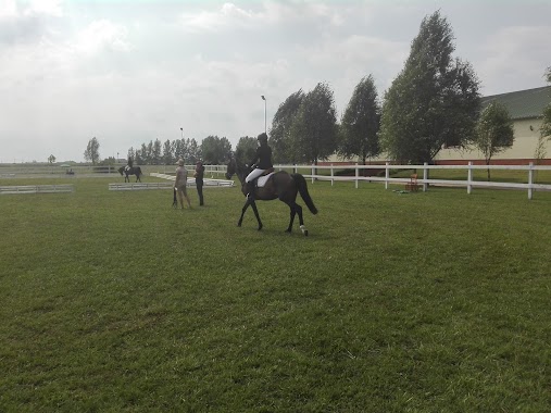
Jakab Lovasudvar
Dabas, Andrássy utca 83
Night club
read more
4.575 km
HCC-ho Start
Dabas, Mánteleki út
Night club
read more
8.654 km
Sport Presszó
Inárcs, József utca 1
Night club
read more
11.255 km
Mohl Tanya és Lovasfarm
Bugyi
Night club
read more
11.605 km
Dávid Söröző Lottózó
Újlengyel, 47., Kossuth Lajos utca 45
Night club
read more
11.758 km
Napköziotthonos Óvoda
Újlengyel, Petőfi Sándor utca 5
Night club
read more
12.539 km
Rácz Tanya
Ócsa
Night club
read more
13.231 km
Equina lovasfarm
Ócsa
Night club
read more
14.799 km
Kóhalma Vadásztársaság
Alsónémedi
Night club
read more
18.29 km
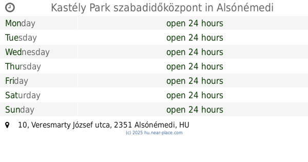
Kastély Park szabadidőközpont
Alsónémedi, Veresmarty József utca 10
Night club
read more
18.559 km
Esztikéék
Felsőpakony, Arany János utca 34
Night club
read more
18.585 km
A skorpió odú
Felsőlajos, Iskola utca 30
Night club
read more
18.684 km
Otthon Felsőlajos
Felsőlajos
Night club
read more
19.587 km
Délegyháza Bogi tó
Délegyháza
Night club
read more
19.964 km
Zandi Andika Beni Gyurma
Délegyháza
Night club
read more
23.135 km
Üllői focipálya
Üllő, Dóra Sándor körút 47
Night club
read more
23.775 km
Major József Pincéje
Monor
Night club
read more
24.093 km
Játszótér
Dunaharaszti, Knézich utca 24
Night club
read more
26.078 km
Tököli Parkerdő
Tököl, Unnamed Road
Night club
read more
26.299 km
A Kacsák Mellett
Majosháza, Széchenyi sétány 47
Night club
read more
26.785 km
Civilház (Integrált Közösségi és Szolgáltató Tér)
Gomba, Kossuth Lajos tér 4
Night club
read more
27.742 km
Miklós Pláza
Szigetszentmiklós
Night club
read more
30.532 km
Csepeli Modellreptér
Szigetszentmiklós
Night club
read more
30.673 km
Pünkösdhalmi Tó
Szigetszentmiklós
Night club
read more
31.547 km
Oázis On Ice
Halásztelek, 2314, Hold utca
Night club
read more
📑
all categories
Accounting
Administrative area level 1
Administrative area level 2
Airport
Amusement park
Aquarium
Art gallery
Atm
Bakery
Bank
Bar
Beauty salon
Bicycle store
Book store
Bowling alley
Bus station
Cafe
Campground
Car dealer
Car rental
Car repair
Car wash
Casino
Cemetery
Church
City hall
Clothing store
Colloquial area
Convenience store
Country
Courthouse
Dentist
Department store
Doctor
Electrician
Electronics store
Embassy
Finance
Fire station
Florist
Food
Funeral home
Furniture store
Gas station
General contractor
Grocery or supermarket
Gym
Hair care
Hardware store
Health
Hindu Temple
Home goods store
Hospital
Insurance agency
Intersection
Jewelry store
Laundry
Lawyer
Library
Light rail station
Liquor store
Local government office
Locality
Locksmith
Lodging
Meal delivery
Meal takeaway
Mosque
Movie rental
Movie theater
Moving company
Museum
Natural feature
Neighborhood
Night club
Painter
Park
Parking
Pet store
Pharmacy
Physiotherapist
Place of worship
Plumber
Point of interest
Police
Political
Post office
Premise
Real estate agency
Restaurant
Roofing contractor
Route
Rv park, camping
School
Shoe store
Shopping mall
Spa
Stadium
Storage
Store
Subpremise
Subway station
Supermarket
Synagogue
Taxi stand
Train station
Transit station
Travel agency
University
Veterinary care
Zoo
administrative area level 3
sublocality level 1
↑