Night club nearby Fesztivál Park
Hungary
Night club nearby Fesztivál Park
Fesztivál Park
Tarján Magyarország
contacts phone
:
+36
Latitude:
47.609241
, Longitude:
18.509065
read more
nearest Night club
2.235 km
Német Nemzetiségi Ifjúsági Tábor
Tarján
Night club
read more
4.428 km
Diófa Söröző
Héreg, Petőfi Sándor utca 15
Night club
read more
8.496 km
Kis Casa Söröző
Tatabánya, 2800
Night club
read more
8.722 km
Játszótér
Tatabánya, Mártírok útja 9
Night club
read more
8.743 km
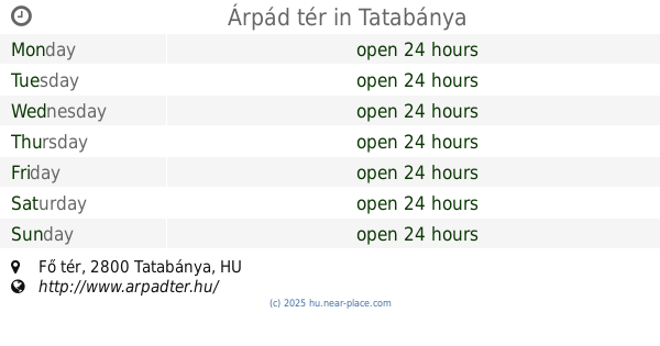
Árpád tér
Tatabánya, Fő tér
Night club
read more
8.771 km
Aranykutya Söröző
Tatabánya, Szent Borbála tér 4
Night club
read more
8.949 km
Békepipa Club és Étterem
Tatabánya, Sárberki ltp. 3852 hrsz, 2800
Night club
read more
8.963 km
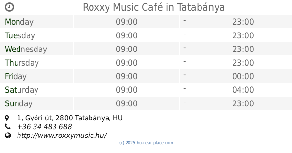
Roxxy Music Café
Tatabánya, 1, A,, Győri út 1
Night club
read more
9.408 km
Miller Pub
Tatabánya, Dózsakert utca 52
Night club
read more
9.774 km
Bánhida tanszék
Tatabánya, Madách Imre utca 1
Night club
read more
9.867 km
Taszi Garden
Tatabánya, Szigeti dűlő 145
Night club
read more
9.972 km
Nexus Biliárd
Vértesszőlős, Valusek Dezső utca 51
Night club
read more
9.972 km
Nexus Billiards
Vértesszőlős, Valusek Dezső utca 51
Night club
read more
10.737 km
CimBoróka tér
Tatabánya, Boróka utca
Night club
read more
11.208 km
X-Elite zenekar
Tatabánya, Búzavirág utca
Night club
read more
15.08 km
Óbarok Kertivasút
Óbarok, Fő utca 67
Night club
read more
15.534 km
Vala Háza
Környe, Ságvári Endre utca 28
Night club
read more
15.566 km
Kriska Pincészet
Mogyorósbánya
Night club
read more
16.229 km
City Söröző és Diszkó
Bicske, Szent István út 26
Night club
read more
17.004 km
Barna Medve
Tokod, Táti utca 30
Night club
read more
17.571 km
AAA MASTER MASON BT.
Bicske, Széchenyi utca 53
Night club
read more
18.624 km
Puding Söröző
Tokod, József Attila utca 123
Night club
read more
19.088 km
Kapu-Trió Kft.
Oroszlány, Takács Imre utca 33
Night club
read more
19.896 km
Faház Sörözö
Tokodaltáró, Akácos út 1 Mihály u. 41-59
Night club
read more
20.328 km
Buszmegálló
Oroszlány, Táncsics Mihály út 55
Night club
read more
📑
all categories
Accounting
Administrative area level 1
Administrative area level 2
Airport
Amusement park
Aquarium
Art gallery
Atm
Bakery
Bank
Bar
Beauty salon
Bicycle store
Book store
Bowling alley
Bus station
Cafe
Campground
Car dealer
Car rental
Car repair
Car wash
Casino
Cemetery
Church
City hall
Clothing store
Colloquial area
Convenience store
Country
Courthouse
Dentist
Department store
Doctor
Electrician
Electronics store
Embassy
Finance
Fire station
Florist
Food
Funeral home
Furniture store
Gas station
General contractor
Grocery or supermarket
Gym
Hair care
Hardware store
Health
Hindu Temple
Home goods store
Hospital
Insurance agency
Intersection
Jewelry store
Laundry
Lawyer
Library
Light rail station
Liquor store
Local government office
Locality
Locksmith
Lodging
Meal delivery
Meal takeaway
Mosque
Movie rental
Movie theater
Moving company
Museum
Natural feature
Neighborhood
Night club
Painter
Park
Parking
Pet store
Pharmacy
Physiotherapist
Place of worship
Plumber
Point of interest
Police
Political
Post office
Premise
Real estate agency
Restaurant
Roofing contractor
Route
Rv park, camping
School
Shoe store
Shopping mall
Spa
Stadium
Storage
Store
Subpremise
Subway station
Supermarket
Synagogue
Taxi stand
Train station
Transit station
Travel agency
University
Veterinary care
Zoo
administrative area level 3
sublocality level 1
↑