places in Mako
Hungary
Mako
Mako
Administrative Region:
Csongrad
population:
22 390
calling code:
+36-62
postcode:
6900
Location on the map of Hungary
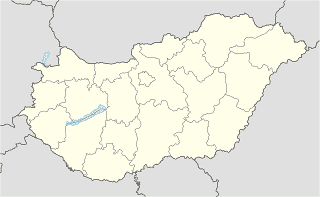
Mako
Car rental
wedding&party limuzin
Makó, Szent A.u.22.
Car rental
read more
Car repair
UNIX Makó
Makó, Deák Ferenc utca 61
Car repair
read more
Gumicentrum
Makó, Aradi utca 115
Car repair
read more
Regál Autósbolt
Makó, Csanád vezér tér 13
Car repair
read more
Lőkös Gumiszerviz Taubrich and Lőkös Bt.
Makó, Szegedi utca 27
Car repair
read more
Autó Univerzál Kft.
Makó, Justh Gyula utca 67
Car repair
read more
Lőkös Gumiszerviz Taubrich és Lőkös Bt.
Makó, Szegedi utca 27
Car repair
read more
Pap Sándor Autószerelő
Makó, Kelemen László utca 25
Car repair
read more
Kúsz Pál Autóvillamossági Szerviz
Makó, Szent Anna utca 10
Car repair
read more
Bárdi Autó Makó
Makó, Aradi utca 62
Car repair
read more
Bárdi Autó
Makó, Aradi utca 62
Car repair
read more
Csapó Csaba Háztartási gépszerelés
Makó, Bajza utca 12
Car repair
read more
Rozsnyai Autoszerviz
Makó, Gőzmalom utca 1
Car repair
read more
Cemetery
Makói temető
Makó
Cemetery
read more
Sírkert utcai temető
Makó
Cemetery
read more
Batthyány utcai temető
Makó
Cemetery
read more
Csongrád megyei Kegyeleti Kft.
Makó, Verebes utca 2
Cemetery
read more
Kálvária utcai temető
Makó
Cemetery
read more
KARDOS Temetkezés
Makó, Kígyó utca 18
Cemetery
read more
Pozsonyi utcai temető
Makó
Cemetery
read more
Jewish Cemetery
Makó
Cemetery
read more
Church
Szent László templom
Makó, Vásárhelyi utca
Church
read more
Belvárosi Szent István király templom
Makó, Pázmány utca
Church
read more
Makói baptista gyülekezet
Makó, Megyeház utca
Church
read more
Evangelical Church
Makó, Vásárhelyi út 25
Church
read more
Evangélikus templom
Makó, Vásárhelyi út 25
Church
read more
Makó-Újvárosi Református Egyházközség temploma
Makó, Vásárhelyi utca
Church
read more
City hall
Makói Polgármesteri Hivatal
Makó, Széchenyi tér 22
City hall
read more
Mako Mayor's Office
Makó, Széchenyi tér 22
City hall
read more
📑
Mako all categories
Accounting
Administrative area level 2
Atm
Bakery
Bank
Bar
Beauty salon
Bicycle store
Book store
Bus station
Cafe
Campground
Car rental
Car repair
Cemetery
Church
City hall
Clothing store
Convenience store
Courthouse
Dentist
Doctor
Electrician
Electronics store
Finance
Fire station
Florist
Food
Furniture store
Gas station
General contractor
Grocery or supermarket
Gym
Hair care
Hardware store
Health
Home goods store
Hospital
Insurance agency
Jewelry store
Laundry
Library
Locality
Lodging
Meal delivery
Moving company
Museum
Natural feature
Neighborhood
Night club
Park
Parking
Pharmacy
Place of worship
Point of interest
Police
Post office
Premise
Real estate agency
Restaurant
Roofing contractor
Route
School
Shopping mall
Spa
Storage
Store
Supermarket
Synagogue
Train station
Transit station
Travel agency
Veterinary care
sublocality level 1
↑