Lodging nearby ózon camping
Hungary
Lodging nearby ózon camping
ózon camping
3, Erdei Malom köz, 9400, Sopron, HU Węgry
contacts phone
:
+36
Latitude:
47.67832
, Longitude:
16.5405894
larger map & directions
read more
nearest Lodging
754 m
Karmelita Boutique Apartman
Sopron, Malompatak utca 8
Lodging
read more
847 m
Sopron Monastery Retreat Centre
Sopron, Kolostorhegy utca 2
Lodging
read more
1.245 km
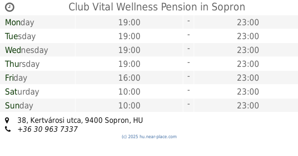
Club Vital Wellness Pension
Sopron, Kertvárosi utca 38
Lodging
read more
1.245 km
Club Vital Wellness Panzió
Sopron, Kertvárosi utca 38
Lodging
read more
1.658 km
Cyclamen Chalets
Sopron, Várkerület 75
Lodging
read more
1.871 km
Fenyves Üdülő, Paksi Atomerőmű Zrt.
Sopron, Fenyves sor 10
Lodging
read more
1.937 km
Ciklámen Faházak
Sopron, Várkerület 75
Lodging
read more
2.052 km
Trimmel Alpine Guest House
Sopron, Felsőlövér út 25
Lodging
read more
2.152 km
Sopron Apartman
Sopron, 1, Cseresznye sor Fsz
Lodging
read more
2.283 km
Hotel Fagus
Sopron, Ojtózi utca 3
Lodging
read more
2.322 km
Füzi Panzió
Sopron, Deákkúti út 10
Lodging
read more
2.51 km
Solar Club Hotel
Hungary
Lodging
read more
2.596 km
B&B Villa Mimi
Sopron, Honvéd út 5
Lodging
read more
2.596 km
Villa Mimi
Sopron, Honvéd út 5
Lodging
read more
2.66 km
Mandarin Panzió
Sopron, Baross út 1
Lodging
read more
2.699 km
Machatsek Gyula Diákhotel és Kollégium
Sopron, Baross út 4
Lodging
read more
2.712 km
Fieszta hotel
Sopron, Lőver körút 37
Lodging
read more
2.714 km
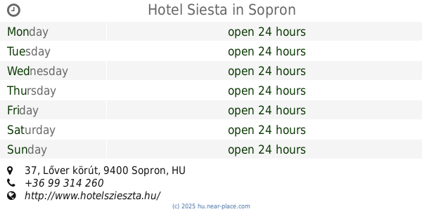
Hotel Siesta
Sopron, Lőver körút 37
Lodging
read more
2.783 km
Adorján Vendégház
Sopron, Faludi Ferenc utca 2
Lodging
read more
2.932 km
Bausz Haus
Sopron, Béke út 1
Lodging
read more
2.936 km
Vadvirág Hotel & Restaurant
Ágfalva, Magyar utca 25.
Lodging
read more
2.948 km
STUDIO 16
Sopron, Ősz utca 5
Lodging
read more
2.997 km
*** Superior Hotel Lover
Sopron, Várisi út 4
Lodging
read more
2.997 km
Hotel Lövér***superior, Sopron
Sopron, Várisi út 4
Lodging
read more
2.997 km
Hotel Lövér***superior
Sopron, Várisi út 4
Lodging
read more
📑
all categories
Accounting
Administrative area level 1
Administrative area level 2
Airport
Amusement park
Aquarium
Art gallery
Atm
Bakery
Bank
Bar
Beauty salon
Bicycle store
Book store
Bowling alley
Bus station
Cafe
Campground
Car dealer
Car rental
Car repair
Car wash
Casino
Cemetery
Church
City hall
Clothing store
Colloquial area
Convenience store
Country
Courthouse
Dentist
Department store
Doctor
Electrician
Electronics store
Embassy
Finance
Fire station
Florist
Food
Funeral home
Furniture store
Gas station
General contractor
Grocery or supermarket
Gym
Hair care
Hardware store
Health
Hindu Temple
Home goods store
Hospital
Insurance agency
Intersection
Jewelry store
Laundry
Lawyer
Library
Light rail station
Liquor store
Local government office
Locality
Locksmith
Lodging
Meal delivery
Meal takeaway
Mosque
Movie rental
Movie theater
Moving company
Museum
Natural feature
Neighborhood
Night club
Painter
Park
Parking
Pet store
Pharmacy
Physiotherapist
Place of worship
Plumber
Point of interest
Police
Political
Post office
Premise
Real estate agency
Restaurant
Roofing contractor
Route
Rv park, camping
School
Shoe store
Shopping mall
Spa
Stadium
Storage
Store
Subpremise
Subway station
Supermarket
Synagogue
Taxi stand
Train station
Transit station
Travel agency
University
Veterinary care
Zoo
administrative area level 3
sublocality level 1
↑