Gym nearby VasgyuróGym
Hungary
Gym nearby VasgyuróGym
VasgyuróGym
Cegléd, Kőrösi út Magyarország
contacts phone
:
+36
Latitude:
47.1538996
, Longitude:
19.7895356
read more
nearest Gym
1.228 km
Claudia Szabadidő Központ
Cegléd, Várkonyi István utca 49
Gym
read more
1.828 km
Sagaku Sportklub (Fegyenc terem)
Cegléd, Mérleg utca
Gym
read more
1.84 km
Sagaku Sportklub (Malom terem)
Cegléd, Mérleg utca
Gym
read more
1.855 km
Sagaku Sportklub
Cegléd, Árpád utca
Gym
read more
2.945 km
Pulzus Szabadidőközpont
Cegléd, Összekötő út 30
Gym
read more
3.356 km
Városi Sportpálya
Cegléd, Malomtó szél 36
Gym
read more
5.081 km
Nyársapáti Motorcrosspálya
Nyársapát, Ugyeri út
Gym
read more
12.727 km
Csemő-Hantháza MX Track
Csemő, Új Élet dűlő 7
Gym
read more
14.402 km
Kovács Roland
Nagykőrös, 2750, Gubody utca 2
Gym
read more
17.389 km
Grizzly Fitness Center
Albertirsa, Iskola utca 18
Gym
read more
20.433 km
Road 311 Fitness
Tápiószele, Bartók Béla út 19
Gym
read more
20.89 km
Sportcsarnok és Tanuszoda
Tápiószentmárton, Bartók Béla út 5/A
Gym
read more
22.572 km
Mizse K1 Klub
Lajosmizse, Dózsa György út 84
Gym
read more
22.879 km
Kung-fu
Kecskemét, Úrrét tanya 78
Gym
read more
23.48 km
Platán Fitness Stúdió - Pilis
Pilis, Rákóczi út 14
Gym
read more
24.319 km
Familyoga
Pilis, Eperfa u. 1. 2721
Gym
read more
28.658 km
Monorierdő Focipálya
Monorierdő, Unnamed Road
Gym
read more
32.97 km
SAMbarzHungary Workout Park
Tiszakécske, Wesselényi utca 35
Gym
read more
33.74 km
Csúcs Forma Fittness
Kerekegyháza, Hunyadi utca 2
Gym
read more
33.832 km
Csendom Gym
Kerekegyháza, Farkas János utca 25
Gym
read more
42.968 km
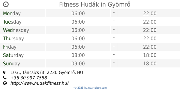
Fitness Hudák
Gyömrő, 1. emelet, Táncsics út 103.
Gym
read more
57.06 km
Leung Ting Wing Tsun Kung-fu Iskola (18. kerület)
Budapest, Lakatos út 30
Gym
read more
60.048 km
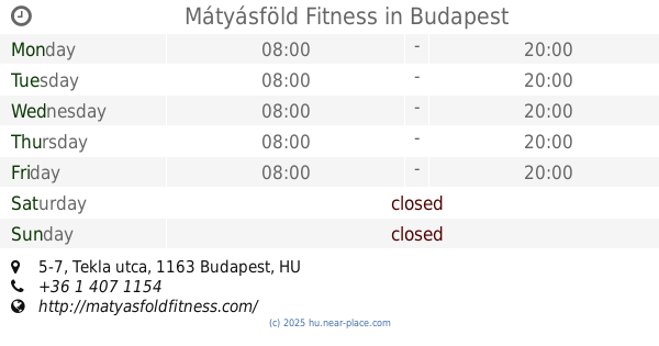
Mátyásföld Fitness
Budapest, Tekla utca 5-7
Gym
read more
60.065 km
Merkapt Maraton Sportközpont
Budapest, Maglódi út 12a
Gym
read more
60.238 km
Focipálya
Gödöllő, Gödöllői Sportcentrum
Gym
read more
📑
all categories
Accounting
Administrative area level 1
Administrative area level 2
Airport
Amusement park
Aquarium
Art gallery
Atm
Bakery
Bank
Bar
Beauty salon
Bicycle store
Book store
Bowling alley
Bus station
Cafe
Campground
Car dealer
Car rental
Car repair
Car wash
Casino
Cemetery
Church
City hall
Clothing store
Colloquial area
Convenience store
Country
Courthouse
Dentist
Department store
Doctor
Electrician
Electronics store
Embassy
Finance
Fire station
Florist
Food
Funeral home
Furniture store
Gas station
General contractor
Grocery or supermarket
Gym
Hair care
Hardware store
Health
Hindu Temple
Home goods store
Hospital
Insurance agency
Intersection
Jewelry store
Laundry
Lawyer
Library
Light rail station
Liquor store
Local government office
Locality
Locksmith
Lodging
Meal delivery
Meal takeaway
Mosque
Movie rental
Movie theater
Moving company
Museum
Natural feature
Neighborhood
Night club
Painter
Park
Parking
Pet store
Pharmacy
Physiotherapist
Place of worship
Plumber
Point of interest
Police
Political
Post office
Premise
Real estate agency
Restaurant
Roofing contractor
Route
Rv park, camping
School
Shoe store
Shopping mall
Spa
Stadium
Storage
Store
Subpremise
Subway station
Supermarket
Synagogue
Taxi stand
Train station
Transit station
Travel agency
University
Veterinary care
Zoo
administrative area level 3
sublocality level 1
↑