Gym nearby Nyílegyenes Íjász Club
Hungary
Gym nearby Nyílegyenes Íjász Club
Nyílegyenes Íjász Club
Kunszentmiklós, Kecskeméti utca 48 Węgry
contacts phone
:
+36
Latitude:
47.0212204
, Longitude:
19.1415779
read more
nearest Gym
1.373 km
Miklóssy János Sport Center
Kunszentmiklós, Szent Erzsébet tér 5
Gym
read more
1.373 km
Miklóssy János Sportközpont
Kunszentmiklós, Szent Erzsébet tér 5
Gym
read more
8.431 km
Tassi tornaterem
Tass, Dunai út 5
Gym
read more
16.175 km
MG Sportcentrum
Rácalmás, Venyimi út 9
Gym
read more
16.175 km
MG Sportcenter
Rácalmás, Venyimi út 9
Gym
read more
16.567 km
Orchidea Szépségszalon
Dunaújváros, Vasmű út 67
Gym
read more
16.698 km
Shaolin Kungfu Association Hungary Dunaújváros, SKAH Duna Se
Dunaújváros, Római körút 51
Gym
read more
17.035 km
Dóra TRX Gym
Dunaújváros, Béke tér
Gym
read more
17.048 km
Fedora Fitness Center
Dunaújváros, Táncsics Mihály utca 6
Gym
read more
17.156 km
Best Body Gym
Dunaújváros, Béke tér 3
Gym
read more
18.188 km
Box Klub
Dunaújváros
Gym
read more
18.465 km
Dunaújváros Lőtér
Dunaújváros, Tűzálló út 5
Gym
read more
20.511 km
Elite Gym
Ráckeve, Dömsödi út 34
Gym
read more
21.099 km
Phesziraz Fitt
Ráckeve, Vörösmarty utca 1
Gym
read more
21.222 km
Profi Fitness
Kiskunlacháza, Rákóczi út 13
Gym
read more
21.517 km
Fitt lesz
Dabas, Kossuth Lajos út 49
Gym
read more
22.07 km
Várdai Fitness Centrum
Dabas, Déli Szabó Károly utca 11
Gym
read more
22.07 km
Várdai Fitness Center
Dabas, Déli Szabó Károly utca 11
Gym
read more
22.261 km
Dabas Infrashape
Dabas, Szent István út 23
Gym
read more
22.793 km
garka testműhely
Dabas, Bem utca 94
Gym
read more
23.833 km
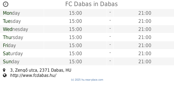
FC Dabas
Dabas, Zengő utca 3
Gym
read more
25.9 km
Csendom Gym
Kerekegyháza, Farkas János utca 25
Gym
read more
27.053 km
Zr Team Fülöpháza
Fülöpháza, Petőfi utca 1
Gym
read more
28.737 km
Bowling és Fitness
Újhartyán, Pipacs út 35
Gym
read more
28.993 km
Izsáki Sports hall
Izsák, Csokonai utca 16
Gym
read more
📑
all categories
Accounting
Administrative area level 1
Administrative area level 2
Airport
Amusement park
Aquarium
Art gallery
Atm
Bakery
Bank
Bar
Beauty salon
Bicycle store
Book store
Bowling alley
Bus station
Cafe
Campground
Car dealer
Car rental
Car repair
Car wash
Casino
Cemetery
Church
City hall
Clothing store
Colloquial area
Convenience store
Country
Courthouse
Dentist
Department store
Doctor
Electrician
Electronics store
Embassy
Finance
Fire station
Florist
Food
Funeral home
Furniture store
Gas station
General contractor
Grocery or supermarket
Gym
Hair care
Hardware store
Health
Hindu Temple
Home goods store
Hospital
Insurance agency
Intersection
Jewelry store
Laundry
Lawyer
Library
Light rail station
Liquor store
Local government office
Locality
Locksmith
Lodging
Meal delivery
Meal takeaway
Mosque
Movie rental
Movie theater
Moving company
Museum
Natural feature
Neighborhood
Night club
Painter
Park
Parking
Pet store
Pharmacy
Physiotherapist
Place of worship
Plumber
Point of interest
Police
Political
Post office
Premise
Real estate agency
Restaurant
Roofing contractor
Route
Rv park, camping
School
Shoe store
Shopping mall
Spa
Stadium
Storage
Store
Subpremise
Subway station
Supermarket
Synagogue
Taxi stand
Train station
Transit station
Travel agency
University
Veterinary care
Zoo
administrative area level 3
sublocality level 1
↑