Gym nearby minitraining
Hungary
Gym nearby minitraining
minitraining
12/E, Petőfi telep, 2142, Nagytarcsa, HU Magyarország
contacts phone
:
+36
website:
minitraining.hu
Latitude:
47.523611
, Longitude:
19.2925849
larger map & directions
read more
nearest Gym
274 m
minitraining
Nagytarcsa, Petőfi telep 12
Gym
read more
711 m
Nagytarcsai Pump Track
Nagytarcsa, Sport utca
Gym
read more
2.825 km
Aktív Sport Farm
Budapest, Kis Károshíd utca
Gym
read more
3.289 km
Street workout pálya
Kistarcsa, Széchenyi utca 75
Gym
read more
3.411 km
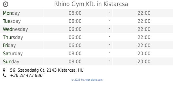
Rhino Gym Kft.
Kistarcsa, Szabadság út 56
Gym
read more
3.411 km
Rhino Ltd. Gym.
Kistarcsa, Szabadság út 56
Gym
read more
3.492 km
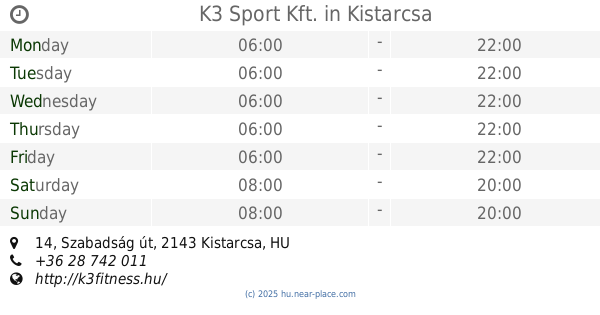
K3 Sport Kft.
Kistarcsa, Szabadság út 14
Gym
read more
3.521 km
Mayafitness
Kistarcsa, Hunyadi utca 28
Gym
read more
3.721 km
BúvárBenő babaúszás
Kerepes, Szabadság út 100
Gym
read more
3.726 km
Royal Station, Sport-, Szabadidő- és Rendezvényközpont
Kerepes, Szabadság út 102/B
Gym
read more
3.726 km
Royal Station Sports and Leisure Center
Kerepes, Szabadság út 102/B
Gym
read more
4.353 km
Classic Body Power Gym & Fitness Gym
Budapest, Péceli út 156
Gym
read more
4.477 km
Alma Mozgásközpont
Budapest, X. utca 4
Gym
read more
4.486 km
Alma Mozgásközpont
Budapest, Hősök tere 18
Gym
read more
4.494 km
Alma Mozgásközpont
Budapest, X. utca 2
Gym
read more
4.497 km
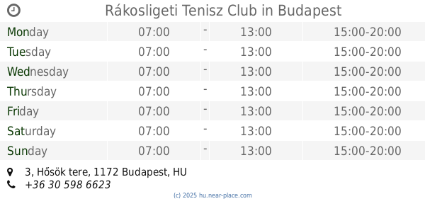
Rákosligeti Tenisz Club
Budapest, Hősök tere 3
Gym
read more
4.573 km
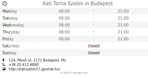
Kati Torna Szalon
Budapest, Péceli út 124
Gym
read more
4.573 km
Kati Fitness
Budapest, Péceli út 124
Gym
read more
4.814 km
Péceli Mozgásműhely
Pécel, Fűzfa utca 1
Gym
read more
5.157 km
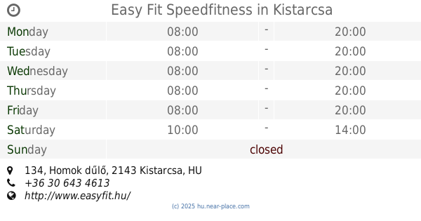
Easy Fit Speedfitness
Kistarcsa, Homok dűlő 134
Gym
read more
5.454 km
KMG
Budapest, Vanília utca 7
Gym
read more
5.74 km
Kínai Gerinctorna - WuShuang DaoYin - Félegyházi Balázs
Pécel, Maglódi út 12. Pekáry kastély
Gym
read more
5.769 km
Lakótelepi Játszótér
Budapest, Pesti út 155
Gym
read more
5.974 km
Szattva Jógastúdió
Budapest, Pesti út 41c
Gym
read more
6.227 km
teszt1
Budapest, Pesti út
Gym
read more
📑
all categories
Accounting
Administrative area level 1
Administrative area level 2
Airport
Amusement park
Aquarium
Art gallery
Atm
Bakery
Bank
Bar
Beauty salon
Bicycle store
Book store
Bowling alley
Bus station
Cafe
Campground
Car dealer
Car rental
Car repair
Car wash
Casino
Cemetery
Church
City hall
Clothing store
Colloquial area
Convenience store
Country
Courthouse
Dentist
Department store
Doctor
Electrician
Electronics store
Embassy
Finance
Fire station
Florist
Food
Funeral home
Furniture store
Gas station
General contractor
Grocery or supermarket
Gym
Hair care
Hardware store
Health
Hindu Temple
Home goods store
Hospital
Insurance agency
Intersection
Jewelry store
Laundry
Lawyer
Library
Light rail station
Liquor store
Local government office
Locality
Locksmith
Lodging
Meal delivery
Meal takeaway
Mosque
Movie rental
Movie theater
Moving company
Museum
Natural feature
Neighborhood
Night club
Painter
Park
Parking
Pet store
Pharmacy
Physiotherapist
Place of worship
Plumber
Point of interest
Police
Political
Post office
Premise
Real estate agency
Restaurant
Roofing contractor
Route
Rv park, camping
School
Shoe store
Shopping mall
Spa
Stadium
Storage
Store
Subpremise
Subway station
Supermarket
Synagogue
Taxi stand
Train station
Transit station
Travel agency
University
Veterinary care
Zoo
administrative area level 3
sublocality level 1
↑