Gym nearby BodyGames Playground
Hungary
Gym nearby BodyGames Playground
BodyGames Playground
Budapest, Fehérvári út 120 Magyarország
contacts phone
:
+36
Latitude:
47.4569845
, Longitude:
19.0419565
read more
nearest Gym
119 m
CrossFit Újbuda
Budapest, Barázda utca 1
Gym
read more
135 m
Amazon Futballaréna
Budapest, Galvani utca 2
Gym
read more
398 m
Ventura fitness
Budapest, Fehérvári út 179
Gym
read more
436 m
Gyógytorna
Budapest, Bikszádi utca 6
Gym
read more
481 m
A Fitness
Budapest, Nándorfejérvári út 40a
Gym
read more
486 m
PowerBuilder HQ
Budapest, Nándorfejérvári út 40/a
Gym
read more
490 m
Thor Gym
Budapest, Nándorfejérvári út 40
Gym
read more
507 m
Curves - Újbuda
Budapest, Fehérvári út 160
Gym
read more
572 m
A Fitness Újbuda
Budapest, Nándorfejérvári út 40
Gym
read more
619 m
Szabadtéri kondi park
Budapest, Albert utca 45
Gym
read more
663 m
Head Squash Club
Budapest, Budafoki út 183
Gym
read more
716 m
Beast Arena § University Boxing Club
Budapest, Hengermalom út 19-21 (Új Buda Center)
Gym
read more
720 m
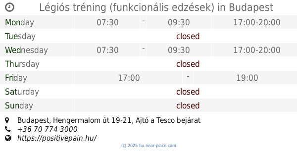
Légiós tréning (funkcionális edzések)
Budapest, Hengermalom út 19-21, Ajtó a Tesco bejárat mellett
Gym
read more
886 m
VIDA Fitness Budapest
Budapest, Petzvál József utca 46-48
Gym
read more
899 m
Vida Fitness Center
Budapest, Fehérvári út 87
Gym
read more
918 m
Balance Torna Center
Budapest, Gyapot utca 9
Gym
read more
1.011 km
EuroTechnika Kft
Budapest, Hungary, Hunyadi János út 3
Gym
read more
1.039 km
Gold Center for Education and Sports Center
Budapest, Budafoki út 113
Gym
read more
1.039 km
Gold Center Oktatási és sport központ
Budapest, Budafoki út 113
Gym
read more
1.097 km
KissLife Fitness & Gym
Budapest, Tétényi út 63. I emelet
Gym
read more
1.157 km
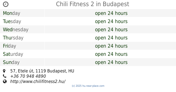
Chili Fitness 2
Budapest, Etele út 57
Gym
read more
1.709 km
Mega Fitness Buda
Budapest, Igmándi utca 1
Gym
read more
1.857 km
PULSE Power Plate Mozgásstúdió
Budapest, Fehérvári út 27
Gym
read more
1.995 km
Mikes Teniszklub
Budapest, Őrmezei út 30
Gym
read more
2.374 km
Hotel Rubin
Budapest, Dayka Gábor utca 3
Gym
read more
📑
all categories
Accounting
Administrative area level 1
Administrative area level 2
Airport
Amusement park
Aquarium
Art gallery
Atm
Bakery
Bank
Bar
Beauty salon
Bicycle store
Book store
Bowling alley
Bus station
Cafe
Campground
Car dealer
Car rental
Car repair
Car wash
Casino
Cemetery
Church
City hall
Clothing store
Colloquial area
Convenience store
Country
Courthouse
Dentist
Department store
Doctor
Electrician
Electronics store
Embassy
Finance
Fire station
Florist
Food
Funeral home
Furniture store
Gas station
General contractor
Grocery or supermarket
Gym
Hair care
Hardware store
Health
Hindu Temple
Home goods store
Hospital
Insurance agency
Intersection
Jewelry store
Laundry
Lawyer
Library
Light rail station
Liquor store
Local government office
Locality
Locksmith
Lodging
Meal delivery
Meal takeaway
Mosque
Movie rental
Movie theater
Moving company
Museum
Natural feature
Neighborhood
Night club
Painter
Park
Parking
Pet store
Pharmacy
Physiotherapist
Place of worship
Plumber
Point of interest
Police
Political
Post office
Premise
Real estate agency
Restaurant
Roofing contractor
Route
Rv park, camping
School
Shoe store
Shopping mall
Spa
Stadium
Storage
Store
Subpremise
Subway station
Supermarket
Synagogue
Taxi stand
Train station
Transit station
Travel agency
University
Veterinary care
Zoo
administrative area level 3
sublocality level 1
↑