Gas station nearby Széplaki Kft
Hungary
Gas station nearby Széplaki Kft
Széplaki Kft
Derecske, Köztársaság út 38 Hungary
contacts phone
:
+36
Latitude:
47.3599568
, Longitude:
21.5777268
read more
nearest Gas station
7.64 km
Hajdúszovát Benzinkút
Hajdúszovát
Gas station
read more
11.175 km
MAXILine Töltőállomás
Mikepércs, Debreceni utca 23
Gas station
read more
11.208 km
J und J Kft
Mikepércs, Debreceni utca 23
Gas station
read more
11.817 km
MOL Benzinkút
Hosszúpályi, Földvár utca 1/a
Gas station
read more
13.834 km
Tisztató Kft.
Ebes
Gas station
read more
14.513 km
Hajdúszoboszló Vasúti Lefejtő
Hajdúszoboszló
Gas station
read more
15.898 km
Propán 93 Szerelő-Gyártó Kft.
Hajdúszoboszló, Szováti út 4
Gas station
read more
16.089 km
OMV
Hajdúszoboszló, Hóvirág utca 2
Gas station
read more
16.214 km
MOL Benzinkút
Hajdúszoboszló, Debreceni út
Gas station
read more
16.214 km
MOL
Hajdúszoboszló, Debreceni út
Gas station
read more
17.186 km
MOL
Debrecen, Mikepércsi út 2
Gas station
read more
17.446 km
Shell
Debrecen, István út 124
Gas station
read more
17.487 km
MOL Gas station
Debrecen, Mikepércsi út I. (kimenő)
Gas station
read more
18.174 km
MAXILine Töltőállomás
Debrecen, Diószegi útca 3-5
Gas station
read more
18.185 km
MaxiLine - J und J Töltőállomás
Debrecen
Gas station
read more
18.553 km
Maxi Line Kft
Debrecen, Csákány utca 2
Gas station
read more
18.913 km
MOL Benzinkút
Debrecen, Nyugati utca 6
Gas station
read more
19.668 km
Shell
Debrecen, Böszörményi út 1
Gas station
read more
19.751 km
MOL Gas station
Debrecen, Benedek Elek tér
Gas station
read more
20.461 km
OMV Töltőállomás
Debrecen, Füredi út 27
Gas station
read more
20.893 km
Maxiline Töltőállomás
Debrecen, Balmazújvárosi út 40
Gas station
read more
21.945 km
OMV Töltőállomás
Debrecen, Kassai u 92
Gas station
read more
22.221 km
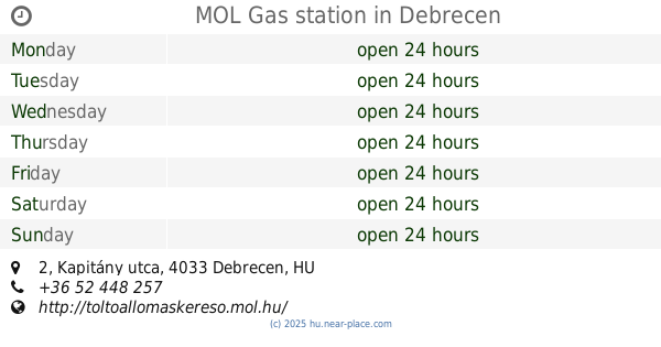
MOL Gas station
Debrecen, Kapitány utca 2
Gas station
read more
23.304 km
MOL Benzinkút
Debrecen, Böszörményi út
Gas station
read more
30.358 km
MOL Benzinkút
Vámospércs, Debreceni utca
Gas station
read more
📑
all categories
Accounting
Administrative area level 1
Administrative area level 2
Airport
Amusement park
Aquarium
Art gallery
Atm
Bakery
Bank
Bar
Beauty salon
Bicycle store
Book store
Bowling alley
Bus station
Cafe
Campground
Car dealer
Car rental
Car repair
Car wash
Casino
Cemetery
Church
City hall
Clothing store
Colloquial area
Convenience store
Country
Courthouse
Dentist
Department store
Doctor
Electrician
Electronics store
Embassy
Finance
Fire station
Florist
Food
Funeral home
Furniture store
Gas station
General contractor
Grocery or supermarket
Gym
Hair care
Hardware store
Health
Hindu Temple
Home goods store
Hospital
Insurance agency
Intersection
Jewelry store
Laundry
Lawyer
Library
Light rail station
Liquor store
Local government office
Locality
Locksmith
Lodging
Meal delivery
Meal takeaway
Mosque
Movie rental
Movie theater
Moving company
Museum
Natural feature
Neighborhood
Night club
Painter
Park
Parking
Pet store
Pharmacy
Physiotherapist
Place of worship
Plumber
Point of interest
Police
Political
Post office
Premise
Real estate agency
Restaurant
Roofing contractor
Route
Rv park, camping
School
Shoe store
Shopping mall
Spa
Stadium
Storage
Store
Subpremise
Subway station
Supermarket
Synagogue
Taxi stand
Train station
Transit station
Travel agency
University
Veterinary care
Zoo
administrative area level 3
sublocality level 1
↑