Gas station nearby MOL
Coronavirus disease (COVID-19) Situation
confirmed cases
2230232
deaths
49048
Hungary
Gas station nearby MOL
MOL
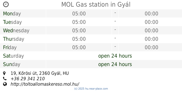
Gyál, Kőrösi út 19 Magyarország
contacts phone
:
+36
Latitude:
47.377505
, Longitude:
19.219641
read more
nearest Gas station
MOL Gas station
Gyál, Kőrösi út 19
Gas station
read more
2.516 km
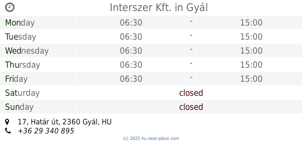
Interszer Kft.
Gyál, Határ út 17
Gas station
read more
2.539 km
M. Petrol
Gyál, M5 Gyál-Alsónémedi lehajtó, 4602
Gas station
read more
2.539 km
Mobil Petrol - Gyál
Gyál, M5 Gyál-Alsónémedi lehajtó
Gas station
read more
3.24 km
OMV
Vecsés, Gyáli út 20-22.
Gas station
read more
3.24 km
OMV Töltőállomás
Vecsés, Gyáli út 20-22.
Gas station
read more
4.468 km
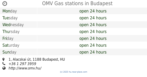
OMV Gas stations
Budapest, Alacskai út 1
Gas station
read more
4.468 km
OMV Töltőállomás
Budapest, Alacskai út 1
Gas station
read more
4.499 km
EcoPont
Vecsés, Lőrinci utca 130
Gas station
read more
4.531 km
Magán
Vecsés, Lőrinci utca 130
Gas station
read more
4.736 km
MOL Benzinkút
Vecsés, M0 II. (bal)
Gas station
read more
4.829 km
MOL benzinkút
Vecsés, 90471
Gas station
read more
4.842 km
MOL Benzinkút
Vecsés, M0 I. (jobb)
Gas station
read more
5.05 km
MOL Benzinkút
Vecsés, Fő út
Gas station
read more
5.05 km
MOL
Vecsés, Fő út
Gas station
read more
5.18 km
Shell
Vecsés, M4, Fő út 244
Gas station
read more
5.191 km
Shell
Vecsés, Fő út 4
Gas station
read more
5.193 km
Shell
Vecsés, Fő út
Gas station
read more
5.428 km
Ferihegy szakaszolóállomás
Vecsés
Gas station
read more
6.33 km
SPAR Express OMV
Budapest, Nagykőrösi út 349
Gas station
read more
6.349 km
Auchan Töltőállomás
Budapest, Bevásárló utca
Gas station
read more
6.349 km
Auchan
Budapest, Bevásárló utca
Gas station
read more
6.349 km
Auchan Benzinkút Soroksár
Budapest, Bevásárló utca
Gas station
read more
11.905 km
OIL!
Maglód, 2234, Liszt Ferenc utca 6
Gas station
read more
16.323 km
MOL
Budapest, Prielle Kornélia utca 25
Gas station
read more
📑
all categories
Accounting
Administrative area level 1
Administrative area level 2
Airport
Amusement park
Aquarium
Art gallery
Atm
Bakery
Bank
Bar
Beauty salon
Bicycle store
Book store
Bowling alley
Bus station
Cafe
Campground
Car dealer
Car rental
Car repair
Car wash
Casino
Cemetery
Church
City hall
Clothing store
Colloquial area
Convenience store
Country
Courthouse
Dentist
Department store
Doctor
Electrician
Electronics store
Embassy
Finance
Fire station
Florist
Food
Funeral home
Furniture store
Gas station
General contractor
Grocery or supermarket
Gym
Hair care
Hardware store
Health
Hindu Temple
Home goods store
Hospital
Insurance agency
Intersection
Jewelry store
Laundry
Lawyer
Library
Light rail station
Liquor store
Local government office
Locality
Locksmith
Lodging
Meal delivery
Meal takeaway
Mosque
Movie rental
Movie theater
Moving company
Museum
Natural feature
Neighborhood
Night club
Painter
Park
Parking
Pet store
Pharmacy
Physiotherapist
Place of worship
Plumber
Point of interest
Police
Political
Post office
Premise
Real estate agency
Restaurant
Roofing contractor
Route
Rv park, camping
School
Shoe store
Shopping mall
Spa
Stadium
Storage
Store
Subpremise
Subway station
Supermarket
Synagogue
Taxi stand
Train station
Transit station
Travel agency
University
Veterinary care
Zoo
administrative area level 3
sublocality level 1
↑