Gas station nearby MOL Benzinkút
Hungary
Gas station nearby MOL Benzinkút
MOL Benzinkút
Tiszakécske, Szolnoki út Hungary
contacts phone
:
+36
Latitude:
46.93825
, Longitude:
20.09723
read more
nearest Gas station
1.485 km
Kis Benzinkút
Tiszakécske, Szabolcska Mihály utca 89
Gas station
read more
10.193 km
Mocza Benzinkút
Lakitelek, Széchenyi körút
Gas station
read more
11.03 km
Benzinkút
Lakitelek, Széchenyi körút 138
Gas station
read more
11.03 km
Magán - Lakitelek
Lakitelek, Széchenyi körút 156
Gas station
read more
11.749 km
Mol Töltőallomás
Cserkeszőlő, Beton út
Gas station
read more
13.255 km
Mol - Lakitelek
Lakitelek, 44-es fõút
Gas station
read more
13.255 km
MOL Benzinkút
Lakitelek
Gas station
read more
13.255 km
MOL
Lakitelek
Gas station
read more
13.255 km
MOL Benzinkút
Lakitelek, 44-es fõút
Gas station
read more
13.921 km
Magán - Csépa
Csépa, Béke u. 239/hrsz.
Gas station
read more
14.141 km
Lukoil
Tiszaföldvár, Kunszentmártoni út 1
Gas station
read more
14.265 km
KÉRI OIL
Szentkirály
Gas station
read more
15.403 km
Inter Auto Trans Kft.
Tiszaalpár, Dózsa György utca 69/a
Gas station
read more
15.419 km
Benzinkút
Tiszaalpár, Dózsa György utca 64
Gas station
read more
15.44 km
Époil Kft
Kocsér, Szabadság utca
Gas station
read more
17.108 km
MOL
Martfű, Földvári út 4
Gas station
read more
17.733 km
Mobil Petrol
Tószeg, Várkonyi út 1
Gas station
read more
18.759 km
Benzinkút
Tiszaalpár, 4625 200
Gas station
read more
22.033 km
Gulyas Sped Ltd.
Szolnok, Simon Ferenc utca 48
Gas station
read more
23.261 km
AVIA Benzinkút
Öcsöd, Deák Ferenc út 2
Gas station
read more
24.478 km
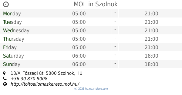
MOL
Szolnok, Tószegi út 18/A
Gas station
read more
25.098 km
OMV
Csongrád, Fő utca 65
Gas station
read more
25.844 km
Auchan gas station
Szolnok, Felső Szandai rét 1
Gas station
read more
25.844 km
Auchan benzinkút
Szolnok, Felső Szandai rét 1
Gas station
read more
26.402 km
OMV Töltőállomás
Nagykőrös, Ceglédi út 256
Gas station
read more
📑
all categories
Accounting
Administrative area level 1
Administrative area level 2
Airport
Amusement park
Aquarium
Art gallery
Atm
Bakery
Bank
Bar
Beauty salon
Bicycle store
Book store
Bowling alley
Bus station
Cafe
Campground
Car dealer
Car rental
Car repair
Car wash
Casino
Cemetery
Church
City hall
Clothing store
Colloquial area
Convenience store
Country
Courthouse
Dentist
Department store
Doctor
Electrician
Electronics store
Embassy
Finance
Fire station
Florist
Food
Funeral home
Furniture store
Gas station
General contractor
Grocery or supermarket
Gym
Hair care
Hardware store
Health
Hindu Temple
Home goods store
Hospital
Insurance agency
Intersection
Jewelry store
Laundry
Lawyer
Library
Light rail station
Liquor store
Local government office
Locality
Locksmith
Lodging
Meal delivery
Meal takeaway
Mosque
Movie rental
Movie theater
Moving company
Museum
Natural feature
Neighborhood
Night club
Painter
Park
Parking
Pet store
Pharmacy
Physiotherapist
Place of worship
Plumber
Point of interest
Police
Political
Post office
Premise
Real estate agency
Restaurant
Roofing contractor
Route
Rv park, camping
School
Shoe store
Shopping mall
Spa
Stadium
Storage
Store
Subpremise
Subway station
Supermarket
Synagogue
Taxi stand
Train station
Transit station
Travel agency
University
Veterinary care
Zoo
administrative area level 3
sublocality level 1
↑