Gas station nearby MOL Benzinkút
Hungary
Gas station nearby MOL Benzinkút
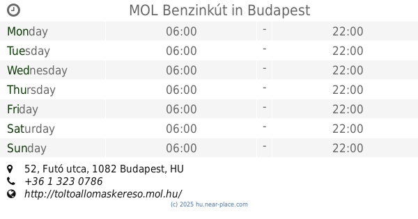
MOL Benzinkút
Golgota tér, 1089, Budapest, HU Magyarország
contacts phone
:
+36 1 323 0098
website:
toltoallomaskereso.mol.hu
Latitude:
47.486058
, Longitude:
19.093163
larger map & directions
read more
nearest Gas station
290 m
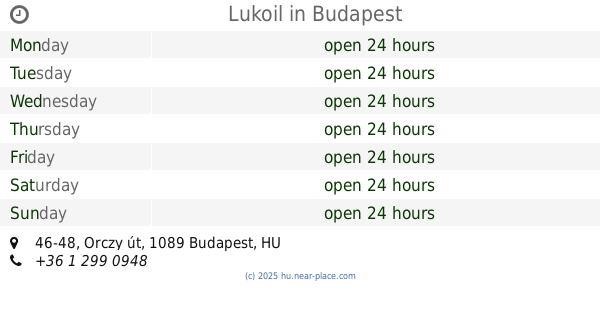
Lukoil
Budapest, Orczy út 46-48
Gas station
read more
586 m
Shell
Budapest, Kálvária tér
Gas station
read more
966 m
OMV Töltőállomás
Budapest, Könyves Kálmán körút 76
Gas station
read more
966 m
OMV
Budapest, Könyves Kálmán körút 76
Gas station
read more
1.022 km
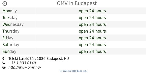
OMV
Budapest, Teleki László tér
Gas station
read more
1.022 km
OMV Töltőállomás
Budapest, Teleki László tér
Gas station
read more
1.108 km
Mol - Budapest - Könyves K. krt.
Budapest, Könyves Kálmán körút 41
Gas station
read more
1.108 km
MOL
Budapest, Könyves Kálmán körút 41
Gas station
read more
1.326 km
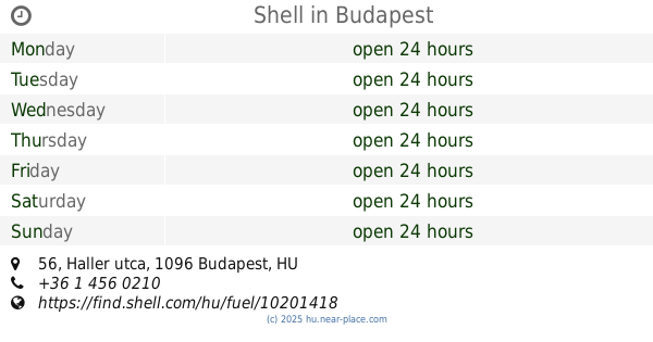
Shell
Budapest, Haller utca 56
Gas station
read more
1.396 km
MOL Benzinkút
Budapest, Futó utca 52
Gas station
read more
1.542 km
MOL Benzinkút
Budapest, Kerepesi út 5
Gas station
read more
1.597 km
MOL Benzinkút
Budapest, Hős utca 9
Gas station
read more
1.597 km
MOL Gas station
Budapest, Hős utca 9
Gas station
read more
1.671 km
Főgáz gázkút
Budapest, Salgótarjáni utca
Gas station
read more
1.682 km
OMV Töltőállomás
Budapest, Kerepesi út 22
Gas station
read more
1.812 km
Shell
Budapest, Könyves Kálmán körút 24
Gas station
read more
1.935 km
OMV
Budapest, Üllői út 137
Gas station
read more
1.935 km
OMV Töltőállomás
Budapest, Üllői út 137
Gas station
read more
1.964 km
OMV Töltőállomás
Budapest, Üllői út 110
Gas station
read more
2.06 km
OMV
Budapest, Mester utca 89
Gas station
read more
2.06 km
OMV Töltőállomás
Budapest, Mester utca 89
Gas station
read more
2.096 km
Shell
Budapest, Stefánia út 1-5
Gas station
read more
2.139 km
Lukoil
Budapest
Gas station
read more
2.14 km
Motor és Lengés Csillapitó Szerviz
Budapest, Máriássy utca 3
Gas station
read more
2.204 km
Shell
Budapest, Kerepesi út 42-46
Gas station
read more
📑
all categories
Accounting
Administrative area level 1
Administrative area level 2
Airport
Amusement park
Aquarium
Art gallery
Atm
Bakery
Bank
Bar
Beauty salon
Bicycle store
Book store
Bowling alley
Bus station
Cafe
Campground
Car dealer
Car rental
Car repair
Car wash
Casino
Cemetery
Church
City hall
Clothing store
Colloquial area
Convenience store
Country
Courthouse
Dentist
Department store
Doctor
Electrician
Electronics store
Embassy
Finance
Fire station
Florist
Food
Funeral home
Furniture store
Gas station
General contractor
Grocery or supermarket
Gym
Hair care
Hardware store
Health
Hindu Temple
Home goods store
Hospital
Insurance agency
Intersection
Jewelry store
Laundry
Lawyer
Library
Light rail station
Liquor store
Local government office
Locality
Locksmith
Lodging
Meal delivery
Meal takeaway
Mosque
Movie rental
Movie theater
Moving company
Museum
Natural feature
Neighborhood
Night club
Painter
Park
Parking
Pet store
Pharmacy
Physiotherapist
Place of worship
Plumber
Point of interest
Police
Political
Post office
Premise
Real estate agency
Restaurant
Roofing contractor
Route
Rv park, camping
School
Shoe store
Shopping mall
Spa
Stadium
Storage
Store
Subpremise
Subway station
Supermarket
Synagogue
Taxi stand
Train station
Transit station
Travel agency
University
Veterinary care
Zoo
administrative area level 3
sublocality level 1
↑