Food nearby Isagasztro kft.
Hungary
Food nearby Isagasztro kft.
Isagasztro kft.
Isaszeg, Szentgyörgypuszta Magyarország
contacts phone
:
+36
Latitude:
47.52401
, Longitude:
19.4390004
read more
nearest Food
6.973 km
Aranyponty Zrt gödöllői telephelye
Gödöllő, Malomtó utca 1
Food
read more
7.755 km
Agráció Kft.
Gödöllő, Isaszegi út 166
Food
read more
7.92 km
Két-Kata Kft.
Dány, Zöld utca 20
Food
read more
8.405 km
Gourmethoney Kft
Gödöllő, Esze Tamás utca 7
Food
read more
10.485 km
Csikósfarm
Mende
Food
read more
11.059 km
Gyömrő Gyöngye ásványvízüzem
Gyömrő, Szent István út 87
Food
read more
11.144 km
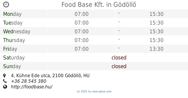
Food Base Kft.
Gödöllő, Kühne Ede utca 4
Food
read more
11.149 km
Maglód Projekt Kft.
Maglód, Fő utca 12
Food
read more
11.59 km
Dzsungel Pizzéria
Gyömrő, Táncsics Mihály utca 102
Food
read more
11.605 km
Reketye brewery
Nagytarcsa
Food
read more
11.803 km
Agrovia Kft.
Gödöllő, Balassi Bálint utca 28
Food
read more
12.883 km
Hambi büfé
Bag
Food
read more
12.968 km
Novaparty Catering Kft.
Kerepes, Nyárfa utca 12
Food
read more
13.253 km
Bevilija KFT
Budapest, Strázsahegyi dűlő 7
Food
read more
13.419 km
HoliSnacks
Budapest, Tápiógyörgye utca 5
Food
read more
13.432 km
Geér Pince
Péteri
Food
read more
13.472 km
Illés Cukrászda
Kistarcsa, Thököly út 3
Food
read more
13.614 km
Óhegy Borház
Péteri
Food
read more
14.799 km
Alba-Vit Kft
Tura, Rákóczi Ferenc út 108
Food
read more
15.172 km
Aha-Cat Kft.
Szada, Margita utca 56/F
Food
read more
16.001 km
Mikrotherm Kft.
Budapest, Ferihegyi út 292
Food
read more
16.804 km
Dr. Juice The Fruit Factory
Budapest
Food
read more
17.236 km
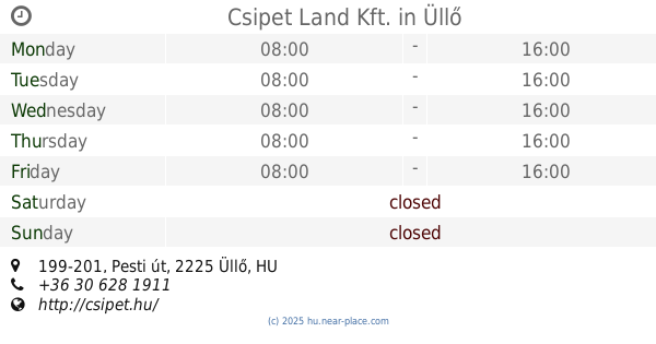
Csipet Land Kft.
Üllő, Pesti út 199-201
Food
read more
18.593 km
Gastland Kft
Vecsés
Food
read more
18.725 km
Synergytech Kft
Veresegyház, Patak köz 6
Food
read more
📑
all categories
Accounting
Administrative area level 1
Administrative area level 2
Airport
Amusement park
Aquarium
Art gallery
Atm
Bakery
Bank
Bar
Beauty salon
Bicycle store
Book store
Bowling alley
Bus station
Cafe
Campground
Car dealer
Car rental
Car repair
Car wash
Casino
Cemetery
Church
City hall
Clothing store
Colloquial area
Convenience store
Country
Courthouse
Dentist
Department store
Doctor
Electrician
Electronics store
Embassy
Finance
Fire station
Florist
Food
Funeral home
Furniture store
Gas station
General contractor
Grocery or supermarket
Gym
Hair care
Hardware store
Health
Hindu Temple
Home goods store
Hospital
Insurance agency
Intersection
Jewelry store
Laundry
Lawyer
Library
Light rail station
Liquor store
Local government office
Locality
Locksmith
Lodging
Meal delivery
Meal takeaway
Mosque
Movie rental
Movie theater
Moving company
Museum
Natural feature
Neighborhood
Night club
Painter
Park
Parking
Pet store
Pharmacy
Physiotherapist
Place of worship
Plumber
Point of interest
Police
Political
Post office
Premise
Real estate agency
Restaurant
Roofing contractor
Route
Rv park, camping
School
Shoe store
Shopping mall
Spa
Stadium
Storage
Store
Subpremise
Subway station
Supermarket
Synagogue
Taxi stand
Train station
Transit station
Travel agency
University
Veterinary care
Zoo
administrative area level 3
sublocality level 1
↑