Dentist nearby Dentist's office
Coronavirus disease (COVID-19) Situation
confirmed cases
2230232
deaths
49048
Hungary
Dentist nearby Dentist's office
Dentist's office
Biharugra, Bölönyi utca 2 Hungary
contacts phone
:
+36
Latitude:
46.9693929
, Longitude:
21.5974746
read more
nearest Dentist
38.095 km
Dentist's office
Pocsaj, Rákóczi utca 23
Dentist
read more
39.019 km
Dentist's office
Konyár, Rákóczi utca 26
Dentist
read more
39.019 km
Fogorvosi Rendelő
Konyár, Rákóczi utca 26
Dentist
read more
41.843 km
Pedro-Dent Bt.
Békés, Petőfi Sándor utca 97
Dentist
read more
42.053 km
Fogorvosi Rendelő
Békés, Vásárszél utca 2
Dentist
read more
42.053 km
Dentist's office
Békés, Vásárszél utca 2
Dentist
read more
42.81 km
Dr. Kocsondi Erika
Gyula, Kenyérsütő utca 33
Dentist
read more
43.308 km
Meto-Dent Bt.
Gyula, part utca 17
Dentist
read more
43.836 km
Centro-Dentale Kft.
Gyula, Béke sugárút 2
Dentist
read more
44.157 km
Orbital Dental Fogtechnikai Laboratórium
Gyula, Szent István utca 27/b
Dentist
read more
49.324 km
Top Dent Fogtechnikai Kkt.
Békéscsaba, Bocskai utca 4
Dentist
read more
49.65 km
Kerekes Dental
Békéscsaba, Lencsési út 26
Dentist
read more
49.683 km
KEEP-DENT Fogászati és Kereskedelmi Bt.
Békéscsaba, Fövenyes utca 13
Dentist
read more
49.929 km
Teleki-Dent Kft.
Békéscsaba, Andrássy út 4
Dentist
read more
49.962 km
Dr. Sárkány Kálmán, fogorvos
Békéscsaba, Munkácsy utca 1
Dentist
read more
49.97 km
Dr. Mihályfi Adrienne fogorvos
Békéscsaba, Munkácsy utca 1
Dentist
read more
50.044 km
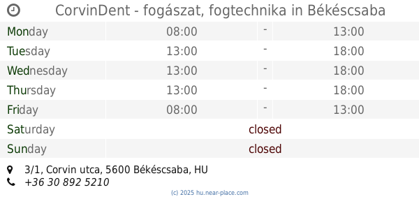
CorvinDent - fogászat, fogtechnika
Békéscsaba, Corvin utca 3/1
Dentist
read more
50.061 km
Déko-Dent Bt.
Békéscsaba, Kinizsi utca 7
Dentist
read more
50.34 km
Smilepoint Corner Studio
Békéscsaba, Luther utca 28
Dentist
read more
50.489 km
Center Fogászat
Békéscsaba, Andrássy út 43
Dentist
read more
50.672 km
Körös Fogászati Központ
Békéscsaba, Andrássy út 51/a
Dentist
read more
51.1 km
Fogászat
Létavértes, Kossuth utca 6
Dentist
read more
52.469 km
König Fogászat
Békéscsaba, Kolozsvári utca
Dentist
read more
📑
all categories
Accounting
Administrative area level 1
Administrative area level 2
Airport
Amusement park
Aquarium
Art gallery
Atm
Bakery
Bank
Bar
Beauty salon
Bicycle store
Book store
Bowling alley
Bus station
Cafe
Campground
Car dealer
Car rental
Car repair
Car wash
Casino
Cemetery
Church
City hall
Clothing store
Colloquial area
Convenience store
Country
Courthouse
Dentist
Department store
Doctor
Electrician
Electronics store
Embassy
Finance
Fire station
Florist
Food
Funeral home
Furniture store
Gas station
General contractor
Grocery or supermarket
Gym
Hair care
Hardware store
Health
Hindu Temple
Home goods store
Hospital
Insurance agency
Intersection
Jewelry store
Laundry
Lawyer
Library
Light rail station
Liquor store
Local government office
Locality
Locksmith
Lodging
Meal delivery
Meal takeaway
Mosque
Movie rental
Movie theater
Moving company
Museum
Natural feature
Neighborhood
Night club
Painter
Park
Parking
Pet store
Pharmacy
Physiotherapist
Place of worship
Plumber
Point of interest
Police
Political
Post office
Premise
Real estate agency
Restaurant
Roofing contractor
Route
Rv park, camping
School
Shoe store
Shopping mall
Spa
Stadium
Storage
Store
Subpremise
Subway station
Supermarket
Synagogue
Taxi stand
Train station
Transit station
Travel agency
University
Veterinary care
Zoo
administrative area level 3
sublocality level 1
↑