Cemetery nearby Katolikus temető
Hungary
Cemetery nearby Katolikus temető
Katolikus temető
Méhész utca, 2000, Szentendre, HU Ungarn
contacts phone
:
+36
Latitude:
47.6734862
, Longitude:
19.0750861
larger map & directions
read more
nearest Cemetery
70 m
Izraelita temető
Szentendre, 3684 hrsz., Hold utca
Cemetery
read more
854 m
Sztradovai úti temető
Szentendre
Cemetery
read more
1.438 km
Pilisi utcai temető
Szentendre
Cemetery
read more
2.024 km
INTERWORK Temetkezési Kft.
Szentendre, Szentlászlói út 152
Cemetery
read more
2.086 km
Madách téri temető
Szigetmonostor
Cemetery
read more
2.119 km
Szigetmonostori Temető
Szigetmonostor
Cemetery
read more
3.049 km
Zrínyi utcai temető
Szigetmonostor
Cemetery
read more
3.049 km
Temető
Szigetmonostor, Zrínyi utca 6
Cemetery
read more
3.663 km
Kisállat temető
Dunakeszi, Csobogó köz 6
Cemetery
read more
4.023 km
Pázmány Péter utcai temető
Alsógöd
Cemetery
read more
4.408 km
Régi temető
Pomáz
Cemetery
read more
4.455 km
Szent István Király Templom Úrnatemető
Göd, Nagy László esperes tér
Cemetery
read more
4.456 km
Új temető
Pomáz
Cemetery
read more
4.501 km
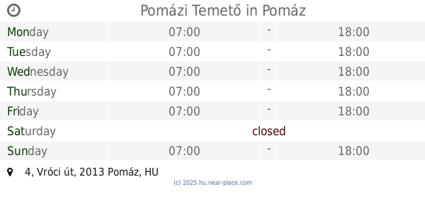
Pomázi Temető
Pomáz, Vróci út 4
Cemetery
read more
4.702 km
Leányfalu temető
Leányfalu, Temető utca
Cemetery
read more
4.708 km
Leányfalui temető
Leányfalu
Cemetery
read more
5.325 km
Pesti úti temető
Göd, Pesti út 156
Cemetery
read more
5.461 km
Temető
Pócsmegyer
Cemetery
read more
5.703 km
Fő úti temető
Dunakeszi
Cemetery
read more
5.721 km
Kegyeleti park (lezárt temető) - Dunakeszi
Dunakeszi, Fő út 62
Cemetery
read more
8.486 km
Tahitótfalui Katolikus Temető
Tahitótfalu, Zrínyi utca
Cemetery
read more
9.391 km
Pilisborosjenői temető
Pilisborosjenő
Cemetery
read more
11.58 km
Avar utcai temető
Vác
Cemetery
read more
13.258 km
Dunabogdányi temető
Dunabogdány, Plébánia út 4
Cemetery
read more
17.162 km
Rádi temető
Rád
Cemetery
read more
📑
all categories
Accounting
Administrative area level 1
Administrative area level 2
Airport
Amusement park
Aquarium
Art gallery
Atm
Bakery
Bank
Bar
Beauty salon
Bicycle store
Book store
Bowling alley
Bus station
Cafe
Campground
Car dealer
Car rental
Car repair
Car wash
Casino
Cemetery
Church
City hall
Clothing store
Colloquial area
Convenience store
Country
Courthouse
Dentist
Department store
Doctor
Electrician
Electronics store
Embassy
Finance
Fire station
Florist
Food
Funeral home
Furniture store
Gas station
General contractor
Grocery or supermarket
Gym
Hair care
Hardware store
Health
Hindu Temple
Home goods store
Hospital
Insurance agency
Intersection
Jewelry store
Laundry
Lawyer
Library
Light rail station
Liquor store
Local government office
Locality
Locksmith
Lodging
Meal delivery
Meal takeaway
Mosque
Movie rental
Movie theater
Moving company
Museum
Natural feature
Neighborhood
Night club
Painter
Park
Parking
Pet store
Pharmacy
Physiotherapist
Place of worship
Plumber
Point of interest
Police
Political
Post office
Premise
Real estate agency
Restaurant
Roofing contractor
Route
Rv park, camping
School
Shoe store
Shopping mall
Spa
Stadium
Storage
Store
Subpremise
Subway station
Supermarket
Synagogue
Taxi stand
Train station
Transit station
Travel agency
University
Veterinary care
Zoo
administrative area level 3
sublocality level 1
↑