Cafe nearby Volt Café
Hungary
Cafe nearby Volt Café
Volt Café
Sopron, Deák tér 43 Magyarország
contacts phone
:
+36
Latitude:
47.6799037
, Longitude:
16.5890298
read more
nearest Cafe
207 m
Állomás Tabak Trafik (DSZT Trafik Bt.)
Sopron, Bartók Béla utca 7
Cafe
read more
254 m
MoneyTours Büfé
Sopron, Bartók Béla utca
Cafe
read more
333 m
Dömötöri Patisserie and Cafe
Sopron, Széchenyi tér 13.
Cafe
read more
333 m
Dömötöri Cukrászda és Kávézó
Sopron, Széchenyi tér 13.
Cafe
read more
355 m
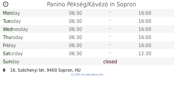
Panino Pékség/Kávézó
Sopron, Széchenyi tér 16
Cafe
read more
355 m
Panino Bakery / Café
Sopron, Széchenyi tér 16
Cafe
read more
373 m
Liszt Cafe
Sopron, Széchenyi tér 15
Cafe
read more
440 m
El Gusto
Sopron, Várkerület 79
Cafe
read more
518 m
Buddha Cafe
Sopron, Béke út 10
Cafe
read more
581 m
Korzó Kávézó
Sopron, Füredi Oszkár sétány 5
Cafe
read more
592 m
Mézes Teaház
Sopron, Várkerület 65
Cafe
read more
614 m
Tramini Borozó-Kávézó
Sopron, Várkerület 63
Cafe
read more
642 m
Kultúrpresszó
Sopron, Várkerület 96
Cafe
read more
676 m
Kultúrpresszó
Sopron, Várkerület 92
Cafe
read more
680 m
Zwinger Kávéház
Sopron, Várkerület 92
Cafe
read more
693 m
Warmcup Café Sopron
Sopron, Kolostor utca 1
Cafe
read more
724 m
Viktória Fagyizó És Kávézó
Sopron, Várkerület 84
Cafe
read more
742 m
Castle Garden Café & Wine
Sopron, Várkerület 49
Cafe
read more
742 m
Várker Café & Wine
Sopron, Várkerület 49
Cafe
read more
774 m
Folkart Kávézó
Sopron, Várkerület 70
Cafe
read more
787 m
Segafredo Kávézó (Jaksa és Társa Kft.)
Sopron, Színház utca 5
Cafe
read more
790 m
Kasléder Teaház & Kávézó
Sopron, Színház utca 7
Cafe
read more
799 m
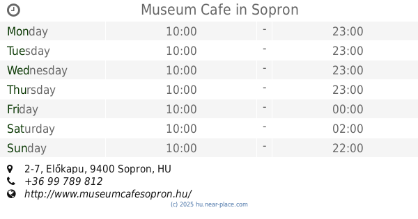
Museum Cafe
Sopron, Előkapu 2-7
Cafe
read more
817 m
Cocos Healthy Food
Sopron, Grabenrunde
Cafe
read more
825 m
Cafe Randevú Kávézó
Sopron, Várkerület 30
Cafe
read more
📑
all categories
Accounting
Administrative area level 1
Administrative area level 2
Airport
Amusement park
Aquarium
Art gallery
Atm
Bakery
Bank
Bar
Beauty salon
Bicycle store
Book store
Bowling alley
Bus station
Cafe
Campground
Car dealer
Car rental
Car repair
Car wash
Casino
Cemetery
Church
City hall
Clothing store
Colloquial area
Convenience store
Country
Courthouse
Dentist
Department store
Doctor
Electrician
Electronics store
Embassy
Finance
Fire station
Florist
Food
Funeral home
Furniture store
Gas station
General contractor
Grocery or supermarket
Gym
Hair care
Hardware store
Health
Hindu Temple
Home goods store
Hospital
Insurance agency
Intersection
Jewelry store
Laundry
Lawyer
Library
Light rail station
Liquor store
Local government office
Locality
Locksmith
Lodging
Meal delivery
Meal takeaway
Mosque
Movie rental
Movie theater
Moving company
Museum
Natural feature
Neighborhood
Night club
Painter
Park
Parking
Pet store
Pharmacy
Physiotherapist
Place of worship
Plumber
Point of interest
Police
Political
Post office
Premise
Real estate agency
Restaurant
Roofing contractor
Route
Rv park, camping
School
Shoe store
Shopping mall
Spa
Stadium
Storage
Store
Subpremise
Subway station
Supermarket
Synagogue
Taxi stand
Train station
Transit station
Travel agency
University
Veterinary care
Zoo
administrative area level 3
sublocality level 1
↑