Cafe nearby Tinnyei Teniszklub
Hungary
Cafe nearby Tinnyei Teniszklub
Tinnyei Teniszklub
40, Petőfi Sándor utca, 2086, Tinnye, HU Węgry
contacts phone
:
+36 26 600 259
website:
tinnyeitenisz.hu
Latitude:
47.623665
, Longitude:
18.7705219
larger map & directions
read more
nearest Cafe
3.784 km
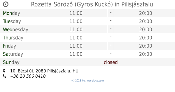
Rozetta Söröző (Gyros Kuckó)
Pilisjászfalu, Bécsi út 10
Cafe
read more
3.813 km
Nemzeti Dohánybolt
Perbál, Fő utca
Cafe
read more
3.813 km
National tobacco shop
Perbál, Fő utca
Cafe
read more
4.285 km
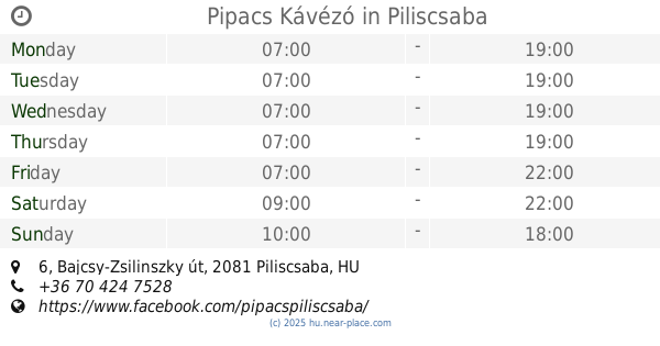
Pipacs Kávézó
Piliscsaba, Bajcsy-Zsilinszky út 6
Cafe
read more
4.301 km
Édes Anna Cukrászda
Piliscsaba, Templom tér 4
Cafe
read more
4.517 km
Kati Néni Kocsmája
Piliscsaba, Fő út 96
Cafe
read more
9.407 km
Dióhéj
Zsámbék, 5, Corvin János utca
Cafe
read more
9.431 km
ReBa kávézó
Pilisvörösvár, -32, Kisfaludy utca 30
Cafe
read more
9.72 km
Lilipop Kávéház
Nagykovácsi, Kossuth Lajos utca 109/a
Cafe
read more
10.147 km
Szántó Presszó
Ercsi, 6 6
Cafe
read more
11.306 km
Balay Club - Playhouse and Cafe
Dorog, Rákóczi Ferenc utca 5
Cafe
read more
13.639 km
DasCafè- a Kávézó és Gasztró Bisztró
Herceghalom, Gesztenyés út 45
Cafe
read more
14.565 km
Zsindelyes
Pilisszentkereszt, Eötvös Lóránd utca 10
Cafe
read more
14.632 km
Cafeteria Vivaldi
Esztergom, 111
Cafe
read more
14.752 km
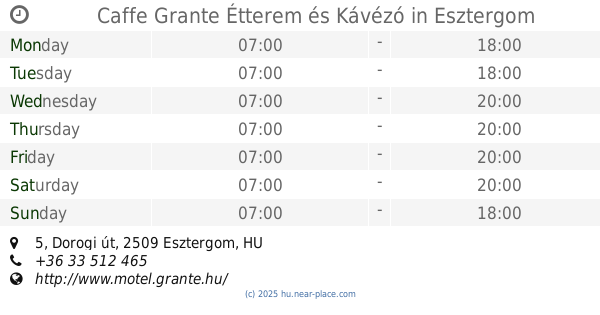
Caffe Grante Étterem és Kávézó
Esztergom, Dorogi út 5
Cafe
read more
15.129 km
Marika presszó
Tát, Ifjúság út 34
Cafe
read more
16.205 km
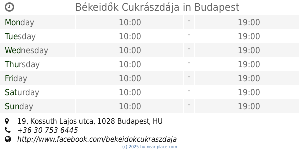
Békeidők Cukrászdája
Budapest, Kossuth Lajos utca 19
Cafe
read more
16.614 km
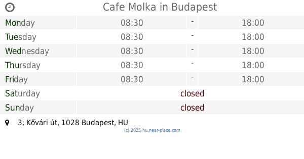
Cafe Molka
Budapest, Kővári út 3
Cafe
read more
16.919 km
Costa Coffee
Budapest, Hidegkúti út 1
Cafe
read more
16.919 km
Costa Coffee - Hűvösvölgy
Budapest, Hidegkúti út 1
Cafe
read more
17.256 km
Prosit Bar & Café
Budakeszi, Fő utca 147
Cafe
read more
17.334 km
Babszem Kávézó és Reggeliző
Budakeszi, 188 Fő utca
Cafe
read more
17.609 km
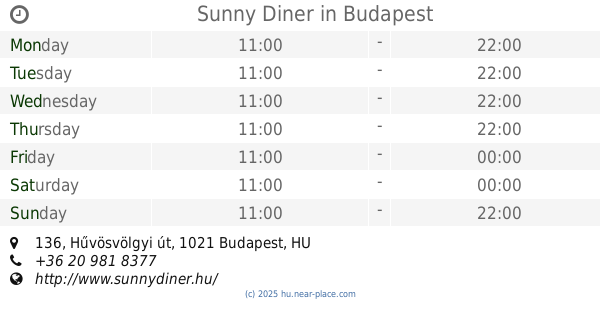
Sunny Diner
Budapest, Hűvösvölgyi út 136
Cafe
read more
18.392 km
Kilátó Kávézó
Budapest
Cafe
read more
20.005 km
Pergola Café
Budapest, Eötvös út 52
Cafe
read more
📑
all categories
Accounting
Administrative area level 1
Administrative area level 2
Airport
Amusement park
Aquarium
Art gallery
Atm
Bakery
Bank
Bar
Beauty salon
Bicycle store
Book store
Bowling alley
Bus station
Cafe
Campground
Car dealer
Car rental
Car repair
Car wash
Casino
Cemetery
Church
City hall
Clothing store
Colloquial area
Convenience store
Country
Courthouse
Dentist
Department store
Doctor
Electrician
Electronics store
Embassy
Finance
Fire station
Florist
Food
Funeral home
Furniture store
Gas station
General contractor
Grocery or supermarket
Gym
Hair care
Hardware store
Health
Hindu Temple
Home goods store
Hospital
Insurance agency
Intersection
Jewelry store
Laundry
Lawyer
Library
Light rail station
Liquor store
Local government office
Locality
Locksmith
Lodging
Meal delivery
Meal takeaway
Mosque
Movie rental
Movie theater
Moving company
Museum
Natural feature
Neighborhood
Night club
Painter
Park
Parking
Pet store
Pharmacy
Physiotherapist
Place of worship
Plumber
Point of interest
Police
Political
Post office
Premise
Real estate agency
Restaurant
Roofing contractor
Route
Rv park, camping
School
Shoe store
Shopping mall
Spa
Stadium
Storage
Store
Subpremise
Subway station
Supermarket
Synagogue
Taxi stand
Train station
Transit station
Travel agency
University
Veterinary care
Zoo
administrative area level 3
sublocality level 1
↑