Cafe nearby Salubrious Project
Hungary
Cafe nearby Salubrious Project
Salubrious Project
Kaposhomok, Rákóczi Ferenc utca 19 Magyarország
contacts phone
:
+36
Latitude:
46.362585
, Longitude:
17.919709
read more
nearest Cafe
9.159 km
Császár Vendéglő (Lottózó)
Kaposvár, Kaposrét sor 77
Cafe
read more
9.159 km
Emperor Restaurant (lottery)
Kaposvár, Kaposrét sor 77
Cafe
read more
9.293 km
Mokka Kávészaküzlet-Kávézó
Kaposvár, Németh István fasor 25
Cafe
read more
9.636 km
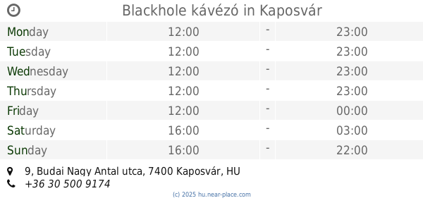
Blackhole kávézó
Kaposvár, Budai Nagy Antal utca 9
Cafe
read more
9.637 km
e-Cafe
Kaposvár, Budai Nagy Antal utca 9
Cafe
read more
9.679 km
Park Café
Kaposvár, Berzsenyi park
Cafe
read more
9.763 km
Sasa Caffee Espresso
Kaposvár, Fő utca 23
Cafe
read more
9.883 km
Egykávézó
Kaposvár, Kossuth Lajos utca 8
Cafe
read more
9.948 km
Cafe Frei Kaposvár
Kaposvár, Teleki utca 7
Cafe
read more
9.989 km
Gard'Ann Cukrászda
Kaposvár, Fő utca 4
Cafe
read more
10.043 km
Royal kávéház
Kaposvár, Fő utca 2
Cafe
read more
10.105 km
Central Kávézó
Kaposvár, Noszlopy Gáspár utca 8
Cafe
read more
10.108 km
Rotonda Café
Kaposvár, Noszlopy Gáspár utca 10
Cafe
read more
10.108 km
Rotonda
Kaposvár, Noszlopy Gáspár utca 10
Cafe
read more
10.108 km
Rotonda
Kaposvár, Áchim András utca
Cafe
read more
10.108 km
Slendy Süti és pékáru mintabolt
Kaposvár, Honvéd utca 10
Cafe
read more
10.131 km
Mandoletti Kávézó
Kaposvár, Zárda utca 10
Cafe
read more
10.143 km
Frei Café
Budapest, Széll Kálmán tér
Cafe
read more
10.149 km
Florida Burger City
Kaposvár, Zárda utca 3
Cafe
read more
10.243 km
Rosco Kávézó
Kaposvár, Áchim András utca
Cafe
read more
10.301 km
New York kávézó
Kaposvár, Petőfi utca 19
Cafe
read more
10.674 km
Caffe Brando
Kaposvár, Cseri út 2
Cafe
read more
11.785 km
Szivárvány Eszpresszó
Kaposvár, Frankel Leó utca 1
Cafe
read more
15.649 km
Kanyar Fagyizó
Bőszénfa, 6621, a, Fő utca 53
Cafe
read more
21.216 km
Netcafe Somogyjád
Somogyjád, Bogáti utca 1
Cafe
read more
📑
all categories
Accounting
Administrative area level 1
Administrative area level 2
Airport
Amusement park
Aquarium
Art gallery
Atm
Bakery
Bank
Bar
Beauty salon
Bicycle store
Book store
Bowling alley
Bus station
Cafe
Campground
Car dealer
Car rental
Car repair
Car wash
Casino
Cemetery
Church
City hall
Clothing store
Colloquial area
Convenience store
Country
Courthouse
Dentist
Department store
Doctor
Electrician
Electronics store
Embassy
Finance
Fire station
Florist
Food
Funeral home
Furniture store
Gas station
General contractor
Grocery or supermarket
Gym
Hair care
Hardware store
Health
Hindu Temple
Home goods store
Hospital
Insurance agency
Intersection
Jewelry store
Laundry
Lawyer
Library
Light rail station
Liquor store
Local government office
Locality
Locksmith
Lodging
Meal delivery
Meal takeaway
Mosque
Movie rental
Movie theater
Moving company
Museum
Natural feature
Neighborhood
Night club
Painter
Park
Parking
Pet store
Pharmacy
Physiotherapist
Place of worship
Plumber
Point of interest
Police
Political
Post office
Premise
Real estate agency
Restaurant
Roofing contractor
Route
Rv park, camping
School
Shoe store
Shopping mall
Spa
Stadium
Storage
Store
Subpremise
Subway station
Supermarket
Synagogue
Taxi stand
Train station
Transit station
Travel agency
University
Veterinary care
Zoo
administrative area level 3
sublocality level 1
↑