Cafe nearby Paparazzi Terrace
Hungary
Cafe nearby Paparazzi Terrace
Paparazzi Terrace
Debrecen, Piac utca Ungarn
contacts phone
:
+36
Latitude:
47.5279098
, Longitude:
21.625656
read more
nearest Cafe
39 m
RoBoss Cafe
Debrecen, u 4025, Piac utca 41
Cafe
read more
198 m
Cafe Frei Debrecen Főtér
Debrecen, Piac utca 20
Cafe
read more
200 m
Inca Café
Debrecen, Simonffy utca 2/B
Cafe
read more
253 m
Cut & Coffee Debrecen
Debrecen, b, Hal köz 3
Cafe
read more
258 m
Menta coffee
Debrecen, 4025, Piac utca 17
Cafe
read more
305 m
Korzó Édesség és Kávézó
Debrecen, 4024, Csapó utca 1
Cafe
read more
333 m
Starbucks
Debrecen, Kossuth utca 1
Cafe
read more
347 m
Starbucks
Debrecen, Piac utca 5-11
Cafe
read more
426 m
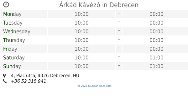
Árkád Kávézó
Debrecen, Piac utca 4
Cafe
read more
497 m
Black Sheep Microroastery & Coffee
Debrecen, Csapó utca 23
Cafe
read more
514 m
Levendula icecream
Debrecen, Csapó utca 25
Cafe
read more
527 m
Leovit Coffee To Go
Debrecen, Vár utca 10/c
Cafe
read more
546 m
Latin Cafè
Debrecen, 4024, Csapó utca 28
Cafe
read more
562 m
Starbucks
Debrecen, Csapó utca 30
Cafe
read more
566 m
Nemzeti Dohánybolt
Debrecen, Kossuth utca 45
Cafe
read more
566 m
National tobacco shop
Debrecen, Kossuth utca 45
Cafe
read more
578 m
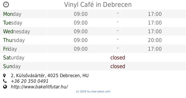
Vinyl Café
Debrecen, Külsővásártér 2
Cafe
read more
594 m
Coffeeshop Company
Debrecen, Csapó utca 30
Cafe
read more
667 m
Cafe Frei Debrecen
Debrecen, Rákóczi utca 18
Cafe
read more
667 m
Cafe Frei Debrecen Fórum
Debrecen, Csapó utca 30
Cafe
read more
745 m
Valentino Ristorante
Debrecen, Csapó utca 51
Cafe
read more
766 m
Susmus Café
Debrecen, Darabos utca 19
Cafe
read more
776 m
Caffe Amici Gourmet Coffee
Debrecen, Péterfia utca 15
Cafe
read more
1.237 km
Néro Caffe
Debrecen, Csillag utca 10
Cafe
read more
1.324 km
Ibolya Cukrászda
Debrecen, Bercsényi Miklós utca 4
Cafe
read more
📑
all categories
Accounting
Administrative area level 1
Administrative area level 2
Airport
Amusement park
Aquarium
Art gallery
Atm
Bakery
Bank
Bar
Beauty salon
Bicycle store
Book store
Bowling alley
Bus station
Cafe
Campground
Car dealer
Car rental
Car repair
Car wash
Casino
Cemetery
Church
City hall
Clothing store
Colloquial area
Convenience store
Country
Courthouse
Dentist
Department store
Doctor
Electrician
Electronics store
Embassy
Finance
Fire station
Florist
Food
Funeral home
Furniture store
Gas station
General contractor
Grocery or supermarket
Gym
Hair care
Hardware store
Health
Hindu Temple
Home goods store
Hospital
Insurance agency
Intersection
Jewelry store
Laundry
Lawyer
Library
Light rail station
Liquor store
Local government office
Locality
Locksmith
Lodging
Meal delivery
Meal takeaway
Mosque
Movie rental
Movie theater
Moving company
Museum
Natural feature
Neighborhood
Night club
Painter
Park
Parking
Pet store
Pharmacy
Physiotherapist
Place of worship
Plumber
Point of interest
Police
Political
Post office
Premise
Real estate agency
Restaurant
Roofing contractor
Route
Rv park, camping
School
Shoe store
Shopping mall
Spa
Stadium
Storage
Store
Subpremise
Subway station
Supermarket
Synagogue
Taxi stand
Train station
Transit station
Travel agency
University
Veterinary care
Zoo
administrative area level 3
sublocality level 1
↑