Cafe nearby Paning Kft.
Hungary
Cafe nearby Paning Kft.
Paning Kft.
Monor, Ady Endre utca 19 Magyarország
contacts phone
:
+36
Latitude:
47.3507902
, Longitude:
19.4410301
read more
nearest Cafe
68 m
The Hatter
Monor, Ady Endre utca 17
Cafe
read more
68 m
A Kalapos
Monor, Ady Endre utca 17
Cafe
read more
354 m
Fagyöngy Fagyizó és Kávézó Terasz
Monor, Kossuth Lajos utca 71
Cafe
read more
534 m
Rigoletto Ice
Monor, Kossuth Lajos utca 93
Cafe
read more
534 m
RIGOLETTÓ Fagylaltozó
Monor, Kossuth Lajos utca 93
Cafe
read more
534 m
RIGOLETTÓ Fagylaltozó
Monor, Kossuth Lajos út 93
Cafe
read more
8.303 km
Italdiszkont
Üllő, Ócsai út 41
Cafe
read more
8.679 km
Fincsi Bufe
Gyömrő, Szent István út 20a
Cafe
read more
8.761 km
Chameeleon Coffee
Gyömrő, Szent István út 23-33
Cafe
read more
11.133 km
Szarvas
Nyáregyháza, Temesvári út 2
Cafe
read more
12.113 km
Vénusz 2 Panzió
Inárcs, M5 autópálya Inárcsi Pihenő, 35km
Cafe
read more
12.357 km
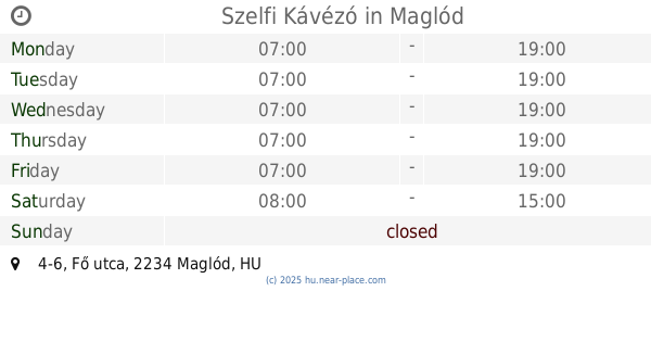
Szelfi Kávézó
Maglód, Fő utca 4-6
Cafe
read more
12.907 km
Alfa Cafe
Maglód, Bajcsy-Zsilinszky utca 71
Cafe
read more
14.034 km
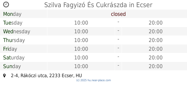
Szilva Fagyizó És Cukrászda
Ecser, 2233, Rákóczi utca 2-4
Cafe
read more
14.927 km
Malom Söröző és Kávézó
Tápióság, Szentmártonkátai út 2
Cafe
read more
15.248 km
Újhartyán Presszó
Újhartyán, Fő utca 31
Cafe
read more
15.485 km
Lesz Vigasz Söröző
Vecsés, Attila utca 22
Cafe
read more
15.741 km
Aviation Cultural Center
Budapest, BUD
Cafe
read more
16.209 km
Coffeeshop Company
Vecsés, Fő út 246-248
Cafe
read more
16.266 km
Camden Food Co.
Budapest, 1185, Liszt Ferenc tér
Cafe
read more
16.373 km
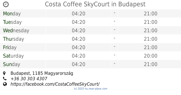
Costa Coffee SkyCourt
Budapest
Cafe
read more
17.275 km
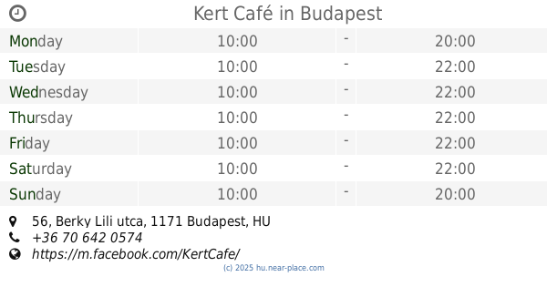
Kert Café
Budapest, Berky Lili utca 56
Cafe
read more
17.468 km
Nemzeti Dohánybolt
Albertirsa, Vasút utca 4
Cafe
read more
19.493 km
Autós Fagyizó
Dabas, Szent János út 47
Cafe
read more
20.03 km
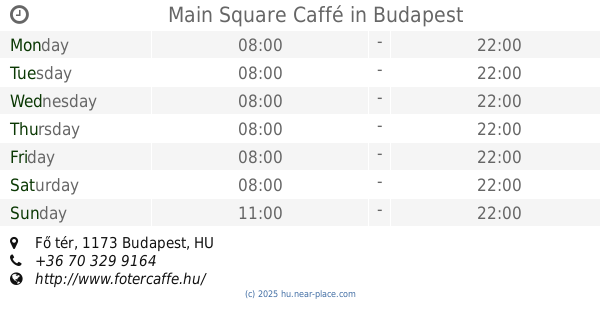
Main Square Caffé
Budapest, Fő tér
Cafe
read more
📑
all categories
Accounting
Administrative area level 1
Administrative area level 2
Airport
Amusement park
Aquarium
Art gallery
Atm
Bakery
Bank
Bar
Beauty salon
Bicycle store
Book store
Bowling alley
Bus station
Cafe
Campground
Car dealer
Car rental
Car repair
Car wash
Casino
Cemetery
Church
City hall
Clothing store
Colloquial area
Convenience store
Country
Courthouse
Dentist
Department store
Doctor
Electrician
Electronics store
Embassy
Finance
Fire station
Florist
Food
Funeral home
Furniture store
Gas station
General contractor
Grocery or supermarket
Gym
Hair care
Hardware store
Health
Hindu Temple
Home goods store
Hospital
Insurance agency
Intersection
Jewelry store
Laundry
Lawyer
Library
Light rail station
Liquor store
Local government office
Locality
Locksmith
Lodging
Meal delivery
Meal takeaway
Mosque
Movie rental
Movie theater
Moving company
Museum
Natural feature
Neighborhood
Night club
Painter
Park
Parking
Pet store
Pharmacy
Physiotherapist
Place of worship
Plumber
Point of interest
Police
Political
Post office
Premise
Real estate agency
Restaurant
Roofing contractor
Route
Rv park, camping
School
Shoe store
Shopping mall
Spa
Stadium
Storage
Store
Subpremise
Subway station
Supermarket
Synagogue
Taxi stand
Train station
Transit station
Travel agency
University
Veterinary care
Zoo
administrative area level 3
sublocality level 1
↑