Cafe nearby No.1 Étterem és Vendégház
Hungary
Cafe nearby No.1 Étterem és Vendégház
No.1 Étterem és Vendégház
Parád, Kristály út Hungary
contacts phone
:
+36
Latitude:
47.9252947
, Longitude:
20.0559472
read more
nearest Cafe
2.063 km
Gramofon Kávéház
Parád, Kossuth Lajos út 69
Cafe
read more
3.907 km
Ritz Garden
Recsk, Kossuth Lajos út 120
Cafe
read more
8.689 km
Fanni kávézó
Gyöngyös
Cafe
read more
12.263 km
Innodox Teambuilding
Gyöngyös, Parádi út 27
Cafe
read more
12.66 km
Dévai Sarok kávéház
Gyöngyös, Dévai Sándor utca 1
Cafe
read more
14.099 km
Fekete Kecske Söröző
Abasár, Vörösmarty Mihály út 1
Cafe
read more
15.216 km
Kastélykert kávézó
Verpelét
Cafe
read more
17.364 km
Pro Great Bonus Kft
Bátonyterenye, Ózdi út 220
Cafe
read more
18.048 km
Nosztalgia Bár
Gyöngyös, Orczy utca 1
Cafe
read more
18.053 km
Nagy Zoli Cukrászdája
Gyöngyös, Orczy utca 1
Cafe
read more
18.383 km
Hanák Udvar
Gyöngyös, Fő tér 3
Cafe
read more
19.227 km
Lottózó
Gyöngyös, Pesti út 9
Cafe
read more
23.378 km
Boldizsár Cukrászda
Eger, Törvényház utca 4
Cafe
read more
23.724 km
Update Lowcarb Shop & Coffee Bar
Eger, Széchenyi István utca 23
Cafe
read more
23.801 km
Pöttyös Kávézó
Eger, Katona István tér 5
Cafe
read more
23.803 km
Kórházi Kávézó
Eger, Knézich Károly utca 9
Cafe
read more
23.893 km
Caffe Rouge
Eger, Hatvani kapu tér 1
Cafe
read more
23.909 km
Lipóti Bakery
Eger, Érsek utca 2
Cafe
read more
24.056 km
Caffe Dolce Vita
Eger, Dobó István tér 3
Cafe
read more
24.094 km
Eger Pasa Tent
Eger, Dobó István utca 34
Cafe
read more
24.177 km
Görög Kávézó and Pallas Caffe
Eger, Dobó István utca 20-22
Cafe
read more
24.242 km
Béé Bistro
Eger, Egészségház utca 5
Cafe
read more
24.882 km
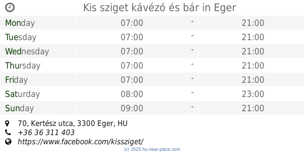
Kis sziget kávézó és bár
Eger, Kertész utca 70
Cafe
read more
25.166 km
Welness Kávé
Eger, Kárpát utca 13
Cafe
read more
27.089 km
Karancs
Salgotarjan, STÉCÉ Kávéház, Főtér 6
Cafe
read more
📑
all categories
Accounting
Administrative area level 1
Administrative area level 2
Airport
Amusement park
Aquarium
Art gallery
Atm
Bakery
Bank
Bar
Beauty salon
Bicycle store
Book store
Bowling alley
Bus station
Cafe
Campground
Car dealer
Car rental
Car repair
Car wash
Casino
Cemetery
Church
City hall
Clothing store
Colloquial area
Convenience store
Country
Courthouse
Dentist
Department store
Doctor
Electrician
Electronics store
Embassy
Finance
Fire station
Florist
Food
Funeral home
Furniture store
Gas station
General contractor
Grocery or supermarket
Gym
Hair care
Hardware store
Health
Hindu Temple
Home goods store
Hospital
Insurance agency
Intersection
Jewelry store
Laundry
Lawyer
Library
Light rail station
Liquor store
Local government office
Locality
Locksmith
Lodging
Meal delivery
Meal takeaway
Mosque
Movie rental
Movie theater
Moving company
Museum
Natural feature
Neighborhood
Night club
Painter
Park
Parking
Pet store
Pharmacy
Physiotherapist
Place of worship
Plumber
Point of interest
Police
Political
Post office
Premise
Real estate agency
Restaurant
Roofing contractor
Route
Rv park, camping
School
Shoe store
Shopping mall
Spa
Stadium
Storage
Store
Subpremise
Subway station
Supermarket
Synagogue
Taxi stand
Train station
Transit station
Travel agency
University
Veterinary care
Zoo
administrative area level 3
sublocality level 1
↑