Cafe nearby Kakas Presszó
Hungary
Cafe nearby Kakas Presszó
Kakas Presszó
2, Móricz Zsigmond körtér, 1114, Budapest, HU Magyarország
contacts phone
:
+36 70 550 6015
website:
www.facebook.com
Latitude:
47.4781143
, Longitude:
19.0478763
larger map & directions
read more
nearest Cafe
126 m
4 Street Coffee
Móricz Zsigmond Körtér Gomba 3. cikkely, Budapest, Hungary
Cafe
read more
141 m
La nube café (closed for holidays and renovations untill September)
Budapest, Bartók Béla út 41
Cafe
read more
189 m
Édes Érzés Kft.
Budapest, Bartók Béla út 37
Cafe
read more
252 m
Café Ponyvaregény
Budapest, Bercsényi utca 5
Cafe
read more
285 m
iTee Café
Budapest, Villányi út 12
Cafe
read more
297 m
Cafe Frei Allee
Budapest, Váli utca 3
Cafe
read more
320 m
Szamos
Budapest, Kőrösy József utca 2
Cafe
read more
346 m
PupiCake
Budapest, Bartók Béla út 25
Cafe
read more
364 m
Fragrant Desszert
Budapest, Bartók Béla út 30
Cafe
read more
372 m
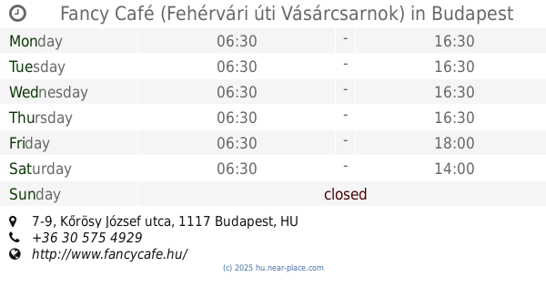
Fancy Café (Fehérvári úti Vásárcsarnok)
Budapest, Kőrösy József utca 7-9
Cafe
read more
372 m
Fancy Café (Fehérvári Street Market)
Budapest, Kőrösy József utca 7-9
Cafe
read more
478 m
ZENta Cafe
Budapest, 5, Zenta utca
Cafe
read more
524 m
Trió Presszó
Budapest, Somlói út 7
Cafe
read more
525 m
Stühmer csokoládé
Budapest, Bartók Béla út 18
Cafe
read more
664 m
TINTA ART CAFÈ
Budapest, Bartók Béla út 1
Cafe
read more
673 m
Bocskai Fagyizó
Budapest
Cafe
read more
739 m
Tranzit Art Café
Budapest, Tranzit Art Café, Kosztolányi Dezső tér
Cafe
read more
1.087 km
Figs Shop and Café
Budapest, Szirtes út 19
Cafe
read more
1.106 km
Kockacukor
Budapest, Sárbogárdi út 23
Cafe
read more
1.156 km
Bang & Olufsen
Budapest, Fővám tér 11-12
Cafe
read more
1.161 km
BeoPlay Budapest
Budapest, Fővám tér 11-12
Cafe
read more
1.171 km
Solties Bálna Terrace
Budapest, Fővám tér 11-12
Cafe
read more
1.196 km
Déli büfé
Budapest, Sóház utca 9
Cafe
read more
1.225 km
Coffeeshop Company
Budapest, 3, Mátyás utca 1
Cafe
read more
1.312 km
Market Cafe-Restaurant & Info-Point
Budapest, Pipa utca 6
Cafe
read more
📑
all categories
Accounting
Administrative area level 1
Administrative area level 2
Airport
Amusement park
Aquarium
Art gallery
Atm
Bakery
Bank
Bar
Beauty salon
Bicycle store
Book store
Bowling alley
Bus station
Cafe
Campground
Car dealer
Car rental
Car repair
Car wash
Casino
Cemetery
Church
City hall
Clothing store
Colloquial area
Convenience store
Country
Courthouse
Dentist
Department store
Doctor
Electrician
Electronics store
Embassy
Finance
Fire station
Florist
Food
Funeral home
Furniture store
Gas station
General contractor
Grocery or supermarket
Gym
Hair care
Hardware store
Health
Hindu Temple
Home goods store
Hospital
Insurance agency
Intersection
Jewelry store
Laundry
Lawyer
Library
Light rail station
Liquor store
Local government office
Locality
Locksmith
Lodging
Meal delivery
Meal takeaway
Mosque
Movie rental
Movie theater
Moving company
Museum
Natural feature
Neighborhood
Night club
Painter
Park
Parking
Pet store
Pharmacy
Physiotherapist
Place of worship
Plumber
Point of interest
Police
Political
Post office
Premise
Real estate agency
Restaurant
Roofing contractor
Route
Rv park, camping
School
Shoe store
Shopping mall
Spa
Stadium
Storage
Store
Subpremise
Subway station
Supermarket
Synagogue
Taxi stand
Train station
Transit station
Travel agency
University
Veterinary care
Zoo
administrative area level 3
sublocality level 1
↑