Cafe nearby Édes Velence Cukrászda
Hungary
Cafe nearby Édes Velence Cukrászda
Édes Velence Cukrászda
68, Fő utca, 2481, Velence, HU Hungary
contacts phone
:
+36 70 234 5673
Latitude:
47.2390025
, Longitude:
18.644596
larger map & directions
read more
nearest Cafe
182 m
Drótszamár Fagyizó
Velence, 2, Kemping utca
Cafe
read more
1.457 km
Toscana Kávézó
Velence, Tópart utca 40
Cafe
read more
1.457 km
Cafe Toscana
Velence, Tópart utca 40
Cafe
read more
3.585 km
Kati Fagyizó
Gárdony, Posta utca 3
Cafe
read more
3.616 km
Klára Büfé Bt.
Gárdony, Szabadság út 1
Cafe
read more
3.75 km
Dolce e Salato
Gárdony, Szabadság út 5
Cafe
read more
3.851 km
Centrum Fagyizó
Gárdony, Szabadság út 16
Cafe
read more
4.734 km
Caffé dock Agard
Agárd, Üdülők útja 11/b
Cafe
read more
4.734 km
Dokk Caffé Agárd
Agárd, Üdülők útja 11/b
Cafe
read more
4.974 km
Bubble Tea Agárd.
Gárdony, Agárd, Zsinór utca
Cafe
read more
5.414 km
CAFÉ69 NAPSUGÁRSTRAND
Gárdony, Chernel István utca
Cafe
read more
5.482 km
Mango Caffe
Gárdony, Ősz utca, HRSZ 3487
Cafe
read more
5.493 km
Park Kávézó
Gárdony, Petőfi utca 1
Cafe
read more
5.734 km
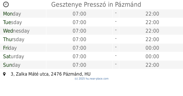
Gesztenye Presszó
Pázmánd, Zalka Máté utca 3
Cafe
read more
6.313 km
Rácz Fagyizó
Gárdony, Bethlen Gábor utca
Cafe
read more
7.671 km
Sport Presszó
Pákozd, Budai út 94
Cafe
read more
8.23 km
Gabo Cukrászda
Pákozd, Budai út 68
Cafe
read more
8.609 km
Limoncello Cukrászda
Pákozd, Budai út 38
Cafe
read more
8.609 km
limoncello Cake Shop
Pákozd, Budai út 38
Cafe
read more
9.261 km
Stop- Coffee
Gárdony, Vörösmarty utca
Cafe
read more
13.775 km
Für Elise cafe
Martonvásár, 2462, Emlékezés tere 3
Cafe
read more
13.775 km
Für Elise kávéház
Martonvásár, 2462, Emlékezés tere 3
Cafe
read more
14.245 km
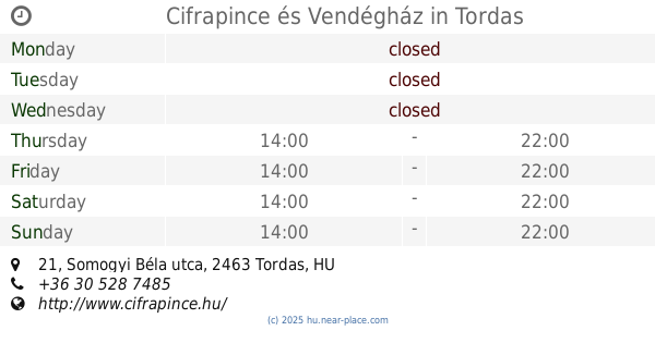
Cifrapince és Vendégház
Tordas, Somogyi Béla utca 21
Cafe
read more
14.245 km
Cifrapince and Guesthouse
Tordas, Somogyi Béla utca 21
Cafe
read more
14.381 km
Pozsonyi kávézó
Székesfehérvár, Dévényi utca 2
Cafe
read more
📑
all categories
Accounting
Administrative area level 1
Administrative area level 2
Airport
Amusement park
Aquarium
Art gallery
Atm
Bakery
Bank
Bar
Beauty salon
Bicycle store
Book store
Bowling alley
Bus station
Cafe
Campground
Car dealer
Car rental
Car repair
Car wash
Casino
Cemetery
Church
City hall
Clothing store
Colloquial area
Convenience store
Country
Courthouse
Dentist
Department store
Doctor
Electrician
Electronics store
Embassy
Finance
Fire station
Florist
Food
Funeral home
Furniture store
Gas station
General contractor
Grocery or supermarket
Gym
Hair care
Hardware store
Health
Hindu Temple
Home goods store
Hospital
Insurance agency
Intersection
Jewelry store
Laundry
Lawyer
Library
Light rail station
Liquor store
Local government office
Locality
Locksmith
Lodging
Meal delivery
Meal takeaway
Mosque
Movie rental
Movie theater
Moving company
Museum
Natural feature
Neighborhood
Night club
Painter
Park
Parking
Pet store
Pharmacy
Physiotherapist
Place of worship
Plumber
Point of interest
Police
Political
Post office
Premise
Real estate agency
Restaurant
Roofing contractor
Route
Rv park, camping
School
Shoe store
Shopping mall
Spa
Stadium
Storage
Store
Subpremise
Subway station
Supermarket
Synagogue
Taxi stand
Train station
Transit station
Travel agency
University
Veterinary care
Zoo
administrative area level 3
sublocality level 1
↑