Cafe nearby Coffeeshop Company
Hungary
Cafe nearby Coffeeshop Company
Coffeeshop Company
2-4, Sport utca, 2040, Budaörs, HU Hungary
contacts phone
:
+36
website:
coffeeshopcompany.hu
Latitude:
47.4564879
, Longitude:
18.9478244
larger map & directions
read more
nearest Cafe
387 m
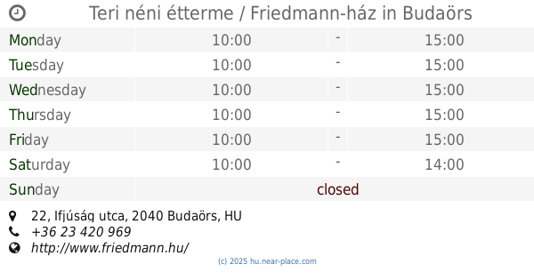
Teri néni étterme / Friedmann-ház
Budaörs, Ifjúság utca 22
Cafe
read more
476 m
Starbucks
Budaörs, Sport utca 2-4
Cafe
read more
524 m
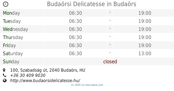
Budaörsi Delicatesse
Budaörs, Szabadság út 100
Cafe
read more
873 m
Le Büfé
Budaörs, Baross utca 146
Cafe
read more
1.266 km
Juhász Café
Budaörs, Templom tér 21
Cafe
read more
1.302 km
Szertár Kávézó
Budaörs, Templom tér 1
Cafe
read more
1.304 km
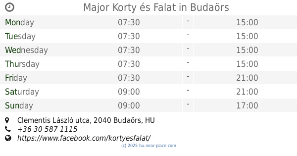
Major Korty és Falat
Budaörs, 22, Clementis László utca
Cafe
read more
1.387 km
Postart Café
Budaörs, Clementis László utca 2
Cafe
read more
1.447 km
Costa Coffee
Budaörs, Kinizsi utca 1-3
Cafe
read more
1.587 km
McCafé
Budaörs, Kinizsi utca 5
Cafe
read more
1.605 km
Montreal Café
Budaörs, BVUSS, Hársfa u 6
Cafe
read more
2.873 km
VE-Kata Kft
Budaörs, Zombori utca 50
Cafe
read more
4.008 km
Campari Café
Budapest, Tippan utca 2
Cafe
read more
4.269 km
Életízek
Budapest, Rétköz utca 45c
Cafe
read more
4.497 km
Open Cafe
Budapest, Retköz utca 7., Eleven Center I. Emelet
Cafe
read more
4.507 km
California Coffee Company
Biatorbágy, Food Court main entrance, Budaörsi út 4
Cafe
read more
4.53 km
Costa Coffee BudaWest
Budapest, Rétköz utca
Cafe
read more
4.722 km
Auguszt cukrászda
Budapest, Sasadi út 190
Cafe
read more
4.722 km
Auguszt Pavilon Cukrászda
Budapest, Sasadi út 190.
Cafe
read more
5.117 km
Sólámpás Központ
Budapest, Kőérberki utca 26
Cafe
read more
5.495 km
Ice cream snacks
Budapest, Háros utca 148
Cafe
read more
5.495 km
Nasi Fagyizó
Budapest, Háros utca 148
Cafe
read more
6.435 km
Dini Confectionery
Budapest, Margaréta utca 6
Cafe
read more
6.685 km
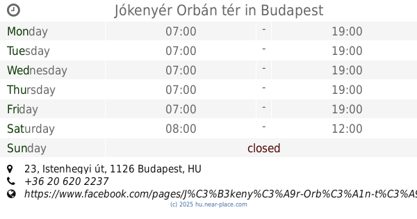
Jókenyér Orbán tér
Budapest, Istenhegyi út 23
Cafe
read more
6.846 km
Cafe Frei
Érd, Iparos utca 5
Cafe
read more
📑
all categories
Accounting
Administrative area level 1
Administrative area level 2
Airport
Amusement park
Aquarium
Art gallery
Atm
Bakery
Bank
Bar
Beauty salon
Bicycle store
Book store
Bowling alley
Bus station
Cafe
Campground
Car dealer
Car rental
Car repair
Car wash
Casino
Cemetery
Church
City hall
Clothing store
Colloquial area
Convenience store
Country
Courthouse
Dentist
Department store
Doctor
Electrician
Electronics store
Embassy
Finance
Fire station
Florist
Food
Funeral home
Furniture store
Gas station
General contractor
Grocery or supermarket
Gym
Hair care
Hardware store
Health
Hindu Temple
Home goods store
Hospital
Insurance agency
Intersection
Jewelry store
Laundry
Lawyer
Library
Light rail station
Liquor store
Local government office
Locality
Locksmith
Lodging
Meal delivery
Meal takeaway
Mosque
Movie rental
Movie theater
Moving company
Museum
Natural feature
Neighborhood
Night club
Painter
Park
Parking
Pet store
Pharmacy
Physiotherapist
Place of worship
Plumber
Point of interest
Police
Political
Post office
Premise
Real estate agency
Restaurant
Roofing contractor
Route
Rv park, camping
School
Shoe store
Shopping mall
Spa
Stadium
Storage
Store
Subpremise
Subway station
Supermarket
Synagogue
Taxi stand
Train station
Transit station
Travel agency
University
Veterinary care
Zoo
administrative area level 3
sublocality level 1
↑