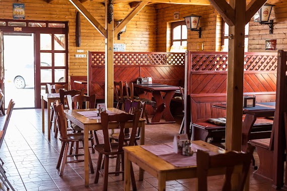
Bar nearby Zúzmara presszó
Hungary
Bar nearby Zúzmara presszó
Zúzmara presszó
Szigetszentmiklós, 2310 Ungarn
contacts phone
:
+36
Latitude:
47.3389561
, Longitude:
19.0351122
larger map & directions
read more
nearest Bar
114 m
Kántor Borozó
Szigetszentmiklós
Bar
read more
307 m
Czifra Söröző és Kávézó
Szigetszentmiklós, Gyári út 52
Bar
read more
456 m
Tett Söröző
Szigetszentmiklós, Iskola utca 2
Bar
read more
533 m
Diófa Söröző
Szigetszentmiklós, Diófa utca 11
Bar
read more
1.253 km
Old School Pub
Szigetszentmiklós, Árpád utca 17
Bar
read more
1.783 km
Bucka Pub Steak House
Szigetszentmiklós, Ádám Jenő sétány 107
Bar
read more
2.261 km
Szupi Drinkbár
Taksony, Fő út 73
Bar
read more
2.514 km
Gyuri-7 BBQ ételek
Szigethalom, Mű út 230
Bar
read more
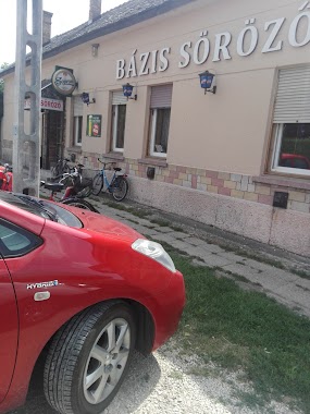
3.596 km
Bázis Söröző
Dunaharaszti, Nádor utca 4
Bar
read more
3.795 km
Géza Bácsi Borozója
Szigethalom, Dunasor 76
Bar
read more
3.838 km
Kanyar/snapszer Söröző
Dunaharaszti, Temető utca 2
Bar
read more
4.384 km
Megálló Söröző
Halásztelek, Ady Endre utca 1
Bar
read more
4.457 km
Gyuri Borozó
Dunaharaszti, Erzsébet utca 2
Bar
read more
4.542 km
Piac Kocsma
Dunaharaszti, Kinizsi Pál utca 18
Bar
read more
4.688 km
Csilla-G Grill büfé
Halásztelek, Korbuly utca 1
Bar
read more
4.781 km
Fradi Kocsma
Dunaharaszti, Móra Ferenc utca 2
Bar
read more
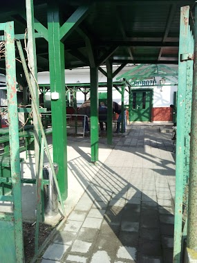
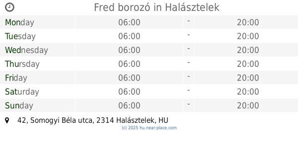
4.812 km
Fred borozó
Halásztelek, Somogyi Béla utca 42
Bar
read more
4.858 km
Eszpresszó
Dunaharaszti, 2330, Festetics Andor utca 10
Bar
read more
7.71 km
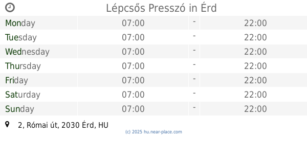
Lépcsős Presszó
Érd, Római út 2
Bar
read more
9.438 km
Olimpia Kocsma
Százhalombatta, Damjanich utca 34
Bar
read more
9.658 km
Bohém Pub
Érd, Diósdi út 17
Bar
read more
10.627 km
Miska Kocsma
Alsónémedi, Magyari utca 14
Bar
read more
13.791 km
Tartine
Budapest, Kopaszi-gát 10
Bar
read more
16.012 km
No Relax bár
Budapest, Balassa Bálint utca 6
Bar
read more
17.291 km
Tó bisztró
Budapest, Bányató utca 12
Bar
read more
📑
all categories
Accounting
Administrative area level 1
Administrative area level 2
Airport
Amusement park
Aquarium
Art gallery
Atm
Bakery
Bank
Bar
Beauty salon
Bicycle store
Book store
Bowling alley
Bus station
Cafe
Campground
Car dealer
Car rental
Car repair
Car wash
Casino
Cemetery
Church
City hall
Clothing store
Colloquial area
Convenience store
Country
Courthouse
Dentist
Department store
Doctor
Electrician
Electronics store
Embassy
Finance
Fire station
Florist
Food
Funeral home
Furniture store
Gas station
General contractor
Grocery or supermarket
Gym
Hair care
Hardware store
Health
Hindu Temple
Home goods store
Hospital
Insurance agency
Intersection
Jewelry store
Laundry
Lawyer
Library
Light rail station
Liquor store
Local government office
Locality
Locksmith
Lodging
Meal delivery
Meal takeaway
Mosque
Movie rental
Movie theater
Moving company
Museum
Natural feature
Neighborhood
Night club
Painter
Park
Parking
Pet store
Pharmacy
Physiotherapist
Place of worship
Plumber
Point of interest
Police
Political
Post office
Premise
Real estate agency
Restaurant
Roofing contractor
Route
Rv park, camping
School
Shoe store
Shopping mall
Spa
Stadium
Storage
Store
Subpremise
Subway station
Supermarket
Synagogue
Taxi stand
Train station
Transit station
Travel agency
University
Veterinary care
Zoo
administrative area level 3
sublocality level 1
↑