Bar nearby Pesti Sörcsarnok
Hungary
Bar nearby Pesti Sörcsarnok
Pesti Sörcsarnok
Budapest, Vámház körút 16 Magyarország
contacts phone
:
+36
Latitude:
47.4884941
, Longitude:
19.0599448
read more
nearest Bar
180 m
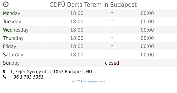
CDFŰ Darts Terem
Budapest, 1056, Fejér György utca 1
Bar
read more
183 m
Ibis
Budapest, Ráday utca 6
Bar
read more
208 m
Rombusz Terasz
Budapest, Ráday utca 10-12
Bar
read more
300 m
Action Bar
Budapest, Magyar utca 42
Bar
read more
336 m
Bécsi Söröző
Budapest, Papnövelde utca 8
Bar
read more
417 m
University Cafe
Budapest, Czuczor utca 5
Bar
read more
488 m
Lezser
Budapest, Lónyay utca 23
Bar
read more
532 m
Favorit Vendéglő
Budapest, Reáltanoda utca 16
Bar
read more
571 m
Julius Meinl Wine Bar
Budapest, Ferenciek tere 7
Bar
read more
621 m
Deus Sofőrszolgálat-a kéklámpás sofőrök
Budapest, Bródy Sándor utca 11-19
Bar
read more
739 m
Központi Italkimérő
Budapest, 1088, Rákóczi út 11
Bar
read more
774 m
Andersen Pub
Budapest, Krúdy Gyula utca 17
Bar
read more
838 m
Virus Cafe
Budapest, Ferenc körút 32
Bar
read more
845 m
Keret Café & Bar
Budapest, Síp utca 5
Bar
read more
927 m
No Name
Budapest, Tompa utca 8
Bar
read more
971 m
Mandarin Cafe
Budapest, Tompa utca 12
Bar
read more
977 m
Chupito Bar - Shots & More
Budapest, 1077, Wesselényi utca 11
Bar
read more
982 m
Szimpla Kert
Budapest, Kazinczy utca 14
Bar
read more
982 m
Aqva Lounge Bar
Budapest, Apáczai Csere János utca 4
Bar
read more
994 m
Kisrabló Pub
Budapest, Zenta utca 3
Bar
read more
1.004 km
Hops Beer Bar
Budapest, 1077, Wesselényi utca 13
Bar
read more
1.016 km
Kola Bistro & Bar
Budapest, Tompa utca 11
Bar
read more
1.021 km
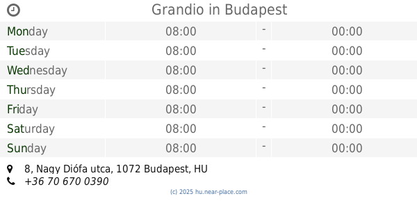
Grandio
Budapest, 1072, Nagy Diófa utca 8
Bar
read more
1.198 km
Casino Disco
Budapest, Dorottya utca 2-4
Bar
read more
1.199 km
Free Pub Crawl
Budapest, Akácfa utca 3
Bar
read more
📑
all categories
Accounting
Administrative area level 1
Administrative area level 2
Airport
Amusement park
Aquarium
Art gallery
Atm
Bakery
Bank
Bar
Beauty salon
Bicycle store
Book store
Bowling alley
Bus station
Cafe
Campground
Car dealer
Car rental
Car repair
Car wash
Casino
Cemetery
Church
City hall
Clothing store
Colloquial area
Convenience store
Country
Courthouse
Dentist
Department store
Doctor
Electrician
Electronics store
Embassy
Finance
Fire station
Florist
Food
Funeral home
Furniture store
Gas station
General contractor
Grocery or supermarket
Gym
Hair care
Hardware store
Health
Hindu Temple
Home goods store
Hospital
Insurance agency
Intersection
Jewelry store
Laundry
Lawyer
Library
Light rail station
Liquor store
Local government office
Locality
Locksmith
Lodging
Meal delivery
Meal takeaway
Mosque
Movie rental
Movie theater
Moving company
Museum
Natural feature
Neighborhood
Night club
Painter
Park
Parking
Pet store
Pharmacy
Physiotherapist
Place of worship
Plumber
Point of interest
Police
Political
Post office
Premise
Real estate agency
Restaurant
Roofing contractor
Route
Rv park, camping
School
Shoe store
Shopping mall
Spa
Stadium
Storage
Store
Subpremise
Subway station
Supermarket
Synagogue
Taxi stand
Train station
Transit station
Travel agency
University
Veterinary care
Zoo
administrative area level 3
sublocality level 1
↑