Bar nearby Nemdebár
Hungary
Bar nearby Nemdebár
Nemdebár
Budapest, 5, Széll Kálmán tér Hungary
contacts phone
:
+36
Latitude:
47.507919
, Longitude:
19.023079
read more
nearest Bar
130 m
Trombitás Söröző
Budapest, Margit körút 101
Bar
read more
248 m
Galeria 12
Budapest, Hajnóczy József utca 21
Bar
read more
252 m
Kétlyukú Söröző
Budapest, Széna tér 5
Bar
read more
261 m
Sanur Presszó
Budapest, Lövőház utca 23
Bar
read more
287 m
Hendrinx
Budapest, Lövőház utca 31
Bar
read more
300 m
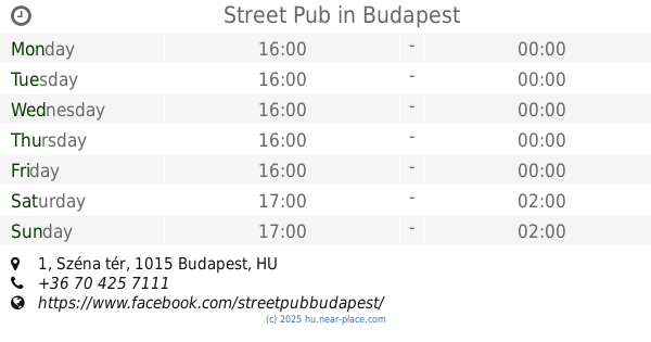
Street Pub
Budapest, Széna tér 1
Bar
read more
332 m
Oscar American Bar
Budapest, Ostrom utca 14
Bar
read more
399 m
Móri Pub
Budapest, Hattyú utca 16
Bar
read more
408 m
Jégkert
Budapest, Margit körút 66
Bar
read more
418 m
Katlan Sörbár
Budapest, Batthyány utca 48
Bar
read more
422 m
Hattyú Caffe
Budapest, Hattyú utca 14
Bar
read more
434 m
Jégkert
Budapest, Bakfark Bálint utca 2
Bar
read more
484 m
Bereg Embassy Bar & Cafe
Budapest, u, Batthyány utca 49
Bar
read more
532 m
4es6os Mammut
Budapest, Margit körút 73
Bar
read more
545 m
NEUGA
Budapest, Jurányi utca 1
Bar
read more
547 m
4-es 6-os Mammut
Budapest, Margit körút 71
Bar
read more
587 m
Fondue bár
Budapest, Keleti Károly utca 25
Bar
read more
594 m
Baltazár Budapest Grill & Boutique Hotel
Budapest, Országház utca 31
Bar
read more
654 m
Café Maison
Budapest, Országház utca 25
Bar
read more
867 m
Club D One
Budapest, Krisztina körút 37
Bar
read more
908 m
Summer Street Bar
Budapest, Hess András tér 3
Bar
read more
913 m
Bahnhof Bisztro
Budapest, Krisztina körút 38
Bar
read more
1.165 km
Rózsa Bisztró
Budapest, Margit körút 7
Bar
read more
1.236 km
Bem Cinema
Budapest, Margit körút 5
Bar
read more
1.236 km
Bem Mozi
Budapest, Margit körút 5
Bar
read more
📑
all categories
Accounting
Administrative area level 1
Administrative area level 2
Airport
Amusement park
Aquarium
Art gallery
Atm
Bakery
Bank
Bar
Beauty salon
Bicycle store
Book store
Bowling alley
Bus station
Cafe
Campground
Car dealer
Car rental
Car repair
Car wash
Casino
Cemetery
Church
City hall
Clothing store
Colloquial area
Convenience store
Country
Courthouse
Dentist
Department store
Doctor
Electrician
Electronics store
Embassy
Finance
Fire station
Florist
Food
Funeral home
Furniture store
Gas station
General contractor
Grocery or supermarket
Gym
Hair care
Hardware store
Health
Hindu Temple
Home goods store
Hospital
Insurance agency
Intersection
Jewelry store
Laundry
Lawyer
Library
Light rail station
Liquor store
Local government office
Locality
Locksmith
Lodging
Meal delivery
Meal takeaway
Mosque
Movie rental
Movie theater
Moving company
Museum
Natural feature
Neighborhood
Night club
Painter
Park
Parking
Pet store
Pharmacy
Physiotherapist
Place of worship
Plumber
Point of interest
Police
Political
Post office
Premise
Real estate agency
Restaurant
Roofing contractor
Route
Rv park, camping
School
Shoe store
Shopping mall
Spa
Stadium
Storage
Store
Subpremise
Subway station
Supermarket
Synagogue
Taxi stand
Train station
Transit station
Travel agency
University
Veterinary care
Zoo
administrative area level 3
sublocality level 1
↑