Bar nearby JÄGER Söröző
Hungary
Bar nearby JÄGER Söröző
JÄGER Söröző
Szentes, Bercsényi utca 31 Węgry
contacts phone
:
+36
Latitude:
46.6601511
, Longitude:
20.2684236
read more
nearest Bar
1.009 km
Drink Café
Szentes, 6600, Kossuth Lajos utca 23
Bar
read more
1.098 km
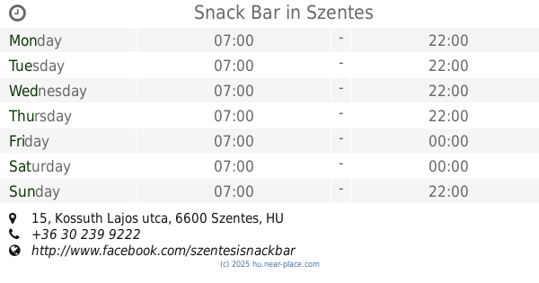
Snack Bar
Szentes, Kossuth Lajos utca 15
Bar
read more
1.823 km
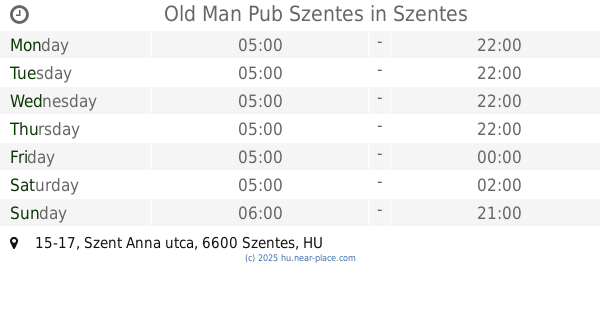
Old Man Pub Szentes
Szentes, 6600, Szent Anna utca 15-17
Bar
read more
9.032 km
Club Diesel
Szegvár, Kossuth tér
Bar
read more
10.199 km
RockPart Tattoo&Bar
Csongrád, Kis-Tisza utca 3
Bar
read more
11.389 km
Galéria söröző
Csongrád, Fő utca 54
Bar
read more
16.528 km
Mámor Presszó
Mindszent
Bar
read more
18.847 km
Fecskefészek Söroző
Tömörkény
Bar
read more
20.369 km
Irish Pub
Kunszentmárton, Bémer László út 1/4
Bar
read more
21.054 km
Horgász Presszó
Mártély, Kossuth utca 1
Bar
read more
21.766 km
Élmény Sport Pub
Mártély, Községház utca 1
Bar
read more
23.252 km
Bowling Söröző
Cserkeszőlő, Fürdő utca 27
Bar
read more
28.059 km
Piros presszó
Hódmezővásárhely, Hódtó utca 2
Bar
read more
30.664 km
Döme Büfé
Lakitelek, Szivárvány utca 34
Bar
read more
30.871 km
Park Falatozó Kocsma
Nagyszénás, Hősök útja 5
Bar
read more
31.012 km
Drink 46 Kávézó
Lakitelek, 6065
Bar
read more
31.128 km
Bacchus Borozó
Lakitelek, Széchenyi körút 64
Bar
read more
31.379 km
Olympia bár
Lakitelek, Széchenyi körút 59
Bar
read more
32.9 km
Nádas büfé
Kiskunfélegyháza, Eötvös utca 9
Bar
read more
37.751 km
Gyöngy Söröző
Békéssámson, Kossuth utca 3
Bar
read more
42.592 km
Hunyadi Söröző
Csorvás, Batthyány utca 6
Bar
read more
42.932 km
Topogó Italbolt
Csorvás, Rákóczi utca 16
Bar
read more
49.662 km
Mámor Söröző
Tószeg, Rákóczi út 2
Bar
read more
51.675 km
Vincent Bar & Pastry
Kecskemét, 6, Szabadság tér
Bar
read more
52.167 km
Holstein Söröző
Makó, Szegedi utca 16
Bar
read more
📑
all categories
Accounting
Administrative area level 1
Administrative area level 2
Airport
Amusement park
Aquarium
Art gallery
Atm
Bakery
Bank
Bar
Beauty salon
Bicycle store
Book store
Bowling alley
Bus station
Cafe
Campground
Car dealer
Car rental
Car repair
Car wash
Casino
Cemetery
Church
City hall
Clothing store
Colloquial area
Convenience store
Country
Courthouse
Dentist
Department store
Doctor
Electrician
Electronics store
Embassy
Finance
Fire station
Florist
Food
Funeral home
Furniture store
Gas station
General contractor
Grocery or supermarket
Gym
Hair care
Hardware store
Health
Hindu Temple
Home goods store
Hospital
Insurance agency
Intersection
Jewelry store
Laundry
Lawyer
Library
Light rail station
Liquor store
Local government office
Locality
Locksmith
Lodging
Meal delivery
Meal takeaway
Mosque
Movie rental
Movie theater
Moving company
Museum
Natural feature
Neighborhood
Night club
Painter
Park
Parking
Pet store
Pharmacy
Physiotherapist
Place of worship
Plumber
Point of interest
Police
Political
Post office
Premise
Real estate agency
Restaurant
Roofing contractor
Route
Rv park, camping
School
Shoe store
Shopping mall
Spa
Stadium
Storage
Store
Subpremise
Subway station
Supermarket
Synagogue
Taxi stand
Train station
Transit station
Travel agency
University
Veterinary care
Zoo
administrative area level 3
sublocality level 1
↑