Bar nearby Haraszthy Pincészet
Hungary
Bar nearby Haraszthy Pincészet
Haraszthy Pincészet
Hungary Węgry
contacts phone
:
+36
Latitude:
47.4380107
, Longitude:
18.7399704
read more
nearest Bar
Haraszthy Pincészet
Etyek, Öreghegy 3108. hrsz.
Bar
read more
284 m
EtyekM. Winery Restaurant
Etyek, Öreghegy, Báthori-dűlő
Bar
read more
284 m
EtyekM. Pince és Présház
Etyek, Öreghegy, Báthori-dűlő
Bar
read more
334 m
Sobol Pincészet
Etyek, Öreghegy présházak
Bar
read more
377 m
Carla Pezsgőház - Kertész Családi Pincészet
Etyek
Bar
read more
817 m
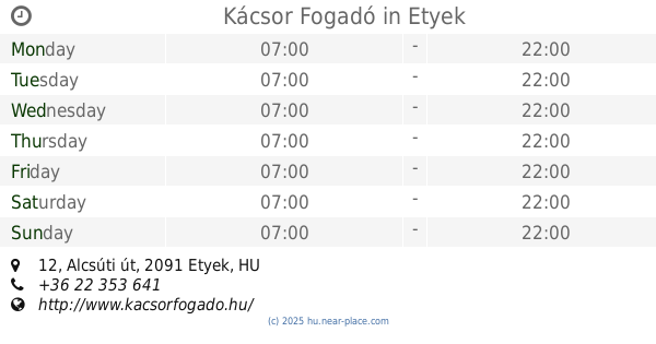
Kácsor Fogadó
Etyek, Alcsúti út 12
Bar
read more
1.106 km
Mérei Pincészet
Etyek, Hegyköz 2
Bar
read more
2.136 km
Gombai Birtok
Etyek, Mester utca 72
Bar
read more
2.202 km
Tátrai Pince
Etyek, Biai út
Bar
read more
7.473 km
Café Chaplin
Biatorbágy, Baross Gábor utca 1
Bar
read more
9.023 km
Bakterház söröző
Bicske, Táncsics Mihály utca 1
Bar
read more
10.873 km
Sági Kocsma
Páty, 2071, Árpád utca 29
Bar
read more
11.334 km
Cseresznyés Kocsma
Páty, 2071, Cseresznyés utca 19
Bar
read more
12.953 km
Gabi Presszó
Zsámbék, Petőfi Sándor utca 86
Bar
read more
13.243 km
Patakparti Költőhely
Csabdi, Béke utca 2
Bar
read more
13.264 km
Borozó
Csabdi, Szabadság utca 39
Bar
read more
14.317 km
Kastély Ingatlanközvetítő Iroda
Érd, Csaba utca 77
Bar
read more
14.396 km
Söröző Óbarok
Óbarok, Fő utca 37
Bar
read more
15.147 km
Bohém Pub
Érd, Diósdi út 17
Bar
read more
16.757 km
Szürke Bika Söröző
Budakeszi, erdő utca 72
Bar
read more
16.871 km
Keceli Borozó
Budakeszi, Kossuth Lajos utca
Bar
read more
17.17 km
Briquette
Budakeszi, Rákóczi utca 73
Bar
read more
17.258 km
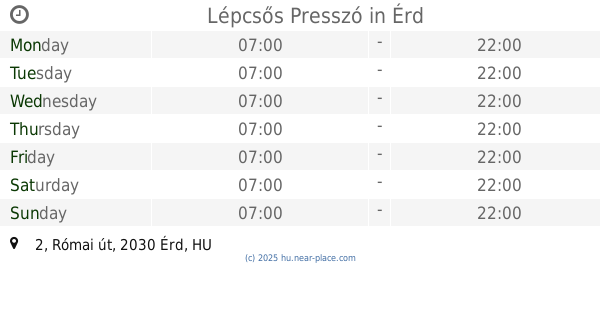
Lépcsős Presszó
Érd, Római út 2
Bar
read more
18.978 km
Olimpia Kocsma
Százhalombatta, Damjanich utca 34
Bar
read more
19.972 km
Nyírfa Italozó
Lovasberény, Hunyadi utca 39
Bar
read more
📑
all categories
Accounting
Administrative area level 1
Administrative area level 2
Airport
Amusement park
Aquarium
Art gallery
Atm
Bakery
Bank
Bar
Beauty salon
Bicycle store
Book store
Bowling alley
Bus station
Cafe
Campground
Car dealer
Car rental
Car repair
Car wash
Casino
Cemetery
Church
City hall
Clothing store
Colloquial area
Convenience store
Country
Courthouse
Dentist
Department store
Doctor
Electrician
Electronics store
Embassy
Finance
Fire station
Florist
Food
Funeral home
Furniture store
Gas station
General contractor
Grocery or supermarket
Gym
Hair care
Hardware store
Health
Hindu Temple
Home goods store
Hospital
Insurance agency
Intersection
Jewelry store
Laundry
Lawyer
Library
Light rail station
Liquor store
Local government office
Locality
Locksmith
Lodging
Meal delivery
Meal takeaway
Mosque
Movie rental
Movie theater
Moving company
Museum
Natural feature
Neighborhood
Night club
Painter
Park
Parking
Pet store
Pharmacy
Physiotherapist
Place of worship
Plumber
Point of interest
Police
Political
Post office
Premise
Real estate agency
Restaurant
Roofing contractor
Route
Rv park, camping
School
Shoe store
Shopping mall
Spa
Stadium
Storage
Store
Subpremise
Subway station
Supermarket
Synagogue
Taxi stand
Train station
Transit station
Travel agency
University
Veterinary care
Zoo
administrative area level 3
sublocality level 1
↑