Bar nearby Hangulat kocsma
Hungary
Bar nearby Hangulat kocsma
Hangulat kocsma
Bácsborsód, Hunyadi János utca 1 Hungary
contacts phone
:
+36
Latitude:
46.093467
, Longitude:
19.1577781
read more
nearest Bar
3.541 km
Jobb, mint otthon pub & coffe bar
Bácsbokod, Kossuth L. utca
Bar
read more
3.675 km
Mediterrán Drink Dealer Kft.
Bácsbokod, Hunyadi János utca 1
Bar
read more
18.252 km
Stop kocsma
Baja, Muskátli utca 2
Bar
read more
18.279 km
Prosit Pub
Baja, Béla király utca 9
Bar
read more
18.279 km
Prosit Kocsma
Baja, Béla király utca 9
Bar
read more
18.354 km
Akvárium
Baja, Szegedi út 8
Bar
read more
18.415 km
Renko söröző
Baja, Attila utca 5
Bar
read more
18.426 km
Cash Bár
Baja, Szentháromság tér 4
Bar
read more
18.676 km
Armstrong Jazz és Rock Club
Baja, u 6500, Türr István utca 2
Bar
read more
18.781 km
Bacchus Borozó
Baja, Árpád utca 15
Bar
read more
18.858 km
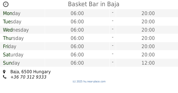
Basket Bar
Baja
Bar
read more
19.437 km
Kaktusz Söröző
Baja, Mártonszállási út
Bar
read more
19.802 km
Sirály Söröző
Baja, Budai Nagy Antal utca 49
Bar
read more
20.355 km
Söröző
Nagybaracska, Dózsa György utca 8
Bar
read more
21.949 km
Zöld Presszó
Szeremle, Kinizsi Pál utca 1
Bar
read more
23.663 km
Teaház
Hercegszántó, Dózsa György utca 8/a
Bar
read more
23.683 km
Presszó
Hercegszántó, Dózsa György utca 11
Bar
read more
23.785 km
Gondűző Bt.
Hercegszántó, Dózsa Gy. u., 57, Dózsa György utca
Bar
read more
32.61 km
Oszvald Pince
Hajós-Pincefalu, Présház utca Hrsz. 7813
Bar
read more
35.811 km
Pittenauer Winery
Császártöltés, Pincesor
Bar
read more
37.566 km
Bu Ta Csi Ga Winery
Császártöltés, Arany János utca 77
Bar
read more
44.533 km
Oázis Büfé
Szekszárd
Bar
read more
46.538 km
Tolna @Drink Bár
Tolna, 7130, Deák Ferenc utca 84
Bar
read more
51.191 km
Old Motors Pub
Kalocsa, 48-as Házak X. utca 8
Bar
read more
59.243 km
Alibi Söröző
Tengelic, Gindli utca
Bar
read more
📑
all categories
Accounting
Administrative area level 1
Administrative area level 2
Airport
Amusement park
Aquarium
Art gallery
Atm
Bakery
Bank
Bar
Beauty salon
Bicycle store
Book store
Bowling alley
Bus station
Cafe
Campground
Car dealer
Car rental
Car repair
Car wash
Casino
Cemetery
Church
City hall
Clothing store
Colloquial area
Convenience store
Country
Courthouse
Dentist
Department store
Doctor
Electrician
Electronics store
Embassy
Finance
Fire station
Florist
Food
Funeral home
Furniture store
Gas station
General contractor
Grocery or supermarket
Gym
Hair care
Hardware store
Health
Hindu Temple
Home goods store
Hospital
Insurance agency
Intersection
Jewelry store
Laundry
Lawyer
Library
Light rail station
Liquor store
Local government office
Locality
Locksmith
Lodging
Meal delivery
Meal takeaway
Mosque
Movie rental
Movie theater
Moving company
Museum
Natural feature
Neighborhood
Night club
Painter
Park
Parking
Pet store
Pharmacy
Physiotherapist
Place of worship
Plumber
Point of interest
Police
Political
Post office
Premise
Real estate agency
Restaurant
Roofing contractor
Route
Rv park, camping
School
Shoe store
Shopping mall
Spa
Stadium
Storage
Store
Subpremise
Subway station
Supermarket
Synagogue
Taxi stand
Train station
Transit station
Travel agency
University
Veterinary care
Zoo
administrative area level 3
sublocality level 1
↑